18180 Résultats
Classification:
documents textuels, photographies
documents textuels, photographies
Numéro de référence:
ARCH168982
Description:
1 feuillet:"Montréal du de Rome" manuscrit par Jacques Rousseau 28 x 21,5 cm 1 feuillet: Description de dessins pour demande de bourse 28 x 21,5 cm 3 feuillets: texte de Jacques Rousseau "La ville et l'architecte" 28 x 21,5 cm 4 feuillets: "Le projet du nouveau port, 1985-1989"
Personnes et institutions:
Titre:
Exposition "Montréal vue de Rome"
Actions:
ARCH168982
Description:
1 feuillet:"Montréal du de Rome" manuscrit par Jacques Rousseau 28 x 21,5 cm 1 feuillet: Description de dessins pour demande de bourse 28 x 21,5 cm 3 feuillets: texte de Jacques Rousseau "La ville et l'architecte" 28 x 21,5 cm 4 feuillets: "Le projet du nouveau port, 1985-1989"
Classification:
documents textuels, photographies
documents textuels, photographies
Personnes et institutions:
Classification:
cartes
cartes
Numéro de référence:
ARCH268032
ARCH268032
Personnes et institutions:
Date:
between 1957 and 1962
between 1957 and 1962
Classification:
cartes
cartes
Date:
between 1957 and 1962
between 1957 and 1962
Personnes et institutions:
Classification:
dessins
dessins
Numéro de référence:
AP046.S1.1983.PR02.179
Description:
This file includes reprographic copies of the Historical Evolution presentation for the Old Port of Montreal and elevation plan of Rue de la Commune showing cross streets.
AP046.S1.1983.PR02.179
Description:
This file includes reprographic copies of the Historical Evolution presentation for the Old Port of Montreal and elevation plan of Rue de la Commune showing cross streets.
Personnes et institutions:
Date:
1990
1990
Titre:
Historical evolution presentation, Old Port of Montreal Master Plan, Montréal, Québec
Actions:
AP046.S1.1983.PR02.179
Description:
This file includes reprographic copies of the Historical Evolution presentation for the Old Port of Montreal and elevation plan of Rue de la Commune showing cross streets.
Classification:
dessins
dessins
Date:
1990
1990
Personnes et institutions:
Classification:
dessins
dessins
Numéro de référence:
AP046.S1.1983.PR02.203
Description:
This file includes maps of the old port area, City of Montreal land use maps, ground figure for the Old Port, and overall plan for the Faubourg Quebec project.
AP046.S1.1983.PR02.203
Description:
This file includes maps of the old port area, City of Montreal land use maps, ground figure for the Old Port, and overall plan for the Faubourg Quebec project.
Personnes et institutions:
Date:
ca 1992
ca 1992
Titre:
Faubourg Quebec drawings, Old Port of Montreal Master Plan, Montréal, Québec
Actions:
AP046.S1.1983.PR02.203
Description:
This file includes maps of the old port area, City of Montreal land use maps, ground figure for the Old Port, and overall plan for the Faubourg Quebec project.
Faubourg Quebec drawings, Old Port of Montreal Master Plan, Montréal, Québec
Actions:
AP046.S1.1983.PR02.203
Description:
This file includes maps of the old port area, City of Montreal land use maps, ground figure for the Old Port, and overall plan for the Faubourg Quebec project.
Classification:
dessins
dessins
Date:
ca 1992
ca 1992
Personnes et institutions:
Classification:
dessins
dessins
Numéro de référence:
AP046.S1.1983.PR01.442
Description:
This file includes a context map issued by the Ville de Montréal.
AP046.S1.1983.PR01.442
Description:
This file includes a context map issued by the Ville de Montréal.
Personnes et institutions:
Date:
1983-1989
1983-1989
Titre:
Context maps, Canadian Centre for Architecture, Montréal, Québec
Actions:
AP046.S1.1983.PR01.442
Description:
This file includes a context map issued by the Ville de Montréal.
Context maps, Canadian Centre for Architecture, Montréal, Québec
Actions:
AP046.S1.1983.PR01.442
Description:
This file includes a context map issued by the Ville de Montréal.
Classification:
dessins
dessins
Date:
1983-1989
1983-1989
Personnes et institutions:
Classification:
documents textuels
documents textuels
Numéro de référence:
AP046.S1.1983.PR02.110
Description:
This file includes three copies of Vieux-Port de Montréal Plan Directeur D'amenagement program.
AP046.S1.1983.PR02.110
Description:
This file includes three copies of Vieux-Port de Montréal Plan Directeur D'amenagement program.
Personnes et institutions:
Date:
October 1991
October 1991
Titre:
Master Plan presentation program, Old Port of Montreal Master Plan, Montréal, Québec
Actions:
AP046.S1.1983.PR02.110
Description:
This file includes three copies of Vieux-Port de Montréal Plan Directeur D'amenagement program.
Master Plan presentation program, Old Port of Montreal Master Plan, Montréal, Québec
Actions:
AP046.S1.1983.PR02.110
Description:
This file includes three copies of Vieux-Port de Montréal Plan Directeur D'amenagement program.
Classification:
documents textuels
documents textuels
Date:
October 1991
October 1991
Personnes et institutions:
Classification:
photographies
photographies
Actions:
Numéro de référence:
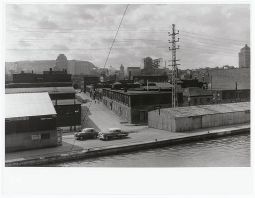
PH1987:0605
PH1987:0605
Personnes et institutions:
Sujet:
architecture, ingénierie
architecture, ingénierie
Date:
1956
1956
Titre:
View of Montréal from the Lachine Canal looking north-west, Montréal, Québec, Canada
Actions:
PH1987:0605
View of Montréal from the Lachine Canal looking north-west, Montréal, Québec, Canada
Actions:
PH1987:0605
Classification:
photographies
photographies
Date:
1956
1956
Personnes et institutions:
Sujet:
architecture, ingénierie
architecture, ingénierie
Niveau de description archivistique:
Projet
Projet
Numéro de référence:
AP041.S1.1987.D1
Description:
The project series documents for Melvin Charney's design for the Canadian Centre for Architecture's garden in Montréal, Québec, realized between 1987 and 1995. The project series includes conceptual, presentation and working drawings, a presentation model and photographs showing the garden under construction and completed.
Personnes et institutions:
Date:
1987-1995
1987-1995
Titre:
Garden of the Canadian Centre for Architecture, Montréal, Québec
Actions:
AP041.S1.1987.D1
Description:
The project series documents for Melvin Charney's design for the Canadian Centre for Architecture's garden in Montréal, Québec, realized between 1987 and 1995. The project series includes conceptual, presentation and working drawings, a presentation model and photographs showing the garden under construction and completed.
Niveau de description archivistique:
Project
Project
Date:
1987-1995
1987-1995
Personnes et institutions:
Classification:
photographies
photographies
Actions:
Numéro de référence:
PH2012:0001:005
PH2012:0001:005
Personnes et institutions:
Date:
circa 1965-1966
circa 1965-1966
Titre:
View of studio camera for video text, Université de Montréal, Montréal, Québec, Canada
Actions:
PH2012:0001:005
View of studio camera for video text, Université de Montréal, Montréal, Québec, Canada
Actions:
PH2012:0001:005
Classification:
photographies
photographies
Date:
circa 1965-1966
circa 1965-1966
Personnes et institutions:
Classification:
photographies
photographies
Numéro de référence:
ARCH255797
ARCH255797
Personnes et institutions:
Date:
1966-1967
1966-1967
Classification:
photographies
photographies
Date:
1966-1967
1966-1967
Personnes et institutions: