6037 Résultats
Classification:
dessins
dessins
Numéro de référence:
AP082.S1.061
Description:
Panels numbered HQ/PB 68, 71, 75-76, 78, 80-81. Two panels are undated.
AP082.S1.061
Description:
Panels numbered HQ/PB 68, 71, 75-76, 78, 80-81. Two panels are undated.
Personnes et institutions:
Date:
1997
1997
Titre:
Universal Headquarters Building, Universal City, Los Angeles County, California: presentation drawings.
Actions:
AP082.S1.061
Description:
Panels numbered HQ/PB 68, 71, 75-76, 78, 80-81. Two panels are undated.
Universal Headquarters Building, Universal City, Los Angeles County, California: presentation drawings.
Actions:
AP082.S1.061
Description:
Panels numbered HQ/PB 68, 71, 75-76, 78, 80-81. Two panels are undated.
Classification:
dessins
dessins
Date:
1997
1997
Personnes et institutions:
Classification:
dessins
dessins
Numéro de référence:
AP082.S1.062
Description:
HQ/PB 84-85, 91-93, 97. Includes two panels (colour montages) from an unnumbered series.
AP082.S1.062
Description:
HQ/PB 84-85, 91-93, 97. Includes two panels (colour montages) from an unnumbered series.
Personnes et institutions:
Date:
between 1996 and 1997
between 1996 and 1997
Titre:
Universal Headquarters Building, Universal City, Los Angeles County, California: presentation drawings.
Actions:
AP082.S1.062
Description:
HQ/PB 84-85, 91-93, 97. Includes two panels (colour montages) from an unnumbered series.
Universal Headquarters Building, Universal City, Los Angeles County, California: presentation drawings.
Actions:
AP082.S1.062
Description:
HQ/PB 84-85, 91-93, 97. Includes two panels (colour montages) from an unnumbered series.
Classification:
dessins
dessins
Date:
between 1996 and 1997
between 1996 and 1997
Personnes et institutions:
Classification:
dessins
dessins
Numéro de référence:
AP082.S1.063
Description:
Numbered HQ/PB 32, 52A-B, 53-54.
AP082.S1.063
Description:
Numbered HQ/PB 32, 52A-B, 53-54.
Personnes et institutions:
Date:
1997
1997
Titre:
Universal Headquarters Building, Universal City, Los Angeles County, California: presentation drawings.
Actions:
AP082.S1.063
Description:
Numbered HQ/PB 32, 52A-B, 53-54.
Universal Headquarters Building, Universal City, Los Angeles County, California: presentation drawings.
Actions:
AP082.S1.063
Description:
Numbered HQ/PB 32, 52A-B, 53-54.
Classification:
dessins
dessins
Date:
1997
1997
Personnes et institutions:
Classification:
dessins
dessins
Numéro de référence:
DR1987:0585
Description:
- This drawing for an hexagonal-shaped sign for Wayfarers' Chapel, Palos Verdes, California, is developed within the equilateral parallelogram grid unit of the chapel. The grid unit is inscribed on several orthographic drawings (DR1987:0530) and is described by Lloyd Wright in the architect's statement (DR1987:0869:011:009). This sign could either be for the entrance gate sign or the roadside sign shown on other drawings (eg. DR1987:0625).
Personnes et institutions:
Sujet:
architecture
architecture
Date:
between 1953 and 1958
between 1953 and 1958
Titre:
Wayfarers' Chapel, Palos Verdes, California: Elevation for a sign developed within an equilateral parallelogram
Actions:
DR1987:0585
Description:
- This drawing for an hexagonal-shaped sign for Wayfarers' Chapel, Palos Verdes, California, is developed within the equilateral parallelogram grid unit of the chapel. The grid unit is inscribed on several orthographic drawings (DR1987:0530) and is described by Lloyd Wright in the architect's statement (DR1987:0869:011:009). This sign could either be for the entrance gate sign or the roadside sign shown on other drawings (eg. DR1987:0625).
Classification:
dessins
dessins
Date:
between 1953 and 1958
between 1953 and 1958
Personnes et institutions:
Sujet:
architecture
architecture
Classification:
dessins
dessins
Numéro de référence:
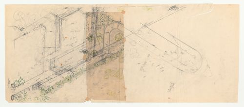
DR1987:0422:001-002
Description:
- This drawing for the site for Swedenborg Memorial Chapel, El Cerrito, California, includes calculations of gradients for the road and the placement of trees along the roadway.
DR1987:0422:001-002
Description:
- This drawing for the site for Swedenborg Memorial Chapel, El Cerrito, California, includes calculations of gradients for the road and the placement of trees along the roadway.
Personnes et institutions:
Sujet:
architecture
architecture
Date:
1959
1959
Titre:
Swedenborg Memorial Chapel, El Cerrito, California: Developmental site plan for the chapel and access road
Actions:
DR1987:0422:001-002
Description:
- This drawing for the site for Swedenborg Memorial Chapel, El Cerrito, California, includes calculations of gradients for the road and the placement of trees along the roadway.
Classification:
dessins
dessins
Date:
1959
1959
Personnes et institutions:
Sujet:
architecture
architecture
Classification:
photographies
photographies
Actions:
Numéro de référence:
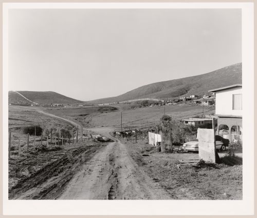
PH1997:0061
Description:
- The series "Running Fence 1997" focuses "on the first 14 miles of the border fence that separates the United States and Mexico, beginning at the Pacific Ocean and ending in the Otay Mountains.... [It] analyzes the "idea" of the border and explores its iconography, the border being a subject that is of extreme importance to the public as the world proceeds towards greater globalization. [Geoffrey] James has written of the project: "[The border fence] was built by the US Army Corps of Engineers in 1994, out of recycled metal landing strip - the most visible symbol of what is known as Operation Gatekeeper. Because the steel sheets are placed in the ground so that their ridges run horizontally, a man can hop over the fence with ease; and no Mexican child ever seems to be impeded from retrieving a soccer ball from US territory. The real barrier to illegal immigration from Mexico into the USA is less visible: hundreds of buried sensors linked to a central computer, nightscopes, helicopters and Border Patrol Agents in white Broncos."" (Evans).
Personnes et institutions:
Sujet:
architecture, ingénierie, topographique
architecture, ingénierie, topographique
Date:
1997
1997
Titre:
View of roads and houses with a partial view of the United States-Mexico border fence, Otay Mesa, San Diego County, California, United States, and Tijuana, Baja California, Mexico
Actions:
PH1997:0061
Description:
- The series "Running Fence 1997" focuses "on the first 14 miles of the border fence that separates the United States and Mexico, beginning at the Pacific Ocean and ending in the Otay Mountains.... [It] analyzes the "idea" of the border and explores its iconography, the border being a subject that is of extreme importance to the public as the world proceeds towards greater globalization. [Geoffrey] James has written of the project: "[The border fence] was built by the US Army Corps of Engineers in 1994, out of recycled metal landing strip - the most visible symbol of what is known as Operation Gatekeeper. Because the steel sheets are placed in the ground so that their ridges run horizontally, a man can hop over the fence with ease; and no Mexican child ever seems to be impeded from retrieving a soccer ball from US territory. The real barrier to illegal immigration from Mexico into the USA is less visible: hundreds of buried sensors linked to a central computer, nightscopes, helicopters and Border Patrol Agents in white Broncos."" (Evans).
Classification:
photographies
photographies
Date:
1997
1997
Personnes et institutions:
Sujet:
architecture, ingénierie, topographique
architecture, ingénierie, topographique
Classification:
dessins
dessins
Numéro de référence:
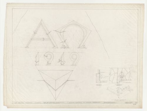
DR1987:0551
Description:
- These drawings are for a time capsule in the wall of Wayfarers' Chapel, Palos Verdes, California. The time capsule is referred to as a "vault" in the inscription on this drawing and in the dedicatory inscription on the cornerstone. The shape and disposition of the inscription plaque is based on the equilateral parallelogram grid unit of the chapel. The grid unit is inscribed on several orthographic drawings (eg. DR1987:0530) and is described by Lloyd Wright in the architect's statement (DR1987:0869:011:009). A small elevation shows the cornerstone in situ.
Personnes et institutions:
Sujet:
architecture
architecture
Date:
12 June 1949
12 June 1949
Titre:
Wayfarers' Chapel, Palos Verdes, California: Elevations and sections for chapel cornerstone and time capsule
Actions:
DR1987:0551
Description:
- These drawings are for a time capsule in the wall of Wayfarers' Chapel, Palos Verdes, California. The time capsule is referred to as a "vault" in the inscription on this drawing and in the dedicatory inscription on the cornerstone. The shape and disposition of the inscription plaque is based on the equilateral parallelogram grid unit of the chapel. The grid unit is inscribed on several orthographic drawings (eg. DR1987:0530) and is described by Lloyd Wright in the architect's statement (DR1987:0869:011:009). A small elevation shows the cornerstone in situ.
Classification:
dessins
dessins
Date:
12 June 1949
12 June 1949
Personnes et institutions:
Sujet:
architecture
architecture
Classification:
dessins
dessins
Numéro de référence:
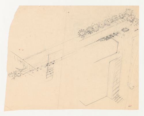
DR1987:0460
Description:
- This partial site plan for Swedenborg Memorial Chapel, El Cerrito, California, gives an incomplete outline of the exterior contours for the building and indicates tree locations along the walkway.
DR1987:0460
Description:
- This partial site plan for Swedenborg Memorial Chapel, El Cerrito, California, gives an incomplete outline of the exterior contours for the building and indicates tree locations along the walkway.
Personnes et institutions:
Sujet:
architecture, architecture de paysage
architecture, architecture de paysage
Date:
between 1955 and 1962
between 1955 and 1962
Titre:
Swedenborg Memorial Chapel, El Cerrito, California: Partial site plan, including trees behind the chapel
Actions:
DR1987:0460
Description:
- This partial site plan for Swedenborg Memorial Chapel, El Cerrito, California, gives an incomplete outline of the exterior contours for the building and indicates tree locations along the walkway.
Classification:
dessins
dessins
Date:
between 1955 and 1962
between 1955 and 1962
Personnes et institutions:
Sujet:
architecture, architecture de paysage
architecture, architecture de paysage
Classification:
dessins
Quantité:
39 reprographic copy(ies)
dessins
Quantité:
39 reprographic copy(ies)
Numéro de référence:
ARCH265322
Description:
This group consists of sections, floor plans, plans, site plans and perspectives for the Pasadena Television Station in Pasadena, California.
ARCH265322
Description:
This group consists of sections, floor plans, plans, site plans and perspectives for the Pasadena Television Station in Pasadena, California.
Personnes et institutions:
Titre:
Sections, floor plans, plans, site plans and perspectives for the Pasadena Television Station in Pasadena, California
Actions:
ARCH265322
Description:
This group consists of sections, floor plans, plans, site plans and perspectives for the Pasadena Television Station in Pasadena, California.
Sections, floor plans, plans, site plans and perspectives for the Pasadena Television Station in Pasadena, California
Actions:
ARCH265322
Description:
This group consists of sections, floor plans, plans, site plans and perspectives for the Pasadena Television Station in Pasadena, California.
Classification:
dessins
Quantité:
39 reprographic copy(ies)
dessins
Quantité:
39 reprographic copy(ies)
Personnes et institutions:
Classification:
photographies
photographies
Actions:
Numéro de référence:
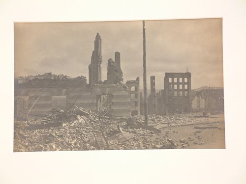
PH1980:0372
PH1980:0372
Personnes et institutions:
Date:
1906
1906
Titre:
General view of the aftermath of the 1906 earthquake and fire, San Francisco, California
Actions:
PH1980:0372
General view of the aftermath of the 1906 earthquake and fire, San Francisco, California
Actions:
PH1980:0372
Classification:
photographies
photographies
Date:
1906
1906
Personnes et institutions: