1048 Results
Level of archival description:
Series
Series
Reference number:
AP119.S1
Description:
The series contains drawings for Peter Yeadon's architectural narrative for the Prix de Rome entitled "Karl: An Architerctural Narrative." In total eleven sets of digital prints were made, each set contains eighteen sheets. Canadian Centre for Architecture received the third of these eleven sets, which is included in this series. The narrative depicts the experience of a Canadian emigrant becoming a Roman citizen. The drawings represent the following titles: City; Fabric House; Columbarium; Horizon House; House City; Depth House; Colosseum for Vanishing Curiosities; City Gate; Teatro de Tevere; Neptune House; Bath; and Bricolage House. Each drawing is signed by the architect. Also included, are four sketchbooks for 'Karl: An Architerctural Narrative', two print proofs for Bricolage House, and project documentation. The documentation explains each of the titles in the narrative, Yeadon's curriculum vitae, and leaflets for the exhibition "Karl: an architectural narrative" held at the Art Gallery of Windsor, Ontario from August 2001 to January 2002.
People:
Date:
1998-2002
1998-2002
Title:
Karl: An Architectural Narrative (2000-2002)
Actions:
AP119.S1
Description:
The series contains drawings for Peter Yeadon's architectural narrative for the Prix de Rome entitled "Karl: An Architerctural Narrative." In total eleven sets of digital prints were made, each set contains eighteen sheets. Canadian Centre for Architecture received the third of these eleven sets, which is included in this series. The narrative depicts the experience of a Canadian emigrant becoming a Roman citizen. The drawings represent the following titles: City; Fabric House; Columbarium; Horizon House; House City; Depth House; Colosseum for Vanishing Curiosities; City Gate; Teatro de Tevere; Neptune House; Bath; and Bricolage House. Each drawing is signed by the architect. Also included, are four sketchbooks for 'Karl: An Architerctural Narrative', two print proofs for Bricolage House, and project documentation. The documentation explains each of the titles in the narrative, Yeadon's curriculum vitae, and leaflets for the exhibition "Karl: an architectural narrative" held at the Art Gallery of Windsor, Ontario from August 2001 to January 2002.
Level of archival description:
Series
Series
Date:
1998-2002
1998-2002
People:
Actions:
Reference number:
ARCH256975
Description:
''to Arthur Erickson whose mind and work make new horizons.''
ARCH256975
Description:
''to Arthur Erickson whose mind and work make new horizons.''
People:
Date:
1967
1967
Title:
Molson Prize of Canada Council
Actions:
ARCH256975
Description:
''to Arthur Erickson whose mind and work make new horizons.''
Molson Prize of Canada Council
Actions:
ARCH256975
Description:
''to Arthur Erickson whose mind and work make new horizons.''
Date:
1967
1967
People:
Form:
photographs
photographs
Actions:
Reference number:
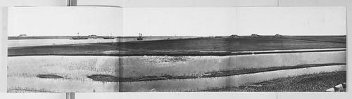
PH1986:0901:014:001-003
Description:
- This panorama is one in a series of views which Felice Beato made of the four Taku Forts (Harris, p. 139; Worswick, p. 138). - This panorama was made from the upper South Taku Fort looking east across the Pei (now Hai) River toward the Gulf of Chihli (now Bo Hai). The British and French combined fleet is visible on the horizon in PH1986:0901:014:002 (Harris, p. 160).
People:
Subject:
architecture, engineering, military, topographic
architecture, engineering, military, topographic
Date:
between 22 August and 21 September 1860
between 22 August and 21 September 1860
Title:
Panorama showing the Pei (now Hai) River delta, with the Lower North Taku Fort (also known as the 2nd North Fort) and the Great South Taku Fort in the background, Taku (now Dagu), near Tientsin (now Tianjin), China
Actions:
PH1986:0901:014:001-003
Description:
- This panorama is one in a series of views which Felice Beato made of the four Taku Forts (Harris, p. 139; Worswick, p. 138). - This panorama was made from the upper South Taku Fort looking east across the Pei (now Hai) River toward the Gulf of Chihli (now Bo Hai). The British and French combined fleet is visible on the horizon in PH1986:0901:014:002 (Harris, p. 160).
Form:
photographs
photographs
Date:
between 22 August and 21 September 1860
between 22 August and 21 September 1860
People:
Subject:
architecture, engineering, military, topographic
architecture, engineering, military, topographic
Form:
photographs
photographs
Actions:
Reference number:
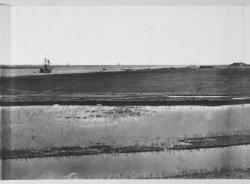
PH1986:0901:014:001
Description:
- This photograph is one in a series of views which Felice Beato made of the four Taku Forts (Harris, p. 139; Worswick, p. 138). - This photograph was made from the upper South Taku Fort looking east across the Pei (now Hai) River toward the Gulf of Chihli (now Bo Hai). The British and French combined fleet is visible on the horizon in PH1986:0901:014:002 (Harris, p. 160).
People:
Subject:
architecture, engineering, military, topographic
architecture, engineering, military, topographic
Date:
between 22 August and 21 September 1860
between 22 August and 21 September 1860
Title:
View showing the Pei (now Hai) River delta, with the Lower North Taku Fort (also known as the 2nd North Fort) in the background, Taku (now Dagu), near Tientsin (now Tianjin), China
Actions:
PH1986:0901:014:001
Description:
- This photograph is one in a series of views which Felice Beato made of the four Taku Forts (Harris, p. 139; Worswick, p. 138). - This photograph was made from the upper South Taku Fort looking east across the Pei (now Hai) River toward the Gulf of Chihli (now Bo Hai). The British and French combined fleet is visible on the horizon in PH1986:0901:014:002 (Harris, p. 160).
Form:
photographs
photographs
Date:
between 22 August and 21 September 1860
between 22 August and 21 September 1860
People:
Subject:
architecture, engineering, military, topographic
architecture, engineering, military, topographic
Form:
photographs
photographs
Actions:
Reference number:
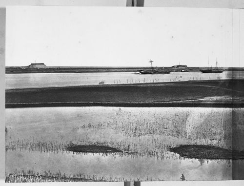
PH1986:0901:014:002
Description:
- This photograph is one in a series of views which Felice Beato made of the four Taku Forts (Harris, p. 139; Worswick, p. 138). - This photograph was made from the upper South Taku Fort looking east across the Pei (now Hai) River toward the Gulf of Chihli (now Bo Hai). The British and French combined fleet is visible on the horizon in PH1986:0901:014:002 (Harris, p. 160).
People:
Subject:
architecture, engineering, military, topographic
architecture, engineering, military, topographic
Date:
between 22 August and 21 September 1860
between 22 August and 21 September 1860
Title:
View showing the Pei (now Hai) River delta, with part of the Great South Taku Fort in the background, Taku (now Dagu), near Tientsin (now Tianjin), China
Actions:
PH1986:0901:014:002
Description:
- This photograph is one in a series of views which Felice Beato made of the four Taku Forts (Harris, p. 139; Worswick, p. 138). - This photograph was made from the upper South Taku Fort looking east across the Pei (now Hai) River toward the Gulf of Chihli (now Bo Hai). The British and French combined fleet is visible on the horizon in PH1986:0901:014:002 (Harris, p. 160).
Form:
photographs
photographs
Date:
between 22 August and 21 September 1860
between 22 August and 21 September 1860
People:
Subject:
architecture, engineering, military, topographic
architecture, engineering, military, topographic
Form:
photographs
photographs
Actions:
Reference number:
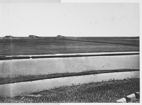
PH1986:0901:014:003
Description:
- This photograph is one in a series of views which Felice Beato made of the four Taku Forts (Harris, p. 139; Worswick, p. 138). - This photograph was made from the upper South Taku Fort looking east across the Pei (now Hai) River toward the Gulf of Chihli (now Bo Hai). The British and French combined fleet is visible on the horizon in PH1986:0901:014:002 (Harris, p. 160).
People:
Subject:
architecture, engineering, military, topographic
architecture, engineering, military, topographic
Date:
between 22 August and 21 September 1860
between 22 August and 21 September 1860
Title:
View showing the Pei (now Hai) River delta, with part of the Great South Taku Fort in the background, Taku (now Dagu), near Tientsin (now Tianjin), China
Actions:
PH1986:0901:014:003
Description:
- This photograph is one in a series of views which Felice Beato made of the four Taku Forts (Harris, p. 139; Worswick, p. 138). - This photograph was made from the upper South Taku Fort looking east across the Pei (now Hai) River toward the Gulf of Chihli (now Bo Hai). The British and French combined fleet is visible on the horizon in PH1986:0901:014:002 (Harris, p. 160).
Form:
photographs
photographs
Date:
between 22 August and 21 September 1860
between 22 August and 21 September 1860
People:
Subject:
architecture, engineering, military, topographic
architecture, engineering, military, topographic
Level of archival description:
Project
Project
Reference number:
AP164.S1.1999.D10
Description:
The project series documents the competition entry for the mixed-use tower “El Mirador” in the Bay of Algeciras. The firm was invited to submit their design proposal which won second prize. The competition was organised by the Algeciras City Council. The firm identified this project as number 123. “The project attempts to express, with an architectural gesture, the beauty of the geography of Algeciras: the bay, the port, the Rock and the Straits of Gibraltar, the proximity of Ceuta and Africa, the cork-oak forests that surround the town. For this [Abalos & Herreros] propose a building that, from a single body, opens out into two towers from one great public viewing platform. This form has strategic holes giving onto the more notable topographical features, establishing a physical relationship with them, while the section is organized as a gradient of privacy that increases with height. The competition […] proposed a mixed programme in a posture parallel to the great avenue of the harbour of Algeciras. An evanescent building apparently fragile appears to let one being stimulated by the effects of the climate and the atmospheric phenomenons with an appearance changing with the function of the hours of the day or the season. Its layered section attends ascending to the different landscapes of the city: first public space, second the cities skyline and at last the 360° horizon rising above the city.” (ARCH270975) Abalos & Herreros worked with Ángel Jaramillo, Renata Sentkiewicz, Jakob Hense. Documenting this project are conceptual, design development and presentation drawings, cartographic and graphic materials, and competition records.
People:
Date:
circa 1999
circa 1999
Title:
El mirador: torre mixta en la Bahía de Algeciras, Spain (1999)
Actions:
AP164.S1.1999.D10
Description:
The project series documents the competition entry for the mixed-use tower “El Mirador” in the Bay of Algeciras. The firm was invited to submit their design proposal which won second prize. The competition was organised by the Algeciras City Council. The firm identified this project as number 123. “The project attempts to express, with an architectural gesture, the beauty of the geography of Algeciras: the bay, the port, the Rock and the Straits of Gibraltar, the proximity of Ceuta and Africa, the cork-oak forests that surround the town. For this [Abalos & Herreros] propose a building that, from a single body, opens out into two towers from one great public viewing platform. This form has strategic holes giving onto the more notable topographical features, establishing a physical relationship with them, while the section is organized as a gradient of privacy that increases with height. The competition […] proposed a mixed programme in a posture parallel to the great avenue of the harbour of Algeciras. An evanescent building apparently fragile appears to let one being stimulated by the effects of the climate and the atmospheric phenomenons with an appearance changing with the function of the hours of the day or the season. Its layered section attends ascending to the different landscapes of the city: first public space, second the cities skyline and at last the 360° horizon rising above the city.” (ARCH270975) Abalos & Herreros worked with Ángel Jaramillo, Renata Sentkiewicz, Jakob Hense. Documenting this project are conceptual, design development and presentation drawings, cartographic and graphic materials, and competition records.
Level of archival description:
Project
Project
Date:
circa 1999
circa 1999
People:
Form:
events
events
Title:
Learning from... London
Learning from... London
Actions:
Description:
Kieran Long presents a story about the difficulty of describing a city in all its richness. London contains stories and meanings that are alive to its citizens, but apparently too difficult to talk about, too rich, and too messy to be allowed to affect those who decide how the city changes. The deafness of developers, politicians and architects to these narratives is so(...)
Kieran Long presents a story about the difficulty of describing a city in all its richness. London contains stories and meanings that are alive to its citizens, but apparently too difficult to talk about, too rich, and too messy to be allowed to affect those who decide how the city changes. The deafness of developers, politicians and architects to these narratives is so(...)
Location:
Paul Desmarais Theater
Paul Desmarais Theater
Date:
10 March 2011 , 7pm
10 March 2011 , 7pm
Title:
Learning from... London
Actions:
Description:
Kieran Long presents a story about the difficulty of describing a city in all its richness. London contains stories and meanings that are alive to its citizens, but apparently too difficult to talk about, too rich, and too messy to be allowed to affect those who decide how the city changes. The deafness of developers, politicians and architects to these narratives is so(...)
Form:
events
events
Date:
10 March 2011
7pm
10 March 2011
7pm
Location:
Paul Desmarais Theater
Paul Desmarais Theater
Form:
events
events
Actions:
Description:
Michelangelo Sabatino, 2011 Visiting Scholar, offers an overview of Arthur Erickson’s contribution to shaping the city of the 20th century, drawn from his forthcoming book Arthur Erickson : Architectural Environments. Click here for the Facebook event.
Michelangelo Sabatino, 2011 Visiting Scholar, offers an overview of Arthur Erickson’s contribution to shaping the city of the 20th century, drawn from his forthcoming book Arthur Erickson : Architectural Environments. Click here for the Facebook event.
Location:
Shaughnessy House
Presented in English Keyword(s):
Michelangelo Sabatino, visiting scholar seminar
Shaughnessy House
Presented in English Keyword(s):
Michelangelo Sabatino, visiting scholar seminar
Date:
11 August 2011, 6pm
11 August 2011, 6pm
Title:
Visiting Scholar Seminar: Michelangelo Sabatino
Actions:
Description:
Michelangelo Sabatino, 2011 Visiting Scholar, offers an overview of Arthur Erickson’s contribution to shaping the city of the 20th century, drawn from his forthcoming book Arthur Erickson : Architectural Environments. Click here for the Facebook event.
Form:
events
events
Date:
11 August 2011
6pm
11 August 2011
6pm
Location:
Shaughnessy House
Presented in English Keyword(s):
Michelangelo Sabatino, visiting scholar seminar
Shaughnessy House
Presented in English Keyword(s):
Michelangelo Sabatino, visiting scholar seminar
Form:
drawings
Quantity:
2 presentation drawing(s)
drawings
Quantity:
2 presentation drawing(s)
Reference number:
AP140.S2.SS1.D9.P1
Description:
one drawing shows plans, elevations, cross sections and longitudinal sections for terraces of staggered houses, cross sections for houses, plans for a large detached house, plans for a typical three-bedroom house, a diagrammatic cross section for a house showing the 10 1/2 feet and 7 feet horizon tall modules, the 7 feet vertical modules, and the 30 degrees sloped roofs, a diagrammatic cross section for the structure, a diagrammatic plan for grouped houses, a sequence of two axonometric drawings representing the system of construction, from the parallel load-bearing walls to finished building, and explanatory typescript texts; a hand-coloured drawing shows a roadside elevation and a sectional elevation for a terrace of staggered houses and was probably part of a no longer extant final presentation drawing for the CIAM X Congress
People:
Date:
1955
1955
Title:
Plans, elevations, cross sections and longitudinal sections for terraces of staggered houses
Actions:
AP140.S2.SS1.D9.P1
Description:
one drawing shows plans, elevations, cross sections and longitudinal sections for terraces of staggered houses, cross sections for houses, plans for a large detached house, plans for a typical three-bedroom house, a diagrammatic cross section for a house showing the 10 1/2 feet and 7 feet horizon tall modules, the 7 feet vertical modules, and the 30 degrees sloped roofs, a diagrammatic cross section for the structure, a diagrammatic plan for grouped houses, a sequence of two axonometric drawings representing the system of construction, from the parallel load-bearing walls to finished building, and explanatory typescript texts; a hand-coloured drawing shows a roadside elevation and a sectional elevation for a terrace of staggered houses and was probably part of a no longer extant final presentation drawing for the CIAM X Congress
Form:
drawings
Quantity:
2 presentation drawing(s)
drawings
Quantity:
2 presentation drawing(s)
Date:
1955
1955
People: