35108 Results
Level of archival description:
Sub-series
Sub-series
Actions:
Reference number:
AP032.S2.SS2.D2.SD16
Description:
This subseries documents plan revisions for a project in Indiana from 1983 and the records consists of maps, sketches, and project notes.
AP032.S2.SS2.D2.SD16
Description:
This subseries documents plan revisions for a project in Indiana from 1983 and the records consists of maps, sketches, and project notes.
People:
Date:
1983
1983
Title:
Colombus, Indiana, Master Plan Revisions
Actions:
AP032.S2.SS2.D2.SD16
Description:
This subseries documents plan revisions for a project in Indiana from 1983 and the records consists of maps, sketches, and project notes.
Colombus, Indiana, Master Plan Revisions
Actions:
AP032.S2.SS2.D2.SD16
Description:
This subseries documents plan revisions for a project in Indiana from 1983 and the records consists of maps, sketches, and project notes.
Level of archival description:
Sub-file 16
Sub-file 16
Date:
1983
1983
People:
Form:
drawings
Quantity:
6 presentation panel(s)
drawings
Quantity:
6 presentation panel(s)
Actions:
Reference number:
DR1995:0167:109-114
Description:
Panels show elevations, plans, sections, details, map, view of site and diagram.
DR1995:0167:109-114
Description:
Panels show elevations, plans, sections, details, map, view of site and diagram.
People:
Title:
Presentation panels for Oldham Town Centre thesis project
Actions:
DR1995:0167:109-114
Description:
Panels show elevations, plans, sections, details, map, view of site and diagram.
Presentation panels for Oldham Town Centre thesis project
Actions:
DR1995:0167:109-114
Description:
Panels show elevations, plans, sections, details, map, view of site and diagram.
Form:
drawings
Quantity:
6 presentation panel(s)
drawings
Quantity:
6 presentation panel(s)
People:
Form:
drawings, textual records
drawings, textual records
Actions:
Reference number:
ARCH278052
Description:
File's title: Curriculum: concurso Biblioteca nacional Mexico. Contains a map as well.
ARCH278052
Description:
File's title: Curriculum: concurso Biblioteca nacional Mexico. Contains a map as well.
People:
Date:
2001, 2003, predominant 2003
2001, 2003, predominant 2003
Title:
Abalos & Herreros and ARUP's resumes, correspondence, and sketches, Biblioteca de México, Mexico City
Actions:
ARCH278052
Description:
File's title: Curriculum: concurso Biblioteca nacional Mexico. Contains a map as well.
Abalos & Herreros and ARUP's resumes, correspondence, and sketches, Biblioteca de México, Mexico City
Actions:
ARCH278052
Description:
File's title: Curriculum: concurso Biblioteca nacional Mexico. Contains a map as well.
Form:
drawings, textual records
drawings, textual records
Date:
2001, 2003, predominant 2003
2001, 2003, predominant 2003
People:
Form:
textual records
textual records
Reference number:
ARCH153561
Description:
Handwritten notes on yellow paper: analysis of the map of the city, population, history, etc. Street Project, Meeting of September 25 1970; "Attempt at a definition of 'Compartmentalization'', Betsy Cromley Texaco map of Kansas City
ARCH153561
Description:
Handwritten notes on yellow paper: analysis of the map of the city, population, history, etc. Street Project, Meeting of September 25 1970; "Attempt at a definition of 'Compartmentalization'', Betsy Cromley Texaco map of Kansas City
People:
Date:
1970
1970
Title:
IAUS Kansas City [street project], 1970
Actions:
ARCH153561
Description:
Handwritten notes on yellow paper: analysis of the map of the city, population, history, etc. Street Project, Meeting of September 25 1970; "Attempt at a definition of 'Compartmentalization'', Betsy Cromley Texaco map of Kansas City
Form:
textual records
textual records
Date:
1970
1970
People:
Form:
textual records
textual records
Actions:
Reference number:
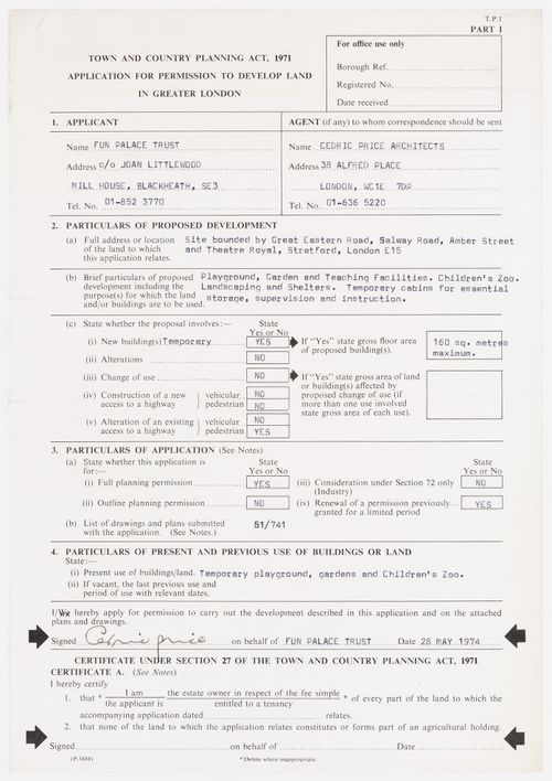
DR1995:0188:538
Description:
Includes: 1 application form (2 pages), 1 notice and 1 map of London
DR1995:0188:538
Description:
Includes: 1 application form (2 pages), 1 notice and 1 map of London
People:
Date:
1974
1974
Title:
Application by the Fun Palace Trust to obtain permission to develop land in Greater London
Actions:
DR1995:0188:538
Description:
Includes: 1 application form (2 pages), 1 notice and 1 map of London
Application by the Fun Palace Trust to obtain permission to develop land in Greater London
Actions:
DR1995:0188:538
Description:
Includes: 1 application form (2 pages), 1 notice and 1 map of London
Form:
textual records
textual records
Date:
1974
1974
People:
Form:
maps, textual records
maps, textual records
Title:
Blackfriars
Blackfriars
Actions:
Reference number:
DR2004:1377
Description:
a memorandum, a map, and photocopies of various published articles on buildings in Blackfriars
DR2004:1377
Description:
a memorandum, a map, and photocopies of various published articles on buildings in Blackfriars
People:
Date:
1983, 1994
1983, 1994
Title:
Blackfriars
Actions:
DR2004:1377
Description:
a memorandum, a map, and photocopies of various published articles on buildings in Blackfriars
Blackfriars
Actions:
DR2004:1377
Description:
a memorandum, a map, and photocopies of various published articles on buildings in Blackfriars
Form:
maps, textual records
maps, textual records
Date:
1983, 1994
1983, 1994
People:
Form:
drawings
Quantity:
13 reprographic copy(ies)
drawings
Quantity:
13 reprographic copy(ies)
Reference number:
ARCH268459
Description:
This group is composed of an information sheet, a site map, plans and elevations.
ARCH268459
Description:
This group is composed of an information sheet, a site map, plans and elevations.
People:
Title:
Galaxy final (drawings numbered 1-13)
Actions:
ARCH268459
Description:
This group is composed of an information sheet, a site map, plans and elevations.
Galaxy final (drawings numbered 1-13)
Actions:
ARCH268459
Description:
This group is composed of an information sheet, a site map, plans and elevations.
Form:
drawings
Quantity:
13 reprographic copy(ies)
drawings
Quantity:
13 reprographic copy(ies)
People:
Form:
drawings, textual records
drawings, textual records
Actions:
Reference number:
AP178.S1.1999.PR08.003.2
Description:
Original file title: Sabadell levantamentos regulamentosx This file includes regulations about the buildings accessibility regulation, a map of Sedabell, and cadastral maps.
AP178.S1.1999.PR08.003.2
Description:
Original file title: Sabadell levantamentos regulamentosx This file includes regulations about the buildings accessibility regulation, a map of Sedabell, and cadastral maps.
People:
Date:
circa 1996-1999
circa 1996-1999
Title:
Project documentation, plans, and photographs of models, Projecto de Ordenación nel Âmbito del Vapor Turull, Sabadell (folder 3 of 2)
Actions:
AP178.S1.1999.PR08.003.2
Description:
Original file title: Sabadell levantamentos regulamentosx This file includes regulations about the buildings accessibility regulation, a map of Sedabell, and cadastral maps.
Form:
drawings, textual records
drawings, textual records
Date:
circa 1996-1999
circa 1996-1999
People:
Level of archival description:
Project
Project
Actions:
Reference number:
AP144.S2.D16
Description:
File documents the project Theory of Centrality (East Anglia), England. Undated drawings are of a regional map of East Anglia showing existing transportation networks and towns, as well as additions, possibly of a secondary transportation network, nodal points between towns, and other regional development. Further research is required to establish the scope of this project. Material in this file was probably produced between 1960 and 1985. File contains reference and conceptual drawings.
People:
Date:
[1960?-1985?]
[1960?-1985?]
Title:
Theory of Centrality (East Anglia)
Actions:
AP144.S2.D16
Description:
File documents the project Theory of Centrality (East Anglia), England. Undated drawings are of a regional map of East Anglia showing existing transportation networks and towns, as well as additions, possibly of a secondary transportation network, nodal points between towns, and other regional development. Further research is required to establish the scope of this project. Material in this file was probably produced between 1960 and 1985. File contains reference and conceptual drawings.
Level of archival description:
File 16
File 16
Date:
[1960?-1985?]
[1960?-1985?]
People:
Form:
drawings
drawings
Actions:
Reference number:
ARCH259463
Description:
information on the site of St. Peter's Evangelical Church, Ottawa - aerial photograph indicating the site, map of central Ottawa area, street / site maps
ARCH259463
Description:
information on the site of St. Peter's Evangelical Church, Ottawa - aerial photograph indicating the site, map of central Ottawa area, street / site maps
People:
Title:
Information on the site of St. Peter's Evangelical Church
Actions:
ARCH259463
Description:
information on the site of St. Peter's Evangelical Church, Ottawa - aerial photograph indicating the site, map of central Ottawa area, street / site maps
Information on the site of St. Peter's Evangelical Church
Actions:
ARCH259463
Description:
information on the site of St. Peter's Evangelical Church, Ottawa - aerial photograph indicating the site, map of central Ottawa area, street / site maps
Form:
drawings
drawings
People: