35106 Results
Form:
drawings
drawings
Actions:
Reference number:
AP140.S2.SS1.D4.P1
Description:
Outline map of the south-east area of the town of Poole showing the location of the site and two buildings of the College, and directions of views across the coastline
AP140.S2.SS1.D4.P1
Description:
Outline map of the south-east area of the town of Poole showing the location of the site and two buildings of the College, and directions of views across the coastline
People:
Date:
circa 1951-1975
circa 1951-1975
Title:
Map showing the site and the of the College, Poole College of Further Education Competition, Poole, United Kingdom
Actions:
AP140.S2.SS1.D4.P1
Description:
Outline map of the south-east area of the town of Poole showing the location of the site and two buildings of the College, and directions of views across the coastline
Form:
drawings
drawings
Date:
circa 1951-1975
circa 1951-1975
People:
Form:
maps, drawings
maps, drawings

Title:
Scaled map of the coast of France, with locations of major cities in France and western Europe
Scaled map of the coast of France, with locations of major cities in France and western Europe
Actions:
Reference number:
DR1974:0002:001:002
DR1974:0002:001:002
People:
Subject:
topographic
topographic
Date:
1822
1822
Title:
Scaled map of the coast of France, with locations of major cities in France and western Europe
Actions:
DR1974:0002:001:002
Scaled map of the coast of France, with locations of major cities in France and western Europe
Actions:
DR1974:0002:001:002
Form:
maps, drawings
maps, drawings
Date:
1822
1822
People:
Subject:
topographic
topographic
Form:
drawings
drawings
Actions:
Reference number:
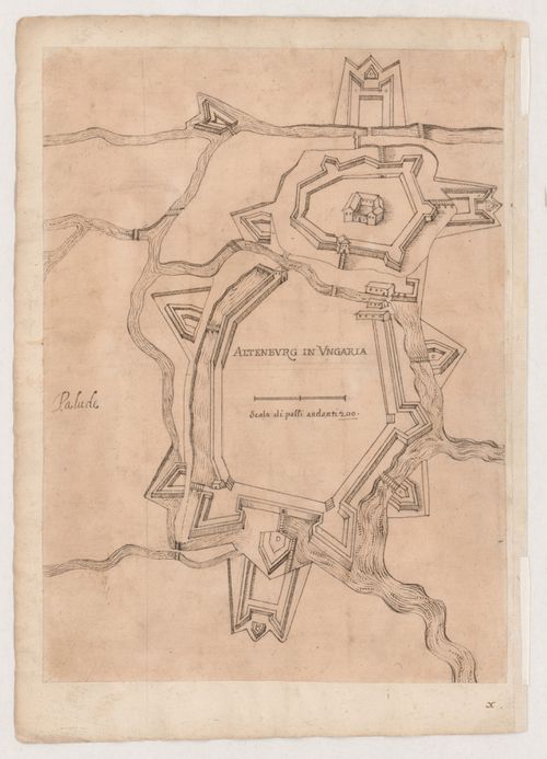
DR1981:0017:073 R/V
DR1981:0017:073 R/V
People:
Subject:
architecture
architecture
Date:
circa 1630-1640; verso: 1644
circa 1630-1640; verso: 1644
Title:
Schematic drawing of the fortifications at Altenberg, Hungary; verso: Map of the mouth of the Po River
Actions:
DR1981:0017:073 R/V
Schematic drawing of the fortifications at Altenberg, Hungary; verso: Map of the mouth of the Po River
Actions:
DR1981:0017:073 R/V
Form:
drawings
drawings
Date:
circa 1630-1640; verso: 1644
circa 1630-1640; verso: 1644
People:
Subject:
architecture
architecture
Form:
textual records
textual records
Title:
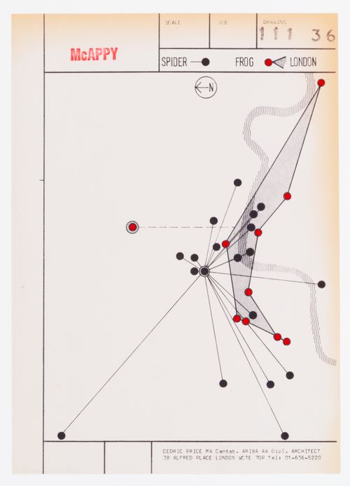
McAppy: map showing "spider" and "frog" patterns of large and small jobs in the London Region
McAppy: map showing "spider" and "frog" patterns of large and small jobs in the London Region
Actions:
Reference number:
DR1995:0263:032:005:004
DR1995:0263:032:005:004
People:
Date:
between 1973 and 1975
between 1973 and 1975
Title:
McAppy: map showing "spider" and "frog" patterns of large and small jobs in the London Region
Actions:
DR1995:0263:032:005:004
McAppy: map showing "spider" and "frog" patterns of large and small jobs in the London Region
Actions:
DR1995:0263:032:005:004
Form:
textual records
textual records
Date:
between 1973 and 1975
between 1973 and 1975
People:
Form:
drawings
drawings
Actions:
Reference number:
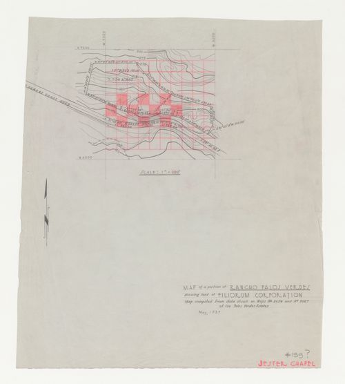
DR1987:0567
Description:
- This graphite drawing of the contour lines and topographical features of the property held by the Filiorum Corporation on the Palos Verdes estates shows the future site for Wayfarers' Chapel. The graphite drawing is partitioned with a square grid, which was possibly drawn by a member of Lloyd Wright's office, because it is in the same media as the inscription "JESTER CHAPEL", one of the early names used by the architect for the project.
People:
Subject:
architecture, topographic
architecture, topographic
Date:
May 1937
May 1937
Title:
Wayfarers' Chapel, Palos Verdes, California: Contour map of Filiorum Corporation property, including chapel site
Actions:
DR1987:0567
Description:
- This graphite drawing of the contour lines and topographical features of the property held by the Filiorum Corporation on the Palos Verdes estates shows the future site for Wayfarers' Chapel. The graphite drawing is partitioned with a square grid, which was possibly drawn by a member of Lloyd Wright's office, because it is in the same media as the inscription "JESTER CHAPEL", one of the early names used by the architect for the project.
Form:
drawings
drawings
Date:
May 1937
May 1937
People:
Subject:
architecture, topographic
architecture, topographic
Form:
drawings
drawings
Actions:
Reference number:
ARCH400735
ARCH400735
People:
Date:
1962
1962
Form:
drawings
drawings
Date:
1962
1962
People:
Form:
textual records
textual records
Actions:
Reference number:
AP142.S1.D146.P1
AP142.S1.D146.P1
People:
Form:
textual records
textual records
People:
Form:
drawings
drawings
Title:
South office level plans, typical office section and plan, mosque plaza plan, topographical map
South office level plans, typical office section and plan, mosque plaza plan, topographical map
Actions:
Reference number:
ARCH261592
ARCH261592
People:
Date:
circa 1947-2002
circa 1947-2002
Form:
drawings
drawings
Date:
circa 1947-2002
circa 1947-2002
People:
Form:
drawings
Quantity:
2 presentation panel(s)
drawings
Quantity:
2 presentation panel(s)
Reference number:
DR2004:0988
DR2004:0988
People:
Form:
drawings
Quantity:
2 presentation panel(s)
drawings
Quantity:
2 presentation panel(s)
People:
Form:
textual records
textual records
Actions:
Reference number:
ARCH257385
ARCH257385
People:
Date:
1988-1990
1988-1990
Form:
textual records
textual records
Date:
1988-1990
1988-1990
People: