


31793 Results
Form:
photographs
photographs
Actions:
Reference number:
PH1980:0048.02:005
Description:
- Suzanne K. Williamson indicates that this photograph shows the southwestern enclosure and tower "M" of the Crusader Castle in Beaufort, Ottoman Empire (now Lebanon) (Oct. 1986). Further research should include verification of this information and identification of the source(s) from which it was obtained. The cardinal point indicated in the title, also provided by Williamson, is presumed to be correct.
PH1980:0048.02:005
Description:
- Suzanne K. Williamson indicates that this photograph shows the southwestern enclosure and tower "M" of the Crusader Castle in Beaufort, Ottoman Empire (now Lebanon) (Oct. 1986). Further research should include verification of this information and identification of the source(s) from which it was obtained. The cardinal point indicated in the title, also provided by Williamson, is presumed to be correct.
People:
Subject:
architecture, military
architecture, military
Date:
1859-1860
1859-1860
Title:
View of the Crusader Castle showing the southwestern enclosure, Beaufort, Ottoman Empire (now in Lebanon)
Actions:
PH1980:0048.02:005
Description:
- Suzanne K. Williamson indicates that this photograph shows the southwestern enclosure and tower "M" of the Crusader Castle in Beaufort, Ottoman Empire (now Lebanon) (Oct. 1986). Further research should include verification of this information and identification of the source(s) from which it was obtained. The cardinal point indicated in the title, also provided by Williamson, is presumed to be correct.
View of the Crusader Castle showing the southwestern enclosure, Beaufort, Ottoman Empire (now in Lebanon)
Actions:
PH1980:0048.02:005
Description:
- Suzanne K. Williamson indicates that this photograph shows the southwestern enclosure and tower "M" of the Crusader Castle in Beaufort, Ottoman Empire (now Lebanon) (Oct. 1986). Further research should include verification of this information and identification of the source(s) from which it was obtained. The cardinal point indicated in the title, also provided by Williamson, is presumed to be correct.
Form:
photographs
photographs
Date:
1859-1860
1859-1860
People:
Subject:
architecture, military
architecture, military
Form:
photographs
photographs
Actions:
Reference number:
PH1986:0464:010
Description:
An index to the heliogravures appears in the front of the album. Heliogravures PH1986:0464:005 and PH1986:0464:006 which are printed on the same sheet, are both numbered "V". The last heliogravure titled "XVI. Le Croiseur "Pamiat Merkouria" à Sewastopol." has been disbound from the album and is missing. The Beklemishevskaya Tower appears at the right of the photograph.
PH1986:0464:010
Description:
An index to the heliogravures appears in the front of the album. Heliogravures PH1986:0464:005 and PH1986:0464:006 which are printed on the same sheet, are both numbered "V". The last heliogravure titled "XVI. Le Croiseur "Pamiat Merkouria" à Sewastopol." has been disbound from the album and is missing. The Beklemishevskaya Tower appears at the right of the photograph.
People:
Subject:
architecture
architecture
Date:
before 1896
before 1896
Title:
View of the Kremlin showing the reconstruction of the Beklemishevskaya Tower, Moscow
Actions:
PH1986:0464:010
Description:
An index to the heliogravures appears in the front of the album. Heliogravures PH1986:0464:005 and PH1986:0464:006 which are printed on the same sheet, are both numbered "V". The last heliogravure titled "XVI. Le Croiseur "Pamiat Merkouria" à Sewastopol." has been disbound from the album and is missing. The Beklemishevskaya Tower appears at the right of the photograph.
View of the Kremlin showing the reconstruction of the Beklemishevskaya Tower, Moscow
Actions:
PH1986:0464:010
Description:
An index to the heliogravures appears in the front of the album. Heliogravures PH1986:0464:005 and PH1986:0464:006 which are printed on the same sheet, are both numbered "V". The last heliogravure titled "XVI. Le Croiseur "Pamiat Merkouria" à Sewastopol." has been disbound from the album and is missing. The Beklemishevskaya Tower appears at the right of the photograph.
Form:
photographs
photographs
Date:
before 1896
before 1896
People:
Subject:
architecture
architecture
Form:
photographs
photographs
Reference number:
PH1986:0464:011
Description:
An index to the heliogravures appears in the front of the album. Heliogravures PH1986:0464:005 and PH1986:0464:006 which are printed on the same sheet, are both numbered "V". The last heliogravure titled "XVI. Le Croiseur "Pamiat Merkouria" à Sewastopol." has been disbound from the album and is missing. The Beklemishevskaya Tower appears at the right of the photograph.
PH1986:0464:011
Description:
An index to the heliogravures appears in the front of the album. Heliogravures PH1986:0464:005 and PH1986:0464:006 which are printed on the same sheet, are both numbered "V". The last heliogravure titled "XVI. Le Croiseur "Pamiat Merkouria" à Sewastopol." has been disbound from the album and is missing. The Beklemishevskaya Tower appears at the right of the photograph.
People:
Subject:
architecture
architecture
Date:
before 1896
before 1896
Title:
View of the Kremlin showing the Beklemishevskaya Tower, Moscow
Actions:
PH1986:0464:011
Description:
An index to the heliogravures appears in the front of the album. Heliogravures PH1986:0464:005 and PH1986:0464:006 which are printed on the same sheet, are both numbered "V". The last heliogravure titled "XVI. Le Croiseur "Pamiat Merkouria" à Sewastopol." has been disbound from the album and is missing. The Beklemishevskaya Tower appears at the right of the photograph.
View of the Kremlin showing the Beklemishevskaya Tower, Moscow
Actions:
PH1986:0464:011
Description:
An index to the heliogravures appears in the front of the album. Heliogravures PH1986:0464:005 and PH1986:0464:006 which are printed on the same sheet, are both numbered "V". The last heliogravure titled "XVI. Le Croiseur "Pamiat Merkouria" à Sewastopol." has been disbound from the album and is missing. The Beklemishevskaya Tower appears at the right of the photograph.
Form:
photographs
photographs
Date:
before 1896
before 1896
People:
Subject:
architecture
architecture
Form:
drawings, textual records, born digital
drawings, textual records, born digital
Actions:
Reference number:
AP181.S1.003
Description:
Original directory name:"02_1_Berater BMW". Records relate to construction and planning issues where BMW, as the client, was either in charge or more involved in the decision making. There is at least one report mentioning a BMW Design Planning Office. Bulk dates run from 2002 to 2007. There are sixteen consultants’ files, identified primarily with the firm or consultant name and expertise. These include Interbrand Zintzmeyer & Lux on corporate identity, ECE Projektmanagement GmbH on logistics, Stangl AG on facility management, Ingenieurbüro Georg Ziegler IGVB for surveying, GHTM AG on lightning protection, Schottenhamel & Kiening on restaurants cuisine and atmosphere planning, and bp solar on the inclusion of solar panels on the roof. Records consist of plans and drawings in CAD and PDF formats, renderings saved as JPEG, photographs, and textual records, such as correspondence, engineering reports, and presentations by the consultants. Most common file formats: AutoCAD Drawing, JPEG File Interchange Format, Acrobat PDF 1.4 - Portable Document Format, Acrobat PDF 1.2 - Portable Document Format, Acrobat PDF 1.3 - Portable Document Format
AP181.S1.003
Description:
Original directory name:"02_1_Berater BMW". Records relate to construction and planning issues where BMW, as the client, was either in charge or more involved in the decision making. There is at least one report mentioning a BMW Design Planning Office. Bulk dates run from 2002 to 2007. There are sixteen consultants’ files, identified primarily with the firm or consultant name and expertise. These include Interbrand Zintzmeyer & Lux on corporate identity, ECE Projektmanagement GmbH on logistics, Stangl AG on facility management, Ingenieurbüro Georg Ziegler IGVB for surveying, GHTM AG on lightning protection, Schottenhamel & Kiening on restaurants cuisine and atmosphere planning, and bp solar on the inclusion of solar panels on the roof. Records consist of plans and drawings in CAD and PDF formats, renderings saved as JPEG, photographs, and textual records, such as correspondence, engineering reports, and presentations by the consultants. Most common file formats: AutoCAD Drawing, JPEG File Interchange Format, Acrobat PDF 1.4 - Portable Document Format, Acrobat PDF 1.2 - Portable Document Format, Acrobat PDF 1.3 - Portable Document Format
People:
Date:
1999-2012
1999-2012
Title:
BMW consultants files, BMW Welt, Munich
Actions:
AP181.S1.003
Description:
Original directory name:"02_1_Berater BMW". Records relate to construction and planning issues where BMW, as the client, was either in charge or more involved in the decision making. There is at least one report mentioning a BMW Design Planning Office. Bulk dates run from 2002 to 2007. There are sixteen consultants’ files, identified primarily with the firm or consultant name and expertise. These include Interbrand Zintzmeyer & Lux on corporate identity, ECE Projektmanagement GmbH on logistics, Stangl AG on facility management, Ingenieurbüro Georg Ziegler IGVB for surveying, GHTM AG on lightning protection, Schottenhamel & Kiening on restaurants cuisine and atmosphere planning, and bp solar on the inclusion of solar panels on the roof. Records consist of plans and drawings in CAD and PDF formats, renderings saved as JPEG, photographs, and textual records, such as correspondence, engineering reports, and presentations by the consultants. Most common file formats: AutoCAD Drawing, JPEG File Interchange Format, Acrobat PDF 1.4 - Portable Document Format, Acrobat PDF 1.2 - Portable Document Format, Acrobat PDF 1.3 - Portable Document Format
BMW consultants files, BMW Welt, Munich
Actions:
AP181.S1.003
Description:
Original directory name:"02_1_Berater BMW". Records relate to construction and planning issues where BMW, as the client, was either in charge or more involved in the decision making. There is at least one report mentioning a BMW Design Planning Office. Bulk dates run from 2002 to 2007. There are sixteen consultants’ files, identified primarily with the firm or consultant name and expertise. These include Interbrand Zintzmeyer & Lux on corporate identity, ECE Projektmanagement GmbH on logistics, Stangl AG on facility management, Ingenieurbüro Georg Ziegler IGVB for surveying, GHTM AG on lightning protection, Schottenhamel & Kiening on restaurants cuisine and atmosphere planning, and bp solar on the inclusion of solar panels on the roof. Records consist of plans and drawings in CAD and PDF formats, renderings saved as JPEG, photographs, and textual records, such as correspondence, engineering reports, and presentations by the consultants. Most common file formats: AutoCAD Drawing, JPEG File Interchange Format, Acrobat PDF 1.4 - Portable Document Format, Acrobat PDF 1.2 - Portable Document Format, Acrobat PDF 1.3 - Portable Document Format
Form:
drawings, textual records, born digital
drawings, textual records, born digital
Date:
1999-2012
1999-2012
People:
Form:
photographs
photographs
Actions:
Reference number:
PH1980:0380:001
Description:
- This photograph is one in a series of views which Felice Beato made of the four Taku Forts (Harris, p. 139; Worswick, p. 138). - This photograph was made from the Great South Taku Fort looking north across the walls of the fort and the Pei (now Hai) River toward the Gulf of Chihli (now Bo Hai) (Harris, p. 143). - A copy print of this panorama under the title "Interior of South Taku Fort and Showing the Place of Landing June 25th 1859" is reproduced in Harris on pages 68-69 (cat. no. 23), and a copy print of PH1980:0380:002 (p. 167, fig. 23-3) under the title "Pei-Ho River and Taku Fort II" is reproduced in Harris on p. 167 (fig. 23-3).
PH1980:0380:001
Description:
- This photograph is one in a series of views which Felice Beato made of the four Taku Forts (Harris, p. 139; Worswick, p. 138). - This photograph was made from the Great South Taku Fort looking north across the walls of the fort and the Pei (now Hai) River toward the Gulf of Chihli (now Bo Hai) (Harris, p. 143). - A copy print of this panorama under the title "Interior of South Taku Fort and Showing the Place of Landing June 25th 1859" is reproduced in Harris on pages 68-69 (cat. no. 23), and a copy print of PH1980:0380:002 (p. 167, fig. 23-3) under the title "Pei-Ho River and Taku Fort II" is reproduced in Harris on p. 167 (fig. 23-3).
People:
Subject:
architecture, engineering, military, topographic
architecture, engineering, military, topographic
Date:
between 22 August and 21 September 1860
between 22 August and 21 September 1860
Title:
View showing part of the Great South Taku Fort and the Pei (now Hai) River delta, with the upper South Taku Fort and the Upper North Taku Fort in the background, Taku (now Dagu), near Tientsin (now Tianjin), China
Actions:
PH1980:0380:001
Description:
- This photograph is one in a series of views which Felice Beato made of the four Taku Forts (Harris, p. 139; Worswick, p. 138). - This photograph was made from the Great South Taku Fort looking north across the walls of the fort and the Pei (now Hai) River toward the Gulf of Chihli (now Bo Hai) (Harris, p. 143). - A copy print of this panorama under the title "Interior of South Taku Fort and Showing the Place of Landing June 25th 1859" is reproduced in Harris on pages 68-69 (cat. no. 23), and a copy print of PH1980:0380:002 (p. 167, fig. 23-3) under the title "Pei-Ho River and Taku Fort II" is reproduced in Harris on p. 167 (fig. 23-3).
View showing part of the Great South Taku Fort and the Pei (now Hai) River delta, with the upper South Taku Fort and the Upper North Taku Fort in the background, Taku (now Dagu), near Tientsin (now Tianjin), China
Actions:
PH1980:0380:001
Description:
- This photograph is one in a series of views which Felice Beato made of the four Taku Forts (Harris, p. 139; Worswick, p. 138). - This photograph was made from the Great South Taku Fort looking north across the walls of the fort and the Pei (now Hai) River toward the Gulf of Chihli (now Bo Hai) (Harris, p. 143). - A copy print of this panorama under the title "Interior of South Taku Fort and Showing the Place of Landing June 25th 1859" is reproduced in Harris on pages 68-69 (cat. no. 23), and a copy print of PH1980:0380:002 (p. 167, fig. 23-3) under the title "Pei-Ho River and Taku Fort II" is reproduced in Harris on p. 167 (fig. 23-3).
Form:
photographs
photographs
Date:
between 22 August and 21 September 1860
between 22 August and 21 September 1860
People:
Subject:
architecture, engineering, military, topographic
architecture, engineering, military, topographic
Form:
photographs
photographs
Actions:
Reference number:
PH1980:0380:002
Description:
- This photograph is one in a series of views which Felice Beato made of the four Taku Forts (Harris, p. 139; Worswick, p. 138). - This photograph was made from the Great South Taku Fort looking north across the walls of the fort and the Pei (now Hai) River toward the Gulf of Chihli (now Bo Hai) (Harris, p. 143). - A copy print of this panorama under the title "Interior of South Taku Fort and Showing the Place of Landing June 25th 1859" is reproduced in Harris on pages 68-69 (cat. no. 23), and a copy print of PH1980:0380:002 (p. 167, fig. 23-3) under the title "Pei-Ho River and Taku Fort II" is reproduced in Harris on p. 167 (fig. 23-3).
PH1980:0380:002
Description:
- This photograph is one in a series of views which Felice Beato made of the four Taku Forts (Harris, p. 139; Worswick, p. 138). - This photograph was made from the Great South Taku Fort looking north across the walls of the fort and the Pei (now Hai) River toward the Gulf of Chihli (now Bo Hai) (Harris, p. 143). - A copy print of this panorama under the title "Interior of South Taku Fort and Showing the Place of Landing June 25th 1859" is reproduced in Harris on pages 68-69 (cat. no. 23), and a copy print of PH1980:0380:002 (p. 167, fig. 23-3) under the title "Pei-Ho River and Taku Fort II" is reproduced in Harris on p. 167 (fig. 23-3).
People:
Subject:
architecture, engineering, military, topographic
architecture, engineering, military, topographic
Date:
between 22 August and 21 September 1860
between 22 August and 21 September 1860
Title:
View showing part of the Great South Taku Fort and the Pei (now Hai) River delta, with the Lower North Taku Fort (also known as the 2nd North Fort) in the background, Taku (now Dagu), near Tientsin (now Tianjin), China
Actions:
PH1980:0380:002
Description:
- This photograph is one in a series of views which Felice Beato made of the four Taku Forts (Harris, p. 139; Worswick, p. 138). - This photograph was made from the Great South Taku Fort looking north across the walls of the fort and the Pei (now Hai) River toward the Gulf of Chihli (now Bo Hai) (Harris, p. 143). - A copy print of this panorama under the title "Interior of South Taku Fort and Showing the Place of Landing June 25th 1859" is reproduced in Harris on pages 68-69 (cat. no. 23), and a copy print of PH1980:0380:002 (p. 167, fig. 23-3) under the title "Pei-Ho River and Taku Fort II" is reproduced in Harris on p. 167 (fig. 23-3).
View showing part of the Great South Taku Fort and the Pei (now Hai) River delta, with the Lower North Taku Fort (also known as the 2nd North Fort) in the background, Taku (now Dagu), near Tientsin (now Tianjin), China
Actions:
PH1980:0380:002
Description:
- This photograph is one in a series of views which Felice Beato made of the four Taku Forts (Harris, p. 139; Worswick, p. 138). - This photograph was made from the Great South Taku Fort looking north across the walls of the fort and the Pei (now Hai) River toward the Gulf of Chihli (now Bo Hai) (Harris, p. 143). - A copy print of this panorama under the title "Interior of South Taku Fort and Showing the Place of Landing June 25th 1859" is reproduced in Harris on pages 68-69 (cat. no. 23), and a copy print of PH1980:0380:002 (p. 167, fig. 23-3) under the title "Pei-Ho River and Taku Fort II" is reproduced in Harris on p. 167 (fig. 23-3).
Form:
photographs
photographs
Date:
between 22 August and 21 September 1860
between 22 August and 21 September 1860
People:
Subject:
architecture, engineering, military, topographic
architecture, engineering, military, topographic
Form:
photographs
photographs
Actions:
Reference number:
PH1980:0380:003
Description:
- This photograph is one in a series of views which Felice Beato made of the four Taku Forts (Harris, p. 139; Worswick, p. 138). - This photograph was made from the Great South Taku Fort looking north across the walls of the fort and the Pei (now Hai) River toward the Gulf of Chihli (now Bo Hai) (Harris, p. 143). - A copy print of this panorama under the title "Interior of South Taku Fort and Showing the Place of Landing June 25th 1859" is reproduced in Harris on pages 68-69 (cat. no. 23), and a copy print of PH1980:0380:002 (p. 167, fig. 23-3) under the title "Pei-Ho River and Taku Fort II" is reproduced in Harris on p. 167 (fig. 23-3).
PH1980:0380:003
Description:
- This photograph is one in a series of views which Felice Beato made of the four Taku Forts (Harris, p. 139; Worswick, p. 138). - This photograph was made from the Great South Taku Fort looking north across the walls of the fort and the Pei (now Hai) River toward the Gulf of Chihli (now Bo Hai) (Harris, p. 143). - A copy print of this panorama under the title "Interior of South Taku Fort and Showing the Place of Landing June 25th 1859" is reproduced in Harris on pages 68-69 (cat. no. 23), and a copy print of PH1980:0380:002 (p. 167, fig. 23-3) under the title "Pei-Ho River and Taku Fort II" is reproduced in Harris on p. 167 (fig. 23-3).
People:
Subject:
architecture, engineering, military, topographic
architecture, engineering, military, topographic
Date:
between 22 August and 21 September 1860
between 22 August and 21 September 1860
Title:
View showing part of the outworks of the Great South Taku Fort and the Pei (now Hai) River delta, Taku (now Dagu), near Tientsin (now Tianjin), China
Actions:
PH1980:0380:003
Description:
- This photograph is one in a series of views which Felice Beato made of the four Taku Forts (Harris, p. 139; Worswick, p. 138). - This photograph was made from the Great South Taku Fort looking north across the walls of the fort and the Pei (now Hai) River toward the Gulf of Chihli (now Bo Hai) (Harris, p. 143). - A copy print of this panorama under the title "Interior of South Taku Fort and Showing the Place of Landing June 25th 1859" is reproduced in Harris on pages 68-69 (cat. no. 23), and a copy print of PH1980:0380:002 (p. 167, fig. 23-3) under the title "Pei-Ho River and Taku Fort II" is reproduced in Harris on p. 167 (fig. 23-3).
View showing part of the outworks of the Great South Taku Fort and the Pei (now Hai) River delta, Taku (now Dagu), near Tientsin (now Tianjin), China
Actions:
PH1980:0380:003
Description:
- This photograph is one in a series of views which Felice Beato made of the four Taku Forts (Harris, p. 139; Worswick, p. 138). - This photograph was made from the Great South Taku Fort looking north across the walls of the fort and the Pei (now Hai) River toward the Gulf of Chihli (now Bo Hai) (Harris, p. 143). - A copy print of this panorama under the title "Interior of South Taku Fort and Showing the Place of Landing June 25th 1859" is reproduced in Harris on pages 68-69 (cat. no. 23), and a copy print of PH1980:0380:002 (p. 167, fig. 23-3) under the title "Pei-Ho River and Taku Fort II" is reproduced in Harris on p. 167 (fig. 23-3).
Form:
photographs
photographs
Date:
between 22 August and 21 September 1860
between 22 August and 21 September 1860
People:
Subject:
architecture, engineering, military, topographic
architecture, engineering, military, topographic
Form:
photographs
photographs
Actions:
Reference number:
AP115.S2.002
Description:
Portfolio de photographies de Robert Duchesnay pour l'exposition "Le studio et l'anti-studio de Joseph Beuys et Buckminster Fuller". Contient aussi un inventaire des photographies, a livret de présentation, and un feuillet pour l'exposition.
AP115.S2.002
Description:
Portfolio de photographies de Robert Duchesnay pour l'exposition "Le studio et l'anti-studio de Joseph Beuys et Buckminster Fuller". Contient aussi un inventaire des photographies, a livret de présentation, and un feuillet pour l'exposition.
People:
Date:
circa 1984
circa 1984
Title:
Photographies du dôme géodésique, Pavillon des État-Unis, Expo 67, Montréal, Québec
Actions:
AP115.S2.002
Description:
Portfolio de photographies de Robert Duchesnay pour l'exposition "Le studio et l'anti-studio de Joseph Beuys et Buckminster Fuller". Contient aussi un inventaire des photographies, a livret de présentation, and un feuillet pour l'exposition.
Photographies du dôme géodésique, Pavillon des État-Unis, Expo 67, Montréal, Québec
Actions:
AP115.S2.002
Description:
Portfolio de photographies de Robert Duchesnay pour l'exposition "Le studio et l'anti-studio de Joseph Beuys et Buckminster Fuller". Contient aussi un inventaire des photographies, a livret de présentation, and un feuillet pour l'exposition.
Form:
photographs
photographs
Date:
circa 1984
circa 1984
People:
Form:
photographs
photographs
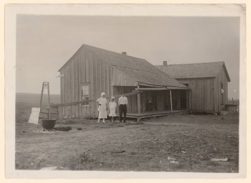
Actions:
Reference number:
PH1980:1138
Description:
Photograph taken while Lewis Wickes Hine was working for the National Child Labor Committee. Caption from NCLC caption card: "A dilapidated 'renters' home near West. The Tripp farm. Five in the family. Girl (apparently fifteen years old) is married. The farm contains a hundred and fifty acres now. A larger farm of eight hundred acres was cut up into this and three others - to rent".
PH1980:1138
Description:
Photograph taken while Lewis Wickes Hine was working for the National Child Labor Committee. Caption from NCLC caption card: "A dilapidated 'renters' home near West. The Tripp farm. Five in the family. Girl (apparently fifteen years old) is married. The farm contains a hundred and fifty acres now. A larger farm of eight hundred acres was cut up into this and three others - to rent".
People:
Date:
November 1913
November 1913
Title:
View of members of the Tripp family in front of the farmhouse they rent near West, Texas, United States
Actions:
PH1980:1138
Description:
Photograph taken while Lewis Wickes Hine was working for the National Child Labor Committee. Caption from NCLC caption card: "A dilapidated 'renters' home near West. The Tripp farm. Five in the family. Girl (apparently fifteen years old) is married. The farm contains a hundred and fifty acres now. A larger farm of eight hundred acres was cut up into this and three others - to rent".
View of members of the Tripp family in front of the farmhouse they rent near West, Texas, United States
Actions:
PH1980:1138
Description:
Photograph taken while Lewis Wickes Hine was working for the National Child Labor Committee. Caption from NCLC caption card: "A dilapidated 'renters' home near West. The Tripp farm. Five in the family. Girl (apparently fifteen years old) is married. The farm contains a hundred and fifty acres now. A larger farm of eight hundred acres was cut up into this and three others - to rent".
Form:
photographs
photographs
Date:
November 1913
November 1913
People:
Level of archival description:
Project
Project
Title:
House X
House X
Reference number:
AP143.S4.D20
Description:
File documents an unexecuted project for House X, designed for Mr. and Mrs. Arnold Aronoff for a 40-acre site on Lahser Road, Bloomfield Hills, Michigan. The ground floor consists of a kitchen, dining room, breakfast room, laundry room, two powder rooms and two garages. The second floor consists of a master suite with study, two bedrooms, bathroom, family and living rooms, bar, bathhouse and deck. The third floor consists of a solarium, terrace, bedroom and maid's room with bathroom. A swimming pool, tennis court and gatehouse are situated on the grounds. Thirteen schemes were developed for this project: A, A1, B, C, C1, C2, D, E, E1, E2, F, G, H. Only schemes G and H were developed into detailed floor plans. The drawings have been organized by drawing type, because of the subtle variations which characterize each scheme. Eisenman manipulates the four "els" (fragmentary forms - the three-sided portion of a hollow cube - that he introduced in House X to replace the cube, the preferred generating volume of his first five houses) in over 200 conceptual drawings (DR1994:0138:001-0219). There are numerous design development and complete sets of working drawings (design development drawings: DR1994:0138:239-541; working drawings: DR1994:0138:1182-1457). The project was extensively published, and the file includes a number of drawings and models created for exhibition and publication, including photographs of models (DR1994:0138:1481-1501), pieces of the "axonometric model" constructed after the project had been abandoned (DR1994:0138:1458-1476), and coloured paper cut-outs for collages (cut-outs, DR1994:0138:0929-0933 and DR1994:0138:1477-1480; collage: DR1994:0138:0928). The file also includes drawings and reprographic copies for the following projects: a residence for Mr. and Mrs. Aronoff,designed by Irving E. Palmquist, (DR1994:0138:1512-1521); Bernstein House, Mamaroneck, New York, designed by John Hejduk (DR1994:0138:1524-1531); Maison Domino by Le Corbusier (DR1994:0138:0944-0965); and land subdivision and houses for Arnold Aronoff, designed by Eisenman (DR1994:0138:0434-0441). Material in this file was produced between 1960 and 1977. File contains conceptual drawings, design development drawings, photographic materials, presentation drawings, presentation panels, publication drawings, record drawings, schematic drawings, a study model, textual records, and working drawings.
AP143.S4.D20
Description:
File documents an unexecuted project for House X, designed for Mr. and Mrs. Arnold Aronoff for a 40-acre site on Lahser Road, Bloomfield Hills, Michigan. The ground floor consists of a kitchen, dining room, breakfast room, laundry room, two powder rooms and two garages. The second floor consists of a master suite with study, two bedrooms, bathroom, family and living rooms, bar, bathhouse and deck. The third floor consists of a solarium, terrace, bedroom and maid's room with bathroom. A swimming pool, tennis court and gatehouse are situated on the grounds. Thirteen schemes were developed for this project: A, A1, B, C, C1, C2, D, E, E1, E2, F, G, H. Only schemes G and H were developed into detailed floor plans. The drawings have been organized by drawing type, because of the subtle variations which characterize each scheme. Eisenman manipulates the four "els" (fragmentary forms - the three-sided portion of a hollow cube - that he introduced in House X to replace the cube, the preferred generating volume of his first five houses) in over 200 conceptual drawings (DR1994:0138:001-0219). There are numerous design development and complete sets of working drawings (design development drawings: DR1994:0138:239-541; working drawings: DR1994:0138:1182-1457). The project was extensively published, and the file includes a number of drawings and models created for exhibition and publication, including photographs of models (DR1994:0138:1481-1501), pieces of the "axonometric model" constructed after the project had been abandoned (DR1994:0138:1458-1476), and coloured paper cut-outs for collages (cut-outs, DR1994:0138:0929-0933 and DR1994:0138:1477-1480; collage: DR1994:0138:0928). The file also includes drawings and reprographic copies for the following projects: a residence for Mr. and Mrs. Aronoff,designed by Irving E. Palmquist, (DR1994:0138:1512-1521); Bernstein House, Mamaroneck, New York, designed by John Hejduk (DR1994:0138:1524-1531); Maison Domino by Le Corbusier (DR1994:0138:0944-0965); and land subdivision and houses for Arnold Aronoff, designed by Eisenman (DR1994:0138:0434-0441). Material in this file was produced between 1960 and 1977. File contains conceptual drawings, design development drawings, photographic materials, presentation drawings, presentation panels, publication drawings, record drawings, schematic drawings, a study model, textual records, and working drawings.
People:
Date:
1960-1977
1960-1977
Title:
House X
Actions:
AP143.S4.D20
Description:
File documents an unexecuted project for House X, designed for Mr. and Mrs. Arnold Aronoff for a 40-acre site on Lahser Road, Bloomfield Hills, Michigan. The ground floor consists of a kitchen, dining room, breakfast room, laundry room, two powder rooms and two garages. The second floor consists of a master suite with study, two bedrooms, bathroom, family and living rooms, bar, bathhouse and deck. The third floor consists of a solarium, terrace, bedroom and maid's room with bathroom. A swimming pool, tennis court and gatehouse are situated on the grounds. Thirteen schemes were developed for this project: A, A1, B, C, C1, C2, D, E, E1, E2, F, G, H. Only schemes G and H were developed into detailed floor plans. The drawings have been organized by drawing type, because of the subtle variations which characterize each scheme. Eisenman manipulates the four "els" (fragmentary forms - the three-sided portion of a hollow cube - that he introduced in House X to replace the cube, the preferred generating volume of his first five houses) in over 200 conceptual drawings (DR1994:0138:001-0219). There are numerous design development and complete sets of working drawings (design development drawings: DR1994:0138:239-541; working drawings: DR1994:0138:1182-1457). The project was extensively published, and the file includes a number of drawings and models created for exhibition and publication, including photographs of models (DR1994:0138:1481-1501), pieces of the "axonometric model" constructed after the project had been abandoned (DR1994:0138:1458-1476), and coloured paper cut-outs for collages (cut-outs, DR1994:0138:0929-0933 and DR1994:0138:1477-1480; collage: DR1994:0138:0928). The file also includes drawings and reprographic copies for the following projects: a residence for Mr. and Mrs. Aronoff,designed by Irving E. Palmquist, (DR1994:0138:1512-1521); Bernstein House, Mamaroneck, New York, designed by John Hejduk (DR1994:0138:1524-1531); Maison Domino by Le Corbusier (DR1994:0138:0944-0965); and land subdivision and houses for Arnold Aronoff, designed by Eisenman (DR1994:0138:0434-0441). Material in this file was produced between 1960 and 1977. File contains conceptual drawings, design development drawings, photographic materials, presentation drawings, presentation panels, publication drawings, record drawings, schematic drawings, a study model, textual records, and working drawings.
House X
Actions:
AP143.S4.D20
Description:
File documents an unexecuted project for House X, designed for Mr. and Mrs. Arnold Aronoff for a 40-acre site on Lahser Road, Bloomfield Hills, Michigan. The ground floor consists of a kitchen, dining room, breakfast room, laundry room, two powder rooms and two garages. The second floor consists of a master suite with study, two bedrooms, bathroom, family and living rooms, bar, bathhouse and deck. The third floor consists of a solarium, terrace, bedroom and maid's room with bathroom. A swimming pool, tennis court and gatehouse are situated on the grounds. Thirteen schemes were developed for this project: A, A1, B, C, C1, C2, D, E, E1, E2, F, G, H. Only schemes G and H were developed into detailed floor plans. The drawings have been organized by drawing type, because of the subtle variations which characterize each scheme. Eisenman manipulates the four "els" (fragmentary forms - the three-sided portion of a hollow cube - that he introduced in House X to replace the cube, the preferred generating volume of his first five houses) in over 200 conceptual drawings (DR1994:0138:001-0219). There are numerous design development and complete sets of working drawings (design development drawings: DR1994:0138:239-541; working drawings: DR1994:0138:1182-1457). The project was extensively published, and the file includes a number of drawings and models created for exhibition and publication, including photographs of models (DR1994:0138:1481-1501), pieces of the "axonometric model" constructed after the project had been abandoned (DR1994:0138:1458-1476), and coloured paper cut-outs for collages (cut-outs, DR1994:0138:0929-0933 and DR1994:0138:1477-1480; collage: DR1994:0138:0928). The file also includes drawings and reprographic copies for the following projects: a residence for Mr. and Mrs. Aronoff,designed by Irving E. Palmquist, (DR1994:0138:1512-1521); Bernstein House, Mamaroneck, New York, designed by John Hejduk (DR1994:0138:1524-1531); Maison Domino by Le Corbusier (DR1994:0138:0944-0965); and land subdivision and houses for Arnold Aronoff, designed by Eisenman (DR1994:0138:0434-0441). Material in this file was produced between 1960 and 1977. File contains conceptual drawings, design development drawings, photographic materials, presentation drawings, presentation panels, publication drawings, record drawings, schematic drawings, a study model, textual records, and working drawings.
Level of archival description:
File 20
File 20
Date:
1960-1977
1960-1977
People:


