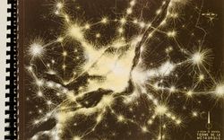
photographies
Quantité:
475 File
ARCH274402
ca. 1973
photographies
Quantité:
475 File
ca. 1973
Where We Grow Older
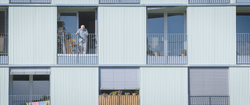
Le documentaire Where We Grow Older (CCA, 2023, 30 min) examine la manière dont le vieillissement croissant de la population remodèle les constructions architecturales et sociales et sinterroge sur le rôle de lurbanisme et de la politique face à ces défis. Le film étudie deux modèles de reconception des soins et du logement à la lumière de la prolongation de la vie : le(...)
Where We Grow Older, CCA film, Festival du film de Porto, festival du film d'Arquiteturas, where life happens, what it takes to make a home, when we live alone, INSTITUTO, Batalha Centro de Cinema
juin 2023
Where We Grow Older
Actions:
Description:
Le documentaire Where We Grow Older (CCA, 2023, 30 min) examine la manière dont le vieillissement croissant de la population remodèle les constructions architecturales et sociales et sinterroge sur le rôle de lurbanisme et de la politique face à ces défis. Le film étudie deux modèles de reconception des soins et du logement à la lumière de la prolongation de la vie : le(...)
Projet
AP027.S1.D14
Description:
This project series documents a master plan for the proposed development of 6000 acres of land in the northern half of Mississauga a suburb of Toronto, Ontario. The aim was for the new development was to absorb some of the population from the metropolitan area and form part of an urban belt extending from Oshawa to Stoney Creek. The design integrates residential, commercial, and industrial zones for a population of more than 100,000 people. The project series includes background studies and designs for housing units, shopping centre, research centre, and the industrial area.
1960-1962
Meadowvale, Mississauga, Ontario, Canada (1960-1962)
Actions:
AP027.S1.D14
Description:
This project series documents a master plan for the proposed development of 6000 acres of land in the northern half of Mississauga a suburb of Toronto, Ontario. The aim was for the new development was to absorb some of the population from the metropolitan area and form part of an urban belt extending from Oshawa to Stoney Creek. The design integrates residential, commercial, and industrial zones for a population of more than 100,000 people. The project series includes background studies and designs for housing units, shopping centre, research centre, and the industrial area.
File 14
1960-1962
dessins, documents textuels
Newtown, Newfoundland 1966
ARCH253555
Description:
correspondence, maps, population growth
1966
Newtown, Newfoundland 1966
Actions:
ARCH253555
Description:
correspondence, maps, population growth
dessins, documents textuels
1966
Projet
AP027.S1.D47
Description:
Proposed simulation model concerned with urban renewal in North Philadelphia, an area which houses a resident population in excess of 300,000 people. The proposed analysis would examine the social, economic and physical systems affected by renewal.
urbanisme
1968
Model City, Philadelphia
Actions:
AP027.S1.D47
Description:
Proposed simulation model concerned with urban renewal in North Philadelphia, an area which houses a resident population in excess of 300,000 people. The proposed analysis would examine the social, economic and physical systems affected by renewal.
File 47
1968
urbanisme
Projet
AP027.S1.D50
Description:
A comprehensive study of education in the province of Prince Edward Island. A basic assessment of resources and their development was undertaken for a joint federal-provincial development program. The future location of population and recommendations regarding change in administrative structures, programming, site selection, and enrolment is analyzed.
urbanisme
1969
Educational Programs, Prince Edward Island
Actions:
AP027.S1.D50
Description:
A comprehensive study of education in the province of Prince Edward Island. A basic assessment of resources and their development was undertaken for a joint federal-provincial development program. The future location of population and recommendations regarding change in administrative structures, programming, site selection, and enrolment is analyzed.
File 50
1969
urbanisme
articles
C’était le futur
dessins
ARCH260630
Description:
design development drawings - schemes and site plans, transit studies, population trend graphs, sections through Granville Street
1974
Design development drawings - schemes and site plans
Actions:
ARCH260630
Description:
design development drawings - schemes and site plans, transit studies, population trend graphs, sections through Granville Street
dessins
1974
dessins
Quantité:
11 File
ARCH262063
Description:
Street level plan, elevations, perspective of corner, floor plans, pie charts studying space, department interrelations, and population.
1972
Street level plan, elevations, perspective of corner
Actions:
ARCH262063
Description:
Street level plan, elevations, perspective of corner, floor plans, pie charts studying space, department interrelations, and population.
dessins
Quantité:
11 File
1972
dessins
Quantité:
20 design development drawing(s)
DR2004:0232
Description:
elevations, axonometric diagrams, elevations, showing eye levels, population distribution table, diagrams of noise levels, side elevations, and axonometric details
Elevations, axonometric diagrams, elevations, showing eye levels
Actions:
DR2004:0232
Description:
elevations, axonometric diagrams, elevations, showing eye levels, population distribution table, diagrams of noise levels, side elevations, and axonometric details
dessins
Quantité:
20 design development drawing(s)

