35831 Résultats
Classification:
photographies
photographies
Actions:
Numéro de référence:
PH1997:0060
Description:
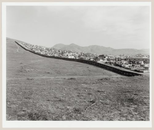
The series "Running Fence 1997" focuses "on the first 14 miles of the border fence that separates the United States and Mexico, beginning at the Pacific Ocean and ending in the Otay Mountains.... [It] analyzes the "idea" of the border and explores its iconography, the border being a subject that is of extreme importance to the public as the world proceeds towards greater globalization. [Geoffrey] James has written of the project: "[The border fence] was built by the US Army Corps of Engineers in 1994, out of recycled metal landing strip - the most visible symbol of what is known as Operation Gatekeeper. Because the steel sheets are placed in the ground so that their ridges run horizontally, a man can hop over the fence with ease; and no Mexican child ever seems to be impeded from retrieving a soccer ball from US territory. The real barrier to illegal immigration from Mexico into the USA is less visible: hundreds of buried sensors linked to a central computer, nightscopes, helicopters and Border Patrol Agents in white Broncos."" (Evans).
PH1997:0060
Description:
The series "Running Fence 1997" focuses "on the first 14 miles of the border fence that separates the United States and Mexico, beginning at the Pacific Ocean and ending in the Otay Mountains.... [It] analyzes the "idea" of the border and explores its iconography, the border being a subject that is of extreme importance to the public as the world proceeds towards greater globalization. [Geoffrey] James has written of the project: "[The border fence] was built by the US Army Corps of Engineers in 1994, out of recycled metal landing strip - the most visible symbol of what is known as Operation Gatekeeper. Because the steel sheets are placed in the ground so that their ridges run horizontally, a man can hop over the fence with ease; and no Mexican child ever seems to be impeded from retrieving a soccer ball from US territory. The real barrier to illegal immigration from Mexico into the USA is less visible: hundreds of buried sensors linked to a central computer, nightscopes, helicopters and Border Patrol Agents in white Broncos."" (Evans).
Personnes et institutions:
Sujet:
architecture, ingénierie, topographique
architecture, ingénierie, topographique
Date:
1997
1997
Titre:
View of Otay Mesa, Mexico from San Diego County, California showing the United States-Mexico border fence, from the series "Running Fence"
Actions:
PH1997:0060
Description:
The series "Running Fence 1997" focuses "on the first 14 miles of the border fence that separates the United States and Mexico, beginning at the Pacific Ocean and ending in the Otay Mountains.... [It] analyzes the "idea" of the border and explores its iconography, the border being a subject that is of extreme importance to the public as the world proceeds towards greater globalization. [Geoffrey] James has written of the project: "[The border fence] was built by the US Army Corps of Engineers in 1994, out of recycled metal landing strip - the most visible symbol of what is known as Operation Gatekeeper. Because the steel sheets are placed in the ground so that their ridges run horizontally, a man can hop over the fence with ease; and no Mexican child ever seems to be impeded from retrieving a soccer ball from US territory. The real barrier to illegal immigration from Mexico into the USA is less visible: hundreds of buried sensors linked to a central computer, nightscopes, helicopters and Border Patrol Agents in white Broncos."" (Evans).
Classification:
photographies
photographies
Date:
1997
1997
Personnes et institutions:
Sujet:
architecture, ingénierie, topographique
architecture, ingénierie, topographique
Classification:
photographies
photographies
Actions:
Numéro de référence:
PH1997:0061
Description:
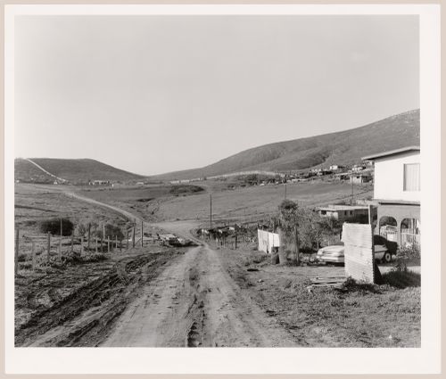
- The series "Running Fence 1997" focuses "on the first 14 miles of the border fence that separates the United States and Mexico, beginning at the Pacific Ocean and ending in the Otay Mountains.... [It] analyzes the "idea" of the border and explores its iconography, the border being a subject that is of extreme importance to the public as the world proceeds towards greater globalization. [Geoffrey] James has written of the project: "[The border fence] was built by the US Army Corps of Engineers in 1994, out of recycled metal landing strip - the most visible symbol of what is known as Operation Gatekeeper. Because the steel sheets are placed in the ground so that their ridges run horizontally, a man can hop over the fence with ease; and no Mexican child ever seems to be impeded from retrieving a soccer ball from US territory. The real barrier to illegal immigration from Mexico into the USA is less visible: hundreds of buried sensors linked to a central computer, nightscopes, helicopters and Border Patrol Agents in white Broncos."" (Evans).
PH1997:0061
Description:
- The series "Running Fence 1997" focuses "on the first 14 miles of the border fence that separates the United States and Mexico, beginning at the Pacific Ocean and ending in the Otay Mountains.... [It] analyzes the "idea" of the border and explores its iconography, the border being a subject that is of extreme importance to the public as the world proceeds towards greater globalization. [Geoffrey] James has written of the project: "[The border fence] was built by the US Army Corps of Engineers in 1994, out of recycled metal landing strip - the most visible symbol of what is known as Operation Gatekeeper. Because the steel sheets are placed in the ground so that their ridges run horizontally, a man can hop over the fence with ease; and no Mexican child ever seems to be impeded from retrieving a soccer ball from US territory. The real barrier to illegal immigration from Mexico into the USA is less visible: hundreds of buried sensors linked to a central computer, nightscopes, helicopters and Border Patrol Agents in white Broncos."" (Evans).
Personnes et institutions:
Sujet:
architecture, ingénierie, topographique
architecture, ingénierie, topographique
Date:
1997
1997
Titre:
View of roads and houses with a partial view of the United States-Mexico border fence, Otay Mesa, San Diego County, California, United States, and Tijuana, Baja California, Mexico
Actions:
PH1997:0061
Description:
- The series "Running Fence 1997" focuses "on the first 14 miles of the border fence that separates the United States and Mexico, beginning at the Pacific Ocean and ending in the Otay Mountains.... [It] analyzes the "idea" of the border and explores its iconography, the border being a subject that is of extreme importance to the public as the world proceeds towards greater globalization. [Geoffrey] James has written of the project: "[The border fence] was built by the US Army Corps of Engineers in 1994, out of recycled metal landing strip - the most visible symbol of what is known as Operation Gatekeeper. Because the steel sheets are placed in the ground so that their ridges run horizontally, a man can hop over the fence with ease; and no Mexican child ever seems to be impeded from retrieving a soccer ball from US territory. The real barrier to illegal immigration from Mexico into the USA is less visible: hundreds of buried sensors linked to a central computer, nightscopes, helicopters and Border Patrol Agents in white Broncos."" (Evans).
Classification:
photographies
photographies
Date:
1997
1997
Personnes et institutions:
Sujet:
architecture, ingénierie, topographique
architecture, ingénierie, topographique
Classification:
photographies
photographies
Actions:
Numéro de référence:
PH1997:0062
Description:
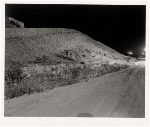
- The series "Running Fence 1997" focuses "on the first 14 miles of the border fence that separates the United States and Mexico, beginning at the Pacific Ocean and ending in the Otay Mountains.... [It] analyzes the "idea" of the border and explores its iconography, the border being a subject that is of extreme importance to the public as the world proceeds towards greater globalization. [Geoffrey] James has written of the project: "[The border fence] was built by the US Army Corps of Engineers in 1994, out of recycled metal landing strip - the most visible symbol of what is known as Operation Gatekeeper. Because the steel sheets are placed in the ground so that their ridges run horizontally, a man can hop over the fence with ease; and no Mexican child ever seems to be impeded from retrieving a soccer ball from US territory. The real barrier to illegal immigration from Mexico into the USA is less visible: hundreds of buried sensors linked to a central computer, nightscopes, helicopters and Border Patrol Agents in white Broncos."" (Evans).
PH1997:0062
Description:
- The series "Running Fence 1997" focuses "on the first 14 miles of the border fence that separates the United States and Mexico, beginning at the Pacific Ocean and ending in the Otay Mountains.... [It] analyzes the "idea" of the border and explores its iconography, the border being a subject that is of extreme importance to the public as the world proceeds towards greater globalization. [Geoffrey] James has written of the project: "[The border fence] was built by the US Army Corps of Engineers in 1994, out of recycled metal landing strip - the most visible symbol of what is known as Operation Gatekeeper. Because the steel sheets are placed in the ground so that their ridges run horizontally, a man can hop over the fence with ease; and no Mexican child ever seems to be impeded from retrieving a soccer ball from US territory. The real barrier to illegal immigration from Mexico into the USA is less visible: hundreds of buried sensors linked to a central computer, nightscopes, helicopters and Border Patrol Agents in white Broncos."" (Evans).
Personnes et institutions:
Sujet:
architecture, ingénierie
architecture, ingénierie
Date:
1997
1997
Titre:
Partial night view of the United States-Mexico border fence from the United States side, San Diego County, California, United States, and Tijuana, Baja California, Mexico
Actions:
PH1997:0062
Description:
- The series "Running Fence 1997" focuses "on the first 14 miles of the border fence that separates the United States and Mexico, beginning at the Pacific Ocean and ending in the Otay Mountains.... [It] analyzes the "idea" of the border and explores its iconography, the border being a subject that is of extreme importance to the public as the world proceeds towards greater globalization. [Geoffrey] James has written of the project: "[The border fence] was built by the US Army Corps of Engineers in 1994, out of recycled metal landing strip - the most visible symbol of what is known as Operation Gatekeeper. Because the steel sheets are placed in the ground so that their ridges run horizontally, a man can hop over the fence with ease; and no Mexican child ever seems to be impeded from retrieving a soccer ball from US territory. The real barrier to illegal immigration from Mexico into the USA is less visible: hundreds of buried sensors linked to a central computer, nightscopes, helicopters and Border Patrol Agents in white Broncos."" (Evans).
Classification:
photographies
photographies
Date:
1997
1997
Personnes et institutions:
Sujet:
architecture, ingénierie
architecture, ingénierie
Classification:
photographies
photographies
Actions:
Numéro de référence:
PH1997:0063
Description:
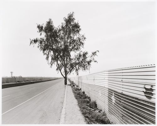
- The series "Running Fence 1997" focuses "on the first 14 miles of the border fence that separates the United States and Mexico, beginning at the Pacific Ocean and ending in the Otay Mountains.... [It] analyzes the "idea" of the border and explores its iconography, the border being a subject that is of extreme importance to the public as the world proceeds towards greater globalization. [Geoffrey] James has written of the project: "[The border fence] was built by the US Army Corps of Engineers in 1994, out of recycled metal landing strip - the most visible symbol of what is known as Operation Gatekeeper. Because the steel sheets are placed in the ground so that their ridges run horizontally, a man can hop over the fence with ease; and no Mexican child ever seems to be impeded from retrieving a soccer ball from US territory. The real barrier to illegal immigration from Mexico into the USA is less visible: hundreds of buried sensors linked to a central computer, nightscopes, helicopters and Border Patrol Agents in white Broncos."" (Evans).
PH1997:0063
Description:
- The series "Running Fence 1997" focuses "on the first 14 miles of the border fence that separates the United States and Mexico, beginning at the Pacific Ocean and ending in the Otay Mountains.... [It] analyzes the "idea" of the border and explores its iconography, the border being a subject that is of extreme importance to the public as the world proceeds towards greater globalization. [Geoffrey] James has written of the project: "[The border fence] was built by the US Army Corps of Engineers in 1994, out of recycled metal landing strip - the most visible symbol of what is known as Operation Gatekeeper. Because the steel sheets are placed in the ground so that their ridges run horizontally, a man can hop over the fence with ease; and no Mexican child ever seems to be impeded from retrieving a soccer ball from US territory. The real barrier to illegal immigration from Mexico into the USA is less visible: hundreds of buried sensors linked to a central computer, nightscopes, helicopters and Border Patrol Agents in white Broncos."" (Evans).
Personnes et institutions:
Sujet:
architecture, ingénierie
architecture, ingénierie
Date:
1997
1997
Titre:
View along a highway leading to the airport in Tijuana, Baja California, Mexico, showing a partial view of the United States-Mexico border fence
Actions:
PH1997:0063
Description:
- The series "Running Fence 1997" focuses "on the first 14 miles of the border fence that separates the United States and Mexico, beginning at the Pacific Ocean and ending in the Otay Mountains.... [It] analyzes the "idea" of the border and explores its iconography, the border being a subject that is of extreme importance to the public as the world proceeds towards greater globalization. [Geoffrey] James has written of the project: "[The border fence] was built by the US Army Corps of Engineers in 1994, out of recycled metal landing strip - the most visible symbol of what is known as Operation Gatekeeper. Because the steel sheets are placed in the ground so that their ridges run horizontally, a man can hop over the fence with ease; and no Mexican child ever seems to be impeded from retrieving a soccer ball from US territory. The real barrier to illegal immigration from Mexico into the USA is less visible: hundreds of buried sensors linked to a central computer, nightscopes, helicopters and Border Patrol Agents in white Broncos."" (Evans).
Classification:
photographies
photographies
Date:
1997
1997
Personnes et institutions:
Sujet:
architecture, ingénierie
architecture, ingénierie
Classification:
archives
Niveau de description archivistique:
Fonds
archives
Niveau de description archivistique:
Fonds
Titre:
Fonds Peter Carter
Fonds Peter Carter
Numéro de référence:
AP047
Résumé:
The Peter Carter fonds, 1943-1996, documents the professional career of architect Peter Carter. The largest portion of the archive corresponds to projects Carter completed as principal of the office, Peter Carter Architect (1974-96). Materials in this fonds consist of 7263 drawings (including reprographic copies), 2007 photographic materials, approximately 65 panels, 3 l.m. of textual records, 26 models, 1 enclosing unit, 1 carpet sample, 1 graphic design layout for stationery letterhead, 1 brown oak sample, 1 window sample, 1 sign, 1 carioca stone, 1 travertine block and 1 grey carpet tile.
Personnes et institutions:
Date:
1943-1996
1943-1996
Titre:
Fonds Peter Carter
Actions:
AP047
Résumé:
The Peter Carter fonds, 1943-1996, documents the professional career of architect Peter Carter. The largest portion of the archive corresponds to projects Carter completed as principal of the office, Peter Carter Architect (1974-96). Materials in this fonds consist of 7263 drawings (including reprographic copies), 2007 photographic materials, approximately 65 panels, 3 l.m. of textual records, 26 models, 1 enclosing unit, 1 carpet sample, 1 graphic design layout for stationery letterhead, 1 brown oak sample, 1 window sample, 1 sign, 1 carioca stone, 1 travertine block and 1 grey carpet tile.
Classification:
archives
Niveau de description archivistique:
Fonds
archives
Niveau de description archivistique:
Fonds
Date:
1943-1996
1943-1996
Personnes et institutions:
Niveau de description archivistique:
Projet
Projet
Numéro de référence:
AP018.S1.1972.PR18
Description:
This project series documents the design and construction of a library and an addition to city hall in Fredericton, New Brunswick from 1972-1975. The office identified the project number as 7226. This project consisted of two distinct parts; a public library constructed at the corners of Campbell and Carleton Streets, and an addition to city hall whose original building was constructed at the corners of Queen and York Streets around 1875. These two buildings were located two blocks from one another, but a master plan for the project shows that the separating streets would be removed in favour of a pedestrian friendly landscape. Both buildings were located next to the St. John River. For this project, Parkin Architects Planners partnered with architectural firm Graham Napier Associates to form the joint venture referred to as Graham Parkin Architects Engineers Planners. The brick-clad addition to city hall nearly doubled the square footage of the ground and first floors. The original city hall was four levels and the addition was two, with a mechanical penthouse on top. The new areas included departmental offices such as planning, engineering and sewage, a drafting room, conference room, and reception, among others. The library consisted of a two-storey, brick-clad building that was approximately 24,000 square feet in size with a 16 car parking lot. The ground floor included reception and exhibit areas, stacks, administration offices, bookmobiles, and staff lockers, while the second level had stacks and reading areas, audiovisual areas and a staff work room and break room. The library also had a mechanical penthouse on top. The project is recorded through drawings, including mounted presentation boards, photographic materials and textual records dating from 1972-1978. The drawings consist of original sketches, plans, sections, elevations and details of both city hall and the library, and some drawings used for construction. There are also drawings of the original city hall, first drafted around 1875. The photographs show existing buildings and the construction progress of the project. The textual records consist of correspondence, conference reports, interoffice letters, specifications, consultancy documentation, a soil investigation, research and drawing transmittal records. File AP018.S1.1972.PR18.020 contains an index to the textual materials, which was created by the office.
Personnes et institutions:
Date:
circa 1972-1978
circa 1972-1978
Titre:
City Hall and Library Facilities, Fredericton, New Brunswick (1972-1975)
Actions:
AP018.S1.1972.PR18
Description:
This project series documents the design and construction of a library and an addition to city hall in Fredericton, New Brunswick from 1972-1975. The office identified the project number as 7226. This project consisted of two distinct parts; a public library constructed at the corners of Campbell and Carleton Streets, and an addition to city hall whose original building was constructed at the corners of Queen and York Streets around 1875. These two buildings were located two blocks from one another, but a master plan for the project shows that the separating streets would be removed in favour of a pedestrian friendly landscape. Both buildings were located next to the St. John River. For this project, Parkin Architects Planners partnered with architectural firm Graham Napier Associates to form the joint venture referred to as Graham Parkin Architects Engineers Planners. The brick-clad addition to city hall nearly doubled the square footage of the ground and first floors. The original city hall was four levels and the addition was two, with a mechanical penthouse on top. The new areas included departmental offices such as planning, engineering and sewage, a drafting room, conference room, and reception, among others. The library consisted of a two-storey, brick-clad building that was approximately 24,000 square feet in size with a 16 car parking lot. The ground floor included reception and exhibit areas, stacks, administration offices, bookmobiles, and staff lockers, while the second level had stacks and reading areas, audiovisual areas and a staff work room and break room. The library also had a mechanical penthouse on top. The project is recorded through drawings, including mounted presentation boards, photographic materials and textual records dating from 1972-1978. The drawings consist of original sketches, plans, sections, elevations and details of both city hall and the library, and some drawings used for construction. There are also drawings of the original city hall, first drafted around 1875. The photographs show existing buildings and the construction progress of the project. The textual records consist of correspondence, conference reports, interoffice letters, specifications, consultancy documentation, a soil investigation, research and drawing transmittal records. File AP018.S1.1972.PR18.020 contains an index to the textual materials, which was created by the office.
Niveau de description archivistique:
Project
Project
Date:
circa 1972-1978
circa 1972-1978
Personnes et institutions:
Classification:
documents textuels
documents textuels
Numéro de référence:
ARCH267394
Description:
This group consists of minutes of meetings, notes, schedules, correspondence and related documents concerning the Palais des Congrès de Montréal. There are also a partnership agreement between the architects of the Palais des Congrès, an organization chart and a professional services contract between the architects and the Ministère des Travaux publics et de l'Approvisionnement du Québec.
Personnes et institutions:
Date:
1978-1982
1978-1982
Titre:
Centre de Congrès / Contrat avec MTPA / Convention de société
Actions:
ARCH267394
Description:
This group consists of minutes of meetings, notes, schedules, correspondence and related documents concerning the Palais des Congrès de Montréal. There are also a partnership agreement between the architects of the Palais des Congrès, an organization chart and a professional services contract between the architects and the Ministère des Travaux publics et de l'Approvisionnement du Québec.
Classification:
documents textuels
documents textuels
Date:
1978-1982
1978-1982
Personnes et institutions:
Classification:
événements
événements

Actions:
Description:
La veille du jour de l’An 1987, 4000 tonnes de cendres toxiques sont livrées aux habitants des Gonaïves, une ville portuaire démunie sur la côte occidentale d’Haïti. Dans un contexte politique instable, des fonctionnaires haïtiens ont autorisé l’importation de déchets toxiques des États-Unis, catégorisés comme des «fertilisants». Dans ce cas, la cendre provient de(...)
La veille du jour de l’An 1987, 4000 tonnes de cendres toxiques sont livrées aux habitants des Gonaïves, une ville portuaire démunie sur la côte occidentale d’Haïti. Dans un contexte politique instable, des fonctionnaires haïtiens ont autorisé l’importation de déchets toxiques des États-Unis, catégorisés comme des «fertilisants». Dans ce cas, la cendre provient de(...)
Date:
16 mars 2017
16 mars 2017
Titre:
C’est toxique ici, mais pas là-bas
Actions:
Description:
La veille du jour de l’An 1987, 4000 tonnes de cendres toxiques sont livrées aux habitants des Gonaïves, une ville portuaire démunie sur la côte occidentale d’Haïti. Dans un contexte politique instable, des fonctionnaires haïtiens ont autorisé l’importation de déchets toxiques des États-Unis, catégorisés comme des «fertilisants». Dans ce cas, la cendre provient de(...)
Classification:
événements
événements
Date:
16 mars 2017
16 mars 2017
Classification:
événements
événements

Titre:
Freegans
Freegans
Actions:
Description:
Emily Rauhala, journaliste vivant à Hong Kong, parle de la philosophie anticonsumériste des « freegans » -ou « fouilleurs de poubelles » – qui dénichent des quantités astronomiques de produits alimentaires encore comestibles et d’autres produits dans les bennes à ordures de nos villes, pour les redistribuer aux personnes dans le besoin, ou pour leur consommation(...)
Emily Rauhala, journaliste vivant à Hong Kong, parle de la philosophie anticonsumériste des « freegans » -ou « fouilleurs de poubelles » – qui dénichent des quantités astronomiques de produits alimentaires encore comestibles et d’autres produits dans les bennes à ordures de nos villes, pour les redistribuer aux personnes dans le besoin, ou pour leur consommation(...)
Localisation:
Théâtre Paul-Desmarais
Théâtre Paul-Desmarais
Date:
8 janvier 2009
8 janvier 2009
Titre:
Freegans
Actions:
Description:
Emily Rauhala, journaliste vivant à Hong Kong, parle de la philosophie anticonsumériste des « freegans » -ou « fouilleurs de poubelles » – qui dénichent des quantités astronomiques de produits alimentaires encore comestibles et d’autres produits dans les bennes à ordures de nos villes, pour les redistribuer aux personnes dans le besoin, ou pour leur consommation(...)
Classification:
événements
événements
Date:
8 janvier 2009
8 janvier 2009
Localisation:
Théâtre Paul-Desmarais
Théâtre Paul-Desmarais
Classification:
événements
événements
Titre:
Diversité urbaine
Diversité urbaine
Actions:
Description:
Deux représentants du collectif français Coloco, l’architecte Nicolas Bonnenfant et le paysagiste Miguel Georgieff, présentent leur projet « Habiter des squelettes » qui consiste à repérer et à reconvertir des structures abandonnées, véritables « squelettes urbains ». Leur projet redéfinit la notion d’auto-construction et y accole celle de gestion de la durée de vie des(...)
Deux représentants du collectif français Coloco, l’architecte Nicolas Bonnenfant et le paysagiste Miguel Georgieff, présentent leur projet « Habiter des squelettes » qui consiste à repérer et à reconvertir des structures abandonnées, véritables « squelettes urbains ». Leur projet redéfinit la notion d’auto-construction et y accole celle de gestion de la durée de vie des(...)
Localisation:
Théâtre Paul-Desmarais
Théâtre Paul-Desmarais
Date:
22 janvier 2009
22 janvier 2009
Titre:
Diversité urbaine
Actions:
Description:
Deux représentants du collectif français Coloco, l’architecte Nicolas Bonnenfant et le paysagiste Miguel Georgieff, présentent leur projet « Habiter des squelettes » qui consiste à repérer et à reconvertir des structures abandonnées, véritables « squelettes urbains ». Leur projet redéfinit la notion d’auto-construction et y accole celle de gestion de la durée de vie des(...)
Classification:
événements
événements
Date:
22 janvier 2009
22 janvier 2009
Localisation:
Théâtre Paul-Desmarais
Théâtre Paul-Desmarais