9765 Résultats
Niveau de description archivistique:
Projet
Projet
Numéro de référence:
AP075.S1.1979.PR05
Description:
Project series documents Cornelia Hahn Oberlander's landscape project for the Discovery Parks' site on the Simon Fraser University campus, in Burnaby, British Columbia. Created in 1979, Discovery Parks is an organization with the mission to accomodate scientific and technological research activities by building and renting research installations. Initially founded by the provincial government, Discovery Parks became self-governning and independant in 1990. Oberlander worked on this project from 1979-1984 with Russell Vandiver Architects. The project consisted in creating three research building north of University Drive, in the Naheeto Park, with landscaped recreational areas between each buildings. The project was later reduce to one research building located at the corner of Nelson Way and University Drive, on the far east end of the initial site. Oberlander's landscape design consisted in trees planting along the street, the parking lot and the driveway, and creating a recreational area for staff and students. The project series contains textual records, including research, Oberlander's concept notes, project proposals, correspondence with architect and clients, specifications, and financial documents. The project series also comprises photographs and working drawings, such as proposed sites plans, site plans, grading plans, planting plans and landscape plans.
Personnes et institutions:
Date:
1971-1989
1971-1989
Titre:
Discovery Parks, Simon Fraser University Site, Burnaby, British Columbia (1979-1984)
Actions:
AP075.S1.1979.PR05
Description:
Project series documents Cornelia Hahn Oberlander's landscape project for the Discovery Parks' site on the Simon Fraser University campus, in Burnaby, British Columbia. Created in 1979, Discovery Parks is an organization with the mission to accomodate scientific and technological research activities by building and renting research installations. Initially founded by the provincial government, Discovery Parks became self-governning and independant in 1990. Oberlander worked on this project from 1979-1984 with Russell Vandiver Architects. The project consisted in creating three research building north of University Drive, in the Naheeto Park, with landscaped recreational areas between each buildings. The project was later reduce to one research building located at the corner of Nelson Way and University Drive, on the far east end of the initial site. Oberlander's landscape design consisted in trees planting along the street, the parking lot and the driveway, and creating a recreational area for staff and students. The project series contains textual records, including research, Oberlander's concept notes, project proposals, correspondence with architect and clients, specifications, and financial documents. The project series also comprises photographs and working drawings, such as proposed sites plans, site plans, grading plans, planting plans and landscape plans.
Niveau de description archivistique:
Project
Project
Date:
1971-1989
1971-1989
Personnes et institutions:
Classification:
documents textuels
documents textuels
Actions:
Numéro de référence:
DR1974:0002:036:008:001-004
Description:
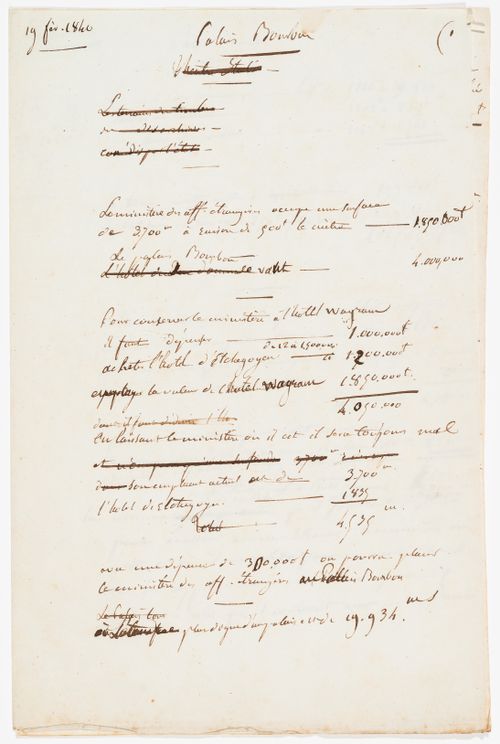
Manuscript DR1974:0002:036:008:001-004 documents various proposals for conserving the Ministère des Affaires Étrangères in its present location with some alterations, and for transferring it to the site of Palais Bourbon. A site plan for the Théâtre Royal Italien dated February 1840 shows the proposed opera house and surrounding infrastructure (DR1974:0002:036:009).
DR1974:0002:036:008:001-004
Description:
Manuscript DR1974:0002:036:008:001-004 documents various proposals for conserving the Ministère des Affaires Étrangères in its present location with some alterations, and for transferring it to the site of Palais Bourbon. A site plan for the Théâtre Royal Italien dated February 1840 shows the proposed opera house and surrounding infrastructure (DR1974:0002:036:009).
Personnes et institutions:
Sujet:
architecture
architecture
Date:
19 February 1840
19 February 1840
Titre:
Cost estimates for a project for an opera house for the Théâtre Royal Italien involving the transfer of the Ministère des Affaires Étrangères from Hôtel Wagram to Palais Bourbon
Actions:
DR1974:0002:036:008:001-004
Description:
Manuscript DR1974:0002:036:008:001-004 documents various proposals for conserving the Ministère des Affaires Étrangères in its present location with some alterations, and for transferring it to the site of Palais Bourbon. A site plan for the Théâtre Royal Italien dated February 1840 shows the proposed opera house and surrounding infrastructure (DR1974:0002:036:009).
Classification:
documents textuels
documents textuels
Date:
19 February 1840
19 February 1840
Personnes et institutions:
Sujet:
architecture
architecture
Classification:
photographies
photographies
Numéro de référence:
ARCH256427
Description:
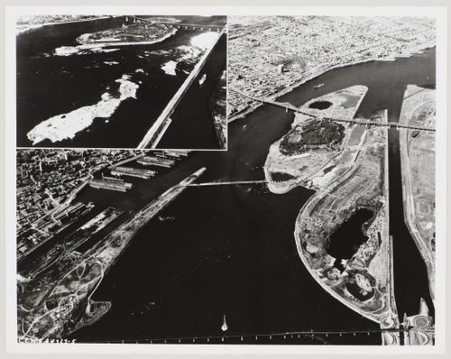
"The site of Expo, then and now. The inset shows Ile Sainte-Helene as of July 23, 1963, just before work began on enlarging the site. The main picture shows the Exhibition grounds today. / On voit ci-dessus le terrain de l'Exposition universelle et internationale de Montréal avant le début des travaux d'agrandissement, le 23 juillet 1963 en haut à gauche. Dans le reste de la photo, on voit sa configuration telle qu'elle est aujourd'hui."--Description.
ARCH256427
Description:
"The site of Expo, then and now. The inset shows Ile Sainte-Helene as of July 23, 1963, just before work began on enlarging the site. The main picture shows the Exhibition grounds today. / On voit ci-dessus le terrain de l'Exposition universelle et internationale de Montréal avant le début des travaux d'agrandissement, le 23 juillet 1963 en haut à gauche. Dans le reste de la photo, on voit sa configuration telle qu'elle est aujourd'hui."--Description.
Personnes et institutions:
Date:
1963-1965
1963-1965
Titre:
Aerial views of the Île Sainte-Hélène and Île Notre-Dame sites prior and after their enlargement, Expo 67, Montréal, Québec
Actions:
ARCH256427
Description:
"The site of Expo, then and now. The inset shows Ile Sainte-Helene as of July 23, 1963, just before work began on enlarging the site. The main picture shows the Exhibition grounds today. / On voit ci-dessus le terrain de l'Exposition universelle et internationale de Montréal avant le début des travaux d'agrandissement, le 23 juillet 1963 en haut à gauche. Dans le reste de la photo, on voit sa configuration telle qu'elle est aujourd'hui."--Description.
Classification:
photographies
photographies
Date:
1963-1965
1963-1965
Personnes et institutions:
Classification:
dessins, documents textuels, photographies
dessins, documents textuels, photographies
Numéro de référence:
DR2004:0260
Description:
clippings, report on Zagreb, research notes, calculations and sketches, publications, reports on traffic noise, brochures, housing committee report, price list, photographs, negatives, Lettraset sheet, photograph of model, housing research notes, statistics, and calculations, photographs of Tilbury site, negatives of site, consultant's calculations, sketches, graphs, promotional material, and conference presentation paper
Personnes et institutions:
Titre:
Clippings, report on Zagreb, research notes, calculations and sketches
Actions:
DR2004:0260
Description:
clippings, report on Zagreb, research notes, calculations and sketches, publications, reports on traffic noise, brochures, housing committee report, price list, photographs, negatives, Lettraset sheet, photograph of model, housing research notes, statistics, and calculations, photographs of Tilbury site, negatives of site, consultant's calculations, sketches, graphs, promotional material, and conference presentation paper
Classification:
dessins, documents textuels, photographies
dessins, documents textuels, photographies
Personnes et institutions:
Classification:
dessins
dessins
Numéro de référence:
DR2004:0597
Description:
site plans, maps, sketches, plans, axonometrics, sections, elevations, details, reference drawings, conceptual drawings, views of site, schematics, perspectives, drawings labelled with both the Strate and Newlink projects, clippings, brochure, schedule diagram, memorandum labelled with the Newlink and Sidings projects, view of model, view of escalators, and proposal document
Personnes et institutions:
Titre:
Site plans, maps, sketches, plans, axonometrics, sections
Actions:
DR2004:0597
Description:
site plans, maps, sketches, plans, axonometrics, sections, elevations, details, reference drawings, conceptual drawings, views of site, schematics, perspectives, drawings labelled with both the Strate and Newlink projects, clippings, brochure, schedule diagram, memorandum labelled with the Newlink and Sidings projects, view of model, view of escalators, and proposal document
Classification:
dessins
dessins
Personnes et institutions:
Classification:
documents textuels
documents textuels
Numéro de référence:
ARCH257191
Description:
correspondence, memos, cotst estimates, furniture information, brochures, sketches, site information, planning and schedule, agreements/contracts, clippings, b/w photographs and negatives of the site and harbour, various studies and proposals including Inner Harbour Renewal (1971), Victoria Inner Harbour Study (Arthur Erickson Architects, 1973), hotel interior design proposal (1977)
Personnes et institutions:
Date:
1978-1983
1978-1983
Titre:
Correspondence, memos, cotst estimates, furniture information, brochures, sketches
Actions:
ARCH257191
Description:
correspondence, memos, cotst estimates, furniture information, brochures, sketches, site information, planning and schedule, agreements/contracts, clippings, b/w photographs and negatives of the site and harbour, various studies and proposals including Inner Harbour Renewal (1971), Victoria Inner Harbour Study (Arthur Erickson Architects, 1973), hotel interior design proposal (1977)
Classification:
documents textuels
documents textuels
Date:
1978-1983
1978-1983
Personnes et institutions:
Niveau de description archivistique:
Projet
Projet
Numéro de référence:
AP022.S1.1987.PR02
Description:
File documents phase 1 of a housing project on a 20-acre site (not built), Downsview, Ontario. File contains design development drawings (includes photographs), presentation drawings, reference drawing, textual records.
AP022.S1.1987.PR02
Description:
File documents phase 1 of a housing project on a 20-acre site (not built), Downsview, Ontario. File contains design development drawings (includes photographs), presentation drawings, reference drawing, textual records.
Personnes et institutions:
Date:
1987
1987
Titre:
York University Housing Development
Actions:
AP022.S1.1987.PR02
Description:
File documents phase 1 of a housing project on a 20-acre site (not built), Downsview, Ontario. File contains design development drawings (includes photographs), presentation drawings, reference drawing, textual records.
York University Housing Development
Actions:
AP022.S1.1987.PR02
Description:
File documents phase 1 of a housing project on a 20-acre site (not built), Downsview, Ontario. File contains design development drawings (includes photographs), presentation drawings, reference drawing, textual records.
Niveau de description archivistique:
Project
Project
Date:
1987
1987
Personnes et institutions:
Niveau de description archivistique:
Projet
Projet
Numéro de référence:
AP114.S1.SS1.D17
Description:
An industrial park comprised of 6 buildings intended for light industry and offices, built on a 10.8 acre site in Cerritos, California. The project was originally known as Shoemaker Industrial.
AP114.S1.SS1.D17
Description:
An industrial park comprised of 6 buildings intended for light industry and offices, built on a 10.8 acre site in Cerritos, California. The project was originally known as Shoemaker Industrial.
Personnes et institutions:
Date:
1977 - 1979
1977 - 1979
Titre:
Cerritos Industrial Park
Actions:
AP114.S1.SS1.D17
Description:
An industrial park comprised of 6 buildings intended for light industry and offices, built on a 10.8 acre site in Cerritos, California. The project was originally known as Shoemaker Industrial.
Cerritos Industrial Park
Actions:
AP114.S1.SS1.D17
Description:
An industrial park comprised of 6 buildings intended for light industry and offices, built on a 10.8 acre site in Cerritos, California. The project was originally known as Shoemaker Industrial.
Niveau de description archivistique:
File 17
File 17
Date:
1977 - 1979
1977 - 1979
Personnes et institutions:
Niveau de description archivistique:
Projet
Projet
Numéro de référence:
AP041.S1.1990.D2
Description:
The project series documents Melvin Charney’s plans for the development of the Square Viger area of Montréal, Québec, in 1990-1991. It Includes site plans, sketches, and textual records.
AP041.S1.1990.D2
Description:
The project series documents Melvin Charney’s plans for the development of the Square Viger area of Montréal, Québec, in 1990-1991. It Includes site plans, sketches, and textual records.
Personnes et institutions:
Date:
1990-1991
1990-1991
Titre:
Square Viger, Montréal, Québec
Actions:
AP041.S1.1990.D2
Description:
The project series documents Melvin Charney’s plans for the development of the Square Viger area of Montréal, Québec, in 1990-1991. It Includes site plans, sketches, and textual records.
Square Viger, Montréal, Québec
Actions:
AP041.S1.1990.D2
Description:
The project series documents Melvin Charney’s plans for the development of the Square Viger area of Montréal, Québec, in 1990-1991. It Includes site plans, sketches, and textual records.
Niveau de description archivistique:
Project
Project
Date:
1990-1991
1990-1991
Personnes et institutions:
Classification:
dessins
dessins

Actions:
Numéro de référence:
DR1987:0373
Description:
- This site plan for the Los Angeles Municipal Airport shows the design fitting into a square, and the terminal building as an elongated hexagon.
DR1987:0373
Description:
- This site plan for the Los Angeles Municipal Airport shows the design fitting into a square, and the terminal building as an elongated hexagon.
Personnes et institutions:
Sujet:
architecture
architecture
Date:
1929
1929
Titre:
Los Angeles Municipal Airport: Site plan
Actions:
DR1987:0373
Description:
- This site plan for the Los Angeles Municipal Airport shows the design fitting into a square, and the terminal building as an elongated hexagon.
Los Angeles Municipal Airport: Site plan
Actions:
DR1987:0373
Description:
- This site plan for the Los Angeles Municipal Airport shows the design fitting into a square, and the terminal building as an elongated hexagon.
Classification:
dessins
dessins
Date:
1929
1929
Personnes et institutions:
Sujet:
architecture
architecture