


9835 Résultats
Niveau de description archivistique:
Projet
Projet
Numéro de référence:
AP178.S1.1999.PR03
Description:
This project series documents the Plano de Urbanização da Nova Maia, Parque do Millenium in Maia, Portugal. While the records were held in the office's archives, this project was assigned the number 109/90. The office assigned the date 1999 to this project. This project is part of the city's larger urbanization plan. The city council commissioned Álvaro Siza along with two other Portugeuese architects, Eduardo Souto de Moura and João Álvaro Rocha to carry out the urban plan for Nova Maia. Siza is responsible for Parque do Millenium, an area of 320 hectres, which includes a multi-purpose space with hotels, restaurants, residential housing, a science and technology park, a nature park, a sports field, a pavillion, and a new stadium. The project is in progress. Documenting this project are exisiting studies and plans from the Câmara Municipal da Maia, working plans, a study model, elevations and measurements for the project site. Photographic material includes photographs of the model and aerial views of the project site. Textual material includes project documentation, contracts, and correpondence with the Câmara Municipal da Maia and Mergarden Imobiliaria, S.A.
AP178.S1.1999.PR03
Description:
This project series documents the Plano de Urbanização da Nova Maia, Parque do Millenium in Maia, Portugal. While the records were held in the office's archives, this project was assigned the number 109/90. The office assigned the date 1999 to this project. This project is part of the city's larger urbanization plan. The city council commissioned Álvaro Siza along with two other Portugeuese architects, Eduardo Souto de Moura and João Álvaro Rocha to carry out the urban plan for Nova Maia. Siza is responsible for Parque do Millenium, an area of 320 hectres, which includes a multi-purpose space with hotels, restaurants, residential housing, a science and technology park, a nature park, a sports field, a pavillion, and a new stadium. The project is in progress. Documenting this project are exisiting studies and plans from the Câmara Municipal da Maia, working plans, a study model, elevations and measurements for the project site. Photographic material includes photographs of the model and aerial views of the project site. Textual material includes project documentation, contracts, and correpondence with the Câmara Municipal da Maia and Mergarden Imobiliaria, S.A.
Personnes et institutions:
Date:
1999-2011
1999-2011
Titre:
Plano de Urbanização da Nova Maia, Parque do Millenium [Urban plan for Nova Maia, Millenium Park], Maia, Portugal (1999)
Actions:
AP178.S1.1999.PR03
Description:
This project series documents the Plano de Urbanização da Nova Maia, Parque do Millenium in Maia, Portugal. While the records were held in the office's archives, this project was assigned the number 109/90. The office assigned the date 1999 to this project. This project is part of the city's larger urbanization plan. The city council commissioned Álvaro Siza along with two other Portugeuese architects, Eduardo Souto de Moura and João Álvaro Rocha to carry out the urban plan for Nova Maia. Siza is responsible for Parque do Millenium, an area of 320 hectres, which includes a multi-purpose space with hotels, restaurants, residential housing, a science and technology park, a nature park, a sports field, a pavillion, and a new stadium. The project is in progress. Documenting this project are exisiting studies and plans from the Câmara Municipal da Maia, working plans, a study model, elevations and measurements for the project site. Photographic material includes photographs of the model and aerial views of the project site. Textual material includes project documentation, contracts, and correpondence with the Câmara Municipal da Maia and Mergarden Imobiliaria, S.A.
Plano de Urbanização da Nova Maia, Parque do Millenium [Urban plan for Nova Maia, Millenium Park], Maia, Portugal (1999)
Actions:
AP178.S1.1999.PR03
Description:
This project series documents the Plano de Urbanização da Nova Maia, Parque do Millenium in Maia, Portugal. While the records were held in the office's archives, this project was assigned the number 109/90. The office assigned the date 1999 to this project. This project is part of the city's larger urbanization plan. The city council commissioned Álvaro Siza along with two other Portugeuese architects, Eduardo Souto de Moura and João Álvaro Rocha to carry out the urban plan for Nova Maia. Siza is responsible for Parque do Millenium, an area of 320 hectres, which includes a multi-purpose space with hotels, restaurants, residential housing, a science and technology park, a nature park, a sports field, a pavillion, and a new stadium. The project is in progress. Documenting this project are exisiting studies and plans from the Câmara Municipal da Maia, working plans, a study model, elevations and measurements for the project site. Photographic material includes photographs of the model and aerial views of the project site. Textual material includes project documentation, contracts, and correpondence with the Câmara Municipal da Maia and Mergarden Imobiliaria, S.A.
Niveau de description archivistique:
Project
Project
Date:
1999-2011
1999-2011
Personnes et institutions:
Niveau de description archivistique:
Projet
Projet
Titre:
New Westminster Pier
New Westminster Pier
Numéro de référence:
AP144.S2.D106
Description:
File documents a competition entry for a new pier on the Thames in the City of Westminster, London, England. The Westminster pier project consisted of a restaurant with deck and observation tower, a fixed pier or public walkway, a catwalk, various ramps, and a pontoon. Existing conditions drawings and photographs include: a hydrographic plan, site plan, and section of the pier and pier edge; an enlarged contact sheet of photographs of the site and surrounding area; and a photocopy of a photograph of a typical pier boat, possibly used for reference purposes. Conceptual sketches include numerous thumbnail and annotated diagrammatic sketches which explore the functional relationships of the areas encompassed by the project. Design development drawings show sections through river embankments, restaurant and tower structures, walkways, ramps, and catwalks, at high and low tide and at night and during the day. Axonometric drawings show the principal structures, circulation paths, and access and control points. A group of drawings are probably a competition entry set marked by a hole punched in the upper right hand corner. Presentation panels are composed of reproductions of photographs of the existing site with overdrawing and montage which shows Price's project in relationship to the river. Two presentation panels which show the walkway/ramp, pontoon, and restaurant in partial elevation have been coloured with airbrush. Duplicate reprographic copies were made from the original design development drawings, and some are annotated with notes. File also contains clippings about "sub-marine engineering" which are possibly related to this project. Material in this file was produced in 1979. File contains conceptual drawings, presentation drawings, reference drawings, presentation panels, and textual records.
AP144.S2.D106
Description:
File documents a competition entry for a new pier on the Thames in the City of Westminster, London, England. The Westminster pier project consisted of a restaurant with deck and observation tower, a fixed pier or public walkway, a catwalk, various ramps, and a pontoon. Existing conditions drawings and photographs include: a hydrographic plan, site plan, and section of the pier and pier edge; an enlarged contact sheet of photographs of the site and surrounding area; and a photocopy of a photograph of a typical pier boat, possibly used for reference purposes. Conceptual sketches include numerous thumbnail and annotated diagrammatic sketches which explore the functional relationships of the areas encompassed by the project. Design development drawings show sections through river embankments, restaurant and tower structures, walkways, ramps, and catwalks, at high and low tide and at night and during the day. Axonometric drawings show the principal structures, circulation paths, and access and control points. A group of drawings are probably a competition entry set marked by a hole punched in the upper right hand corner. Presentation panels are composed of reproductions of photographs of the existing site with overdrawing and montage which shows Price's project in relationship to the river. Two presentation panels which show the walkway/ramp, pontoon, and restaurant in partial elevation have been coloured with airbrush. Duplicate reprographic copies were made from the original design development drawings, and some are annotated with notes. File also contains clippings about "sub-marine engineering" which are possibly related to this project. Material in this file was produced in 1979. File contains conceptual drawings, presentation drawings, reference drawings, presentation panels, and textual records.
Personnes et institutions:
Date:
1979
1979
Titre:
New Westminster Pier
Actions:
AP144.S2.D106
Description:
File documents a competition entry for a new pier on the Thames in the City of Westminster, London, England. The Westminster pier project consisted of a restaurant with deck and observation tower, a fixed pier or public walkway, a catwalk, various ramps, and a pontoon. Existing conditions drawings and photographs include: a hydrographic plan, site plan, and section of the pier and pier edge; an enlarged contact sheet of photographs of the site and surrounding area; and a photocopy of a photograph of a typical pier boat, possibly used for reference purposes. Conceptual sketches include numerous thumbnail and annotated diagrammatic sketches which explore the functional relationships of the areas encompassed by the project. Design development drawings show sections through river embankments, restaurant and tower structures, walkways, ramps, and catwalks, at high and low tide and at night and during the day. Axonometric drawings show the principal structures, circulation paths, and access and control points. A group of drawings are probably a competition entry set marked by a hole punched in the upper right hand corner. Presentation panels are composed of reproductions of photographs of the existing site with overdrawing and montage which shows Price's project in relationship to the river. Two presentation panels which show the walkway/ramp, pontoon, and restaurant in partial elevation have been coloured with airbrush. Duplicate reprographic copies were made from the original design development drawings, and some are annotated with notes. File also contains clippings about "sub-marine engineering" which are possibly related to this project. Material in this file was produced in 1979. File contains conceptual drawings, presentation drawings, reference drawings, presentation panels, and textual records.
New Westminster Pier
Actions:
AP144.S2.D106
Description:
File documents a competition entry for a new pier on the Thames in the City of Westminster, London, England. The Westminster pier project consisted of a restaurant with deck and observation tower, a fixed pier or public walkway, a catwalk, various ramps, and a pontoon. Existing conditions drawings and photographs include: a hydrographic plan, site plan, and section of the pier and pier edge; an enlarged contact sheet of photographs of the site and surrounding area; and a photocopy of a photograph of a typical pier boat, possibly used for reference purposes. Conceptual sketches include numerous thumbnail and annotated diagrammatic sketches which explore the functional relationships of the areas encompassed by the project. Design development drawings show sections through river embankments, restaurant and tower structures, walkways, ramps, and catwalks, at high and low tide and at night and during the day. Axonometric drawings show the principal structures, circulation paths, and access and control points. A group of drawings are probably a competition entry set marked by a hole punched in the upper right hand corner. Presentation panels are composed of reproductions of photographs of the existing site with overdrawing and montage which shows Price's project in relationship to the river. Two presentation panels which show the walkway/ramp, pontoon, and restaurant in partial elevation have been coloured with airbrush. Duplicate reprographic copies were made from the original design development drawings, and some are annotated with notes. File also contains clippings about "sub-marine engineering" which are possibly related to this project. Material in this file was produced in 1979. File contains conceptual drawings, presentation drawings, reference drawings, presentation panels, and textual records.
Niveau de description archivistique:
File 106
File 106
Date:
1979
1979
Personnes et institutions:
Classification:
documents textuels
documents textuels
Numéro de référence:
DR1995:0188:744
Description:
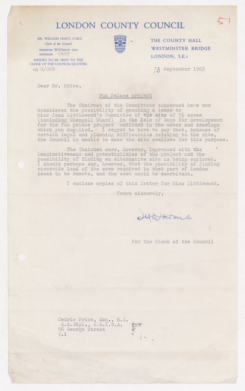
The letter's signatory is illegible, but it is noted that the letter is signed on behalf of the Clerk of the Council. The letter contains information on the Council's decision regarding 54 acres (including Glengall Wharf) in the Isle of Dogs development proposed site for the Fun Palace Project.
DR1995:0188:744
Description:
The letter's signatory is illegible, but it is noted that the letter is signed on behalf of the Clerk of the Council. The letter contains information on the Council's decision regarding 54 acres (including Glengall Wharf) in the Isle of Dogs development proposed site for the Fun Palace Project.
Personnes et institutions:
Date:
13 September 1963
13 September 1963
Titre:
Letter from the London County Council to Cedric Price regarding the Fun Palace Project
Actions:
DR1995:0188:744
Description:
The letter's signatory is illegible, but it is noted that the letter is signed on behalf of the Clerk of the Council. The letter contains information on the Council's decision regarding 54 acres (including Glengall Wharf) in the Isle of Dogs development proposed site for the Fun Palace Project.
Letter from the London County Council to Cedric Price regarding the Fun Palace Project
Actions:
DR1995:0188:744
Description:
The letter's signatory is illegible, but it is noted that the letter is signed on behalf of the Clerk of the Council. The letter contains information on the Council's decision regarding 54 acres (including Glengall Wharf) in the Isle of Dogs development proposed site for the Fun Palace Project.
Classification:
documents textuels
documents textuels
Date:
13 September 1963
13 September 1963
Personnes et institutions:
Classification:
dessins
dessins
Actions:
Numéro de référence:
DR1984:0015
Description:
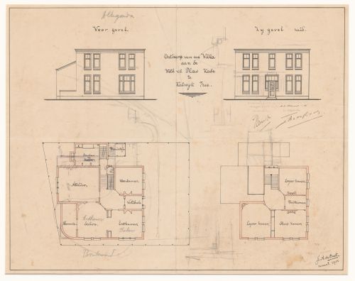
- This contract drawing, by J.A. de Best, shows the west and south elevations, plan and site plan for Villa Sigrid. J.J.P. Oud has sketched graphite revisions for Villa Allegonda ca. 1917 over the south façade and ground plan, and has sketched an unidentified partial section at the bottom.
DR1984:0015
Description:
- This contract drawing, by J.A. de Best, shows the west and south elevations, plan and site plan for Villa Sigrid. J.J.P. Oud has sketched graphite revisions for Villa Allegonda ca. 1917 over the south façade and ground plan, and has sketched an unidentified partial section at the bottom.
Personnes et institutions:
Sujet:
architecture
architecture
Date:
1901, revised ca. 1917
1901, revised ca. 1917
Titre:
Site plan, ground and first floor plans and principal and south elevations for Villa Sigrid annotated with revisions by J.J.P. Oud for Villa Allegonda, Katwijk aan Zee, Netherlands
Actions:
DR1984:0015
Description:
- This contract drawing, by J.A. de Best, shows the west and south elevations, plan and site plan for Villa Sigrid. J.J.P. Oud has sketched graphite revisions for Villa Allegonda ca. 1917 over the south façade and ground plan, and has sketched an unidentified partial section at the bottom.
Site plan, ground and first floor plans and principal and south elevations for Villa Sigrid annotated with revisions by J.J.P. Oud for Villa Allegonda, Katwijk aan Zee, Netherlands
Actions:
DR1984:0015
Description:
- This contract drawing, by J.A. de Best, shows the west and south elevations, plan and site plan for Villa Sigrid. J.J.P. Oud has sketched graphite revisions for Villa Allegonda ca. 1917 over the south façade and ground plan, and has sketched an unidentified partial section at the bottom.
Classification:
dessins
dessins
Date:
1901, revised ca. 1917
1901, revised ca. 1917
Personnes et institutions:
Sujet:
architecture
architecture
Classification:
dessins
dessins
Numéro de référence:
DR1987:0611
Description:
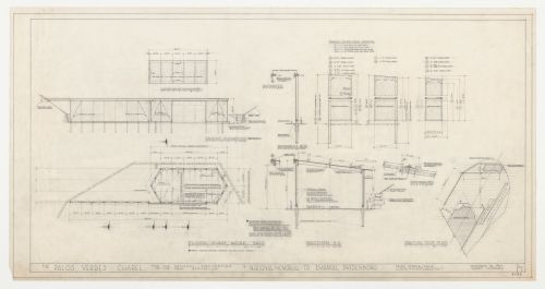
- These drawings for the work shed for Wayfarers' Chapel, Palos Verdes, California, include sections and elevations for sliding door panels of different sizes and a detail showing the roof sheeting. The block plan shows the location of the work shed in relation to nearby buildings on the site.
DR1987:0611
Description:
- These drawings for the work shed for Wayfarers' Chapel, Palos Verdes, California, include sections and elevations for sliding door panels of different sizes and a detail showing the roof sheeting. The block plan shows the location of the work shed in relation to nearby buildings on the site.
Personnes et institutions:
Sujet:
architecture
architecture
Date:
30 October 1957
30 October 1957
Titre:
Wayfarers' Chapel, Palos Verdes, California: Ground plan, section, partial block plan and elevation for the work shed, with sections and elevations for the wooden sliding doors
Actions:
DR1987:0611
Description:
- These drawings for the work shed for Wayfarers' Chapel, Palos Verdes, California, include sections and elevations for sliding door panels of different sizes and a detail showing the roof sheeting. The block plan shows the location of the work shed in relation to nearby buildings on the site.
Wayfarers' Chapel, Palos Verdes, California: Ground plan, section, partial block plan and elevation for the work shed, with sections and elevations for the wooden sliding doors
Actions:
DR1987:0611
Description:
- These drawings for the work shed for Wayfarers' Chapel, Palos Verdes, California, include sections and elevations for sliding door panels of different sizes and a detail showing the roof sheeting. The block plan shows the location of the work shed in relation to nearby buildings on the site.
Classification:
dessins
dessins
Date:
30 October 1957
30 October 1957
Personnes et institutions:
Sujet:
architecture
architecture
Classification:
dessins
dessins
Actions:
Numéro de référence:
DR1984:1341
Description:
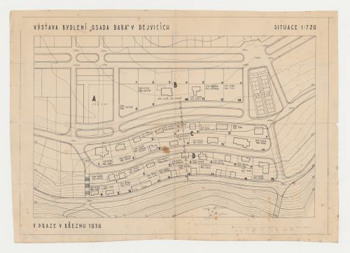
- Lot numbers and the names of the architects and clients are inscribed on this site plan for Baba Villa Colony, Prague, Czechoslovakia (now Czech Republic) (see object file DR1984:1338 - 1366 for a table by J. Viloria listing lot numbers and the names of the architects and clients).
DR1984:1341
Description:
- Lot numbers and the names of the architects and clients are inscribed on this site plan for Baba Villa Colony, Prague, Czechoslovakia (now Czech Republic) (see object file DR1984:1338 - 1366 for a table by J. Viloria listing lot numbers and the names of the architects and clients).
Personnes et institutions:
Sujet:
architecture, urbanisme
architecture, urbanisme
Date:
printed March 1930
printed March 1930
Titre:
Site plan for Baba Villa Colony, Prague, Czechoslovakia (now Czech Republic)
Actions:
DR1984:1341
Description:
- Lot numbers and the names of the architects and clients are inscribed on this site plan for Baba Villa Colony, Prague, Czechoslovakia (now Czech Republic) (see object file DR1984:1338 - 1366 for a table by J. Viloria listing lot numbers and the names of the architects and clients).
Site plan for Baba Villa Colony, Prague, Czechoslovakia (now Czech Republic)
Actions:
DR1984:1341
Description:
- Lot numbers and the names of the architects and clients are inscribed on this site plan for Baba Villa Colony, Prague, Czechoslovakia (now Czech Republic) (see object file DR1984:1338 - 1366 for a table by J. Viloria listing lot numbers and the names of the architects and clients).
Classification:
dessins
dessins
Date:
printed March 1930
printed March 1930
Personnes et institutions:
Sujet:
architecture, urbanisme
architecture, urbanisme
Classification:
photographies
photographies
Numéro de référence:
ARCH274384
Description:
Slides document a competition entry for the Fine Arts Center, Arizona State University in Tempe, Arizona. Includes site photographs, concept diagrams, elevations, section drawings and plans with views and models of the Museum, Theatre, Dance Building and Performance Plaza.
ARCH274384
Description:
Slides document a competition entry for the Fine Arts Center, Arizona State University in Tempe, Arizona. Includes site photographs, concept diagrams, elevations, section drawings and plans with views and models of the Museum, Theatre, Dance Building and Performance Plaza.
Personnes et institutions:
Date:
ca. 1985
ca. 1985
Titre:
Slides documenting a competition entry for the Fine Arts Center, Arizona State University in Tempe, Arizona
Actions:
ARCH274384
Description:
Slides document a competition entry for the Fine Arts Center, Arizona State University in Tempe, Arizona. Includes site photographs, concept diagrams, elevations, section drawings and plans with views and models of the Museum, Theatre, Dance Building and Performance Plaza.
Slides documenting a competition entry for the Fine Arts Center, Arizona State University in Tempe, Arizona
Actions:
ARCH274384
Description:
Slides document a competition entry for the Fine Arts Center, Arizona State University in Tempe, Arizona. Includes site photographs, concept diagrams, elevations, section drawings and plans with views and models of the Museum, Theatre, Dance Building and Performance Plaza.
Classification:
photographies
photographies
Date:
ca. 1985
ca. 1985
Personnes et institutions:
Classification:
dessins, documents textuels
dessins, documents textuels
Numéro de référence:
DR2007:0005:244
Description:
This box contains office project files for Aronoff Center for Design and Art, University of Cincinnati. Files include information on site work, materials, electrical, doors and windows, acoustics, and conveying systems. Original office file numbers have been transcribed on the folders.
DR2007:0005:244
Description:
This box contains office project files for Aronoff Center for Design and Art, University of Cincinnati. Files include information on site work, materials, electrical, doors and windows, acoustics, and conveying systems. Original office file numbers have been transcribed on the folders.
Personnes et institutions:
Date:
circa 1990-1992
circa 1990-1992
Titre:
Project files, Aronoff Center for Design and Art, University of Cincinnati, Ohio
Actions:
DR2007:0005:244
Description:
This box contains office project files for Aronoff Center for Design and Art, University of Cincinnati. Files include information on site work, materials, electrical, doors and windows, acoustics, and conveying systems. Original office file numbers have been transcribed on the folders.
Project files, Aronoff Center for Design and Art, University of Cincinnati, Ohio
Actions:
DR2007:0005:244
Description:
This box contains office project files for Aronoff Center for Design and Art, University of Cincinnati. Files include information on site work, materials, electrical, doors and windows, acoustics, and conveying systems. Original office file numbers have been transcribed on the folders.
Classification:
dessins, documents textuels
dessins, documents textuels
Date:
circa 1990-1992
circa 1990-1992
Personnes et institutions:
Classification:
dessins
dessins
Numéro de référence:
AP140.S2.SS1.D33.P27
Description:
site plans, floor plans for apartments and duplexes, schematic elevations, sections and details, including for mechanical systems, concrete panel ribbing, ramps and footbridges, some maps of Bath and Edinburgh, plans of public spaces and squares in Bath and Edinburgh
AP140.S2.SS1.D33.P27
Description:
site plans, floor plans for apartments and duplexes, schematic elevations, sections and details, including for mechanical systems, concrete panel ribbing, ramps and footbridges, some maps of Bath and Edinburgh, plans of public spaces and squares in Bath and Edinburgh
Personnes et institutions:
Titre:
Site plans, floor plans for apartments and duplexes
Actions:
AP140.S2.SS1.D33.P27
Description:
site plans, floor plans for apartments and duplexes, schematic elevations, sections and details, including for mechanical systems, concrete panel ribbing, ramps and footbridges, some maps of Bath and Edinburgh, plans of public spaces and squares in Bath and Edinburgh
Site plans, floor plans for apartments and duplexes
Actions:
AP140.S2.SS1.D33.P27
Description:
site plans, floor plans for apartments and duplexes, schematic elevations, sections and details, including for mechanical systems, concrete panel ribbing, ramps and footbridges, some maps of Bath and Edinburgh, plans of public spaces and squares in Bath and Edinburgh
Classification:
dessins
dessins
Personnes et institutions:
Classification:
dessins
dessins
Numéro de référence:
AP140.S2.SS1.D70.P151
Description:
Topographic maps of Bilbao, rendered cadastral maps of Bilbao for alternative urban design schemes and superposed site plans of Abando Passenger Interchange over aerial views of Bilbao for first Interchange project, also schematic perspective for Stadium Development in Seville
AP140.S2.SS1.D70.P151
Description:
Topographic maps of Bilbao, rendered cadastral maps of Bilbao for alternative urban design schemes and superposed site plans of Abando Passenger Interchange over aerial views of Bilbao for first Interchange project, also schematic perspective for Stadium Development in Seville
Personnes et institutions:
Date:
circa 1974-1999
circa 1974-1999
Titre:
Topographic maps of Bilbao, rendered cadastral maps of Bilbao, Abando Passenger Interchange, Bilbao, Spain
Actions:
AP140.S2.SS1.D70.P151
Description:
Topographic maps of Bilbao, rendered cadastral maps of Bilbao for alternative urban design schemes and superposed site plans of Abando Passenger Interchange over aerial views of Bilbao for first Interchange project, also schematic perspective for Stadium Development in Seville
Topographic maps of Bilbao, rendered cadastral maps of Bilbao, Abando Passenger Interchange, Bilbao, Spain
Actions:
AP140.S2.SS1.D70.P151
Description:
Topographic maps of Bilbao, rendered cadastral maps of Bilbao for alternative urban design schemes and superposed site plans of Abando Passenger Interchange over aerial views of Bilbao for first Interchange project, also schematic perspective for Stadium Development in Seville
Classification:
dessins
dessins
Date:
circa 1974-1999
circa 1974-1999
Personnes et institutions:


