5646 Résultats
Classification:
dessins
Quantité:
25 conceptual drawing(s)
dessins
Quantité:
25 conceptual drawing(s)
Numéro de référence:
DR1995:0255:154-178
Description:
ordnance maps showing sketch proposals, schematic plans, sketch sections, plans, diagrammatic plans showing land use and development phases, and layout plan
DR1995:0255:154-178
Description:
ordnance maps showing sketch proposals, schematic plans, sketch sections, plans, diagrammatic plans showing land use and development phases, and layout plan
Personnes et institutions:
Titre:
Ordnance maps showing sketch proposals, schematic plans
Actions:
DR1995:0255:154-178
Description:
ordnance maps showing sketch proposals, schematic plans, sketch sections, plans, diagrammatic plans showing land use and development phases, and layout plan
Ordnance maps showing sketch proposals, schematic plans
Actions:
DR1995:0255:154-178
Description:
ordnance maps showing sketch proposals, schematic plans, sketch sections, plans, diagrammatic plans showing land use and development phases, and layout plan
Classification:
dessins
Quantité:
25 conceptual drawing(s)
dessins
Quantité:
25 conceptual drawing(s)
Personnes et institutions:
Classification:
archives
Niveau de description archivistique:
Fonds
archives
Niveau de description archivistique:
Fonds
Numéro de référence:
AP051
Résumé:
The Groupe de recherche sur Montréal fonds, 1975-1997, documents the Groupe de recherche sur Montréal’s (GRM) extensive research on the development of pre and post-industrial Montreal’s built environment. In addition to this extensive collection of research materials, the fonds also includes administrative files relating to the GRM’s everyday administration and management. Materials found in this fonds consist of approximately 40 l.m. of textual documentation, approximately 2000 maps and 1 model.
Personnes et institutions:
Date:
1975-1997
1975-1997
Titre:
Fonds Groupe de recherche sur Montréal
Actions:
AP051
Résumé:
The Groupe de recherche sur Montréal fonds, 1975-1997, documents the Groupe de recherche sur Montréal’s (GRM) extensive research on the development of pre and post-industrial Montreal’s built environment. In addition to this extensive collection of research materials, the fonds also includes administrative files relating to the GRM’s everyday administration and management. Materials found in this fonds consist of approximately 40 l.m. of textual documentation, approximately 2000 maps and 1 model.
Classification:
archives
Niveau de description archivistique:
Fonds
archives
Niveau de description archivistique:
Fonds
Date:
1975-1997
1975-1997
Personnes et institutions:
Classification:
documents textuels
documents textuels
Numéro de référence:
ARCH285512
Description:
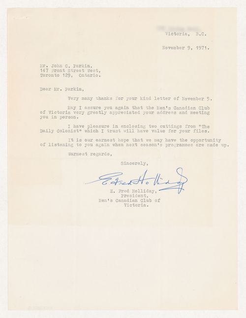
Clippings from 2 articles on Parkin's address to the club: "Architect's Advice to City: Over-all Plan, Land Banks;" and "Let's Redirect Technology."
ARCH285512
Description:
Clippings from 2 articles on Parkin's address to the club: "Architect's Advice to City: Over-all Plan, Land Banks;" and "Let's Redirect Technology."
Personnes et institutions:
Date:
9 November 1971
9 November 1971
Titre:
Letter from the President of the Men's Canadian Club of Victoria to thank Parkin with 2 clippings of the Daily Colonist enclosed
Actions:
ARCH285512
Description:
Clippings from 2 articles on Parkin's address to the club: "Architect's Advice to City: Over-all Plan, Land Banks;" and "Let's Redirect Technology."
Classification:
documents textuels
documents textuels
Date:
9 November 1971
9 November 1971
Personnes et institutions:
Niveau de description archivistique:
Projet
Projet
Numéro de référence:
AP027.S1.D69
Description:
Preliminary master plan for the development of a new town. The St-Basile-le-Grand site is approximately 1,000 acres and is located 13 miles east of Montréal between two existing towns. Project includes housing, demographic, and transportation studies, private investment development, and management manuals for client. The commission proposes a close-knit community with agricultural land preserved and held in condominium by each householder.
Personnes et institutions:
Sujet:
urbanisme
urbanisme
Date:
1975-1977
1975-1977
Titre:
La Forêt, St. Basile Le-Grand
Actions:
AP027.S1.D69
Description:
Preliminary master plan for the development of a new town. The St-Basile-le-Grand site is approximately 1,000 acres and is located 13 miles east of Montréal between two existing towns. Project includes housing, demographic, and transportation studies, private investment development, and management manuals for client. The commission proposes a close-knit community with agricultural land preserved and held in condominium by each householder.
Niveau de description archivistique:
File 69
File 69
Date:
1975-1977
1975-1977
Personnes et institutions:
Sujet:
urbanisme
urbanisme
Niveau de description archivistique:
Projet
Projet
Titre:
Old Montréal
Old Montréal
Numéro de référence:
AP027.S1.D17
Description:
Study and plan for the rehabilitation of the Old City of Montréal. The study assesses the historical importance of the Old City and examines existing conditions of land use, circulation, parking, the present condition of buildings, property values and the architectural merit of the structures. Proposals and recommendations are summarized in the report. Reconstruction of the plans of the Old City of Montréal at significant stages of development up to 1962, from archival records.
Personnes et institutions:
Sujet:
urbanisme
urbanisme
Date:
1961-1963
1961-1963
Titre:
Old Montréal
Actions:
AP027.S1.D17
Description:
Study and plan for the rehabilitation of the Old City of Montréal. The study assesses the historical importance of the Old City and examines existing conditions of land use, circulation, parking, the present condition of buildings, property values and the architectural merit of the structures. Proposals and recommendations are summarized in the report. Reconstruction of the plans of the Old City of Montréal at significant stages of development up to 1962, from archival records.
Niveau de description archivistique:
File 17
File 17
Date:
1961-1963
1961-1963
Personnes et institutions:
Sujet:
urbanisme
urbanisme
Classification:
dessins
dessins
Numéro de référence:
DR2004:0719
Description:
drawings by British Railways, plans, site plans, consultant`s drawings, land surveys, details, elevations, sections, axonometric, and drawing possibly from the Anglia project
DR2004:0719
Description:
drawings by British Railways, plans, site plans, consultant`s drawings, land surveys, details, elevations, sections, axonometric, and drawing possibly from the Anglia project
Personnes et institutions:
Titre:
Drawings by British Railways, plans, site plans, consultant`s drawings
Actions:
DR2004:0719
Description:
drawings by British Railways, plans, site plans, consultant`s drawings, land surveys, details, elevations, sections, axonometric, and drawing possibly from the Anglia project
Drawings by British Railways, plans, site plans, consultant`s drawings
Actions:
DR2004:0719
Description:
drawings by British Railways, plans, site plans, consultant`s drawings, land surveys, details, elevations, sections, axonometric, and drawing possibly from the Anglia project
Classification:
dessins
dessins
Personnes et institutions:
Niveau de description archivistique:
Projet
Projet
Numéro de référence:
AP206.S1.1997.PR02
Description:
This project series documents a residence for Dr. PS Bidwai in Chandigarh, India in 1997. This project consisted of the intermediary stage for the building, as the first stage had already been constructed. Located on plot no. 1224 in Sector 42B, the three-storey, three bedroom home was on a 2250 square foot plot of land. The project is recorded through drawings of site and floor plans, elevations and a section dating from 1997.
Personnes et institutions:
Date:
1997
1997
Titre:
Residence for Dr. PS Bidwai, Chandigarh, India (1997)
Actions:
AP206.S1.1997.PR02
Description:
This project series documents a residence for Dr. PS Bidwai in Chandigarh, India in 1997. This project consisted of the intermediary stage for the building, as the first stage had already been constructed. Located on plot no. 1224 in Sector 42B, the three-storey, three bedroom home was on a 2250 square foot plot of land. The project is recorded through drawings of site and floor plans, elevations and a section dating from 1997.
Niveau de description archivistique:
Project
Project
Date:
1997
1997
Personnes et institutions:
Classification:
dessins
Quantité:
56 design development drawing(s)
dessins
Quantité:
56 design development drawing(s)
Numéro de référence:
DR2004:0789
Description:
site plans, some with annotations, sections, elevations, land surveys, overlays, reference drawings, sketches, diagrams, schematics, maps, plans, aerial photographs of sites, invoice, and receipt
DR2004:0789
Description:
site plans, some with annotations, sections, elevations, land surveys, overlays, reference drawings, sketches, diagrams, schematics, maps, plans, aerial photographs of sites, invoice, and receipt
Personnes et institutions:
Titre:
Site plans, some with annotations, sections, elevations
Actions:
DR2004:0789
Description:
site plans, some with annotations, sections, elevations, land surveys, overlays, reference drawings, sketches, diagrams, schematics, maps, plans, aerial photographs of sites, invoice, and receipt
Site plans, some with annotations, sections, elevations
Actions:
DR2004:0789
Description:
site plans, some with annotations, sections, elevations, land surveys, overlays, reference drawings, sketches, diagrams, schematics, maps, plans, aerial photographs of sites, invoice, and receipt
Classification:
dessins
Quantité:
56 design development drawing(s)
dessins
Quantité:
56 design development drawing(s)
Personnes et institutions:
Niveau de description archivistique:
Projet
Projet
Numéro de référence:
AP027.S1.D13
Description:
Preliminary study of downtown transportation and its relation to the central area of Montréal. The study analyzes the requirements for major vehicular circulation in the central Area and access to it. The general system of rapid transit routes, major pedestrian routes, parking policy and, land use in the central area are also examined. The proposals were accepted by the City of Montréal as the working documents of the City Planning Department and several proposals were implemented.
Personnes et institutions:
Date:
1957-1960
1957-1960
Titre:
Central Area Circulation, Montreal
Actions:
AP027.S1.D13
Description:
Preliminary study of downtown transportation and its relation to the central area of Montréal. The study analyzes the requirements for major vehicular circulation in the central Area and access to it. The general system of rapid transit routes, major pedestrian routes, parking policy and, land use in the central area are also examined. The proposals were accepted by the City of Montréal as the working documents of the City Planning Department and several proposals were implemented.
Niveau de description archivistique:
File 13
File 13
Date:
1957-1960
1957-1960
Personnes et institutions:
Classification:
documents textuels
documents textuels
Numéro de référence:
DR1999:0458
Description:
documents include a Design Development Lab Fit Out, estimates, correspondence, transmittals, memos, timeline, land development plan, Carnegie directory, CMRI program (bound text), floor plans
DR1999:0458
Description:
documents include a Design Development Lab Fit Out, estimates, correspondence, transmittals, memos, timeline, land development plan, Carnegie directory, CMRI program (bound text), floor plans
Personnes et institutions:
Titre:
Estimates, correspondence and other administrative records for Carnegie Mellon Research Institute
Actions:
DR1999:0458
Description:
documents include a Design Development Lab Fit Out, estimates, correspondence, transmittals, memos, timeline, land development plan, Carnegie directory, CMRI program (bound text), floor plans
Classification:
documents textuels
documents textuels
Personnes et institutions: