7466 Résultats
Niveau de description archivistique:
Projet
Projet
Titre:
BAA/LHA/North
BAA/LHA/North
Numéro de référence:
AP144.S2.D65
Description:
File documents several commissions undertaken for the British Airports Authority for the re-development of the north side of Heathrow Airport, in Hillingdon, Greater London, England, United Kingdom, with respect to the revision of BAA's Master Development Plan. Cedric Price was commissioned to present proposals for the redevelopment of the site, and for an office block, a computer center, and a boiler house. Existing conditions materials for the site include plans of the airport, plans showing height limitations, flight, and landing paths, a regional survey, aerial photographs, and a photographic panorama of the site. Existing conditions materials for the office block include site plans. Diagrammatic sketches show the relationship between various "activity" zones. Design development drawings and reprographic copies for the site include alternate site plans, site plans charting sound levels, and project progress charts. Plans show traffic flow and growth patterns, area usage, height restrictions, and potential long-term uses for the site. Design development drawings for the office block include a preliminary structural scheme, alternate office layouts, axonometric drawings, plans, sections and diagrams for the lift, graphs showing parking ratios, a diagrammatic section and grid for a parking layout, and plans, sections and diagrams for the parking structure and building entrances. Axonometric drawings show volumetric comparisons for areas designated for computers and their use. Material for the boiler house consists of two existing conditions plans, a location diagram, and an axonometric drawing. Cedric Price produced two reports for the British Airport Authority. Material from this file was published in Price, Cedric. 'Cedric Price-Works II' (London: Architectural Press, 1984), 43. Material in this file was produced between 1963 and 1970. Douglas Smith, of Baker Wilkins & Smith, is Cedric Price's quantity surveyor on this project; Margaret Maxwell is the landscape consultant hired by BAA; and Zisman, Bowyer & Partners is the firm of consulting engineers hired by BAA. File contains conceptual drawings, design development drwings, reference drawings, presentation drawings, photographic materials, and textual records.
Personnes et institutions:
Date:
1963-1970
1963-1970
Titre:
BAA/LHA/North
Actions:
AP144.S2.D65
Description:
File documents several commissions undertaken for the British Airports Authority for the re-development of the north side of Heathrow Airport, in Hillingdon, Greater London, England, United Kingdom, with respect to the revision of BAA's Master Development Plan. Cedric Price was commissioned to present proposals for the redevelopment of the site, and for an office block, a computer center, and a boiler house. Existing conditions materials for the site include plans of the airport, plans showing height limitations, flight, and landing paths, a regional survey, aerial photographs, and a photographic panorama of the site. Existing conditions materials for the office block include site plans. Diagrammatic sketches show the relationship between various "activity" zones. Design development drawings and reprographic copies for the site include alternate site plans, site plans charting sound levels, and project progress charts. Plans show traffic flow and growth patterns, area usage, height restrictions, and potential long-term uses for the site. Design development drawings for the office block include a preliminary structural scheme, alternate office layouts, axonometric drawings, plans, sections and diagrams for the lift, graphs showing parking ratios, a diagrammatic section and grid for a parking layout, and plans, sections and diagrams for the parking structure and building entrances. Axonometric drawings show volumetric comparisons for areas designated for computers and their use. Material for the boiler house consists of two existing conditions plans, a location diagram, and an axonometric drawing. Cedric Price produced two reports for the British Airport Authority. Material from this file was published in Price, Cedric. 'Cedric Price-Works II' (London: Architectural Press, 1984), 43. Material in this file was produced between 1963 and 1970. Douglas Smith, of Baker Wilkins & Smith, is Cedric Price's quantity surveyor on this project; Margaret Maxwell is the landscape consultant hired by BAA; and Zisman, Bowyer & Partners is the firm of consulting engineers hired by BAA. File contains conceptual drawings, design development drwings, reference drawings, presentation drawings, photographic materials, and textual records.
Niveau de description archivistique:
File 65
File 65
Date:
1963-1970
1963-1970
Personnes et institutions:
Classification:
événements
événements

Description:
Rebecca Solnit, chercheur principal et boursier Mellon au CCA en 2008, est une écrivaine indépendante, une historienne et activiste avec un intérêt marqué pour la géographie, le paysage, les thèmes de la lenteur, de l’insurrection, la photographie, les trajectoires indirectes et les sujets inclassables. Elle réside à San Francisco et a reçu de nombreux prix, incluant le(...)
Rebecca Solnit, chercheur principal et boursier Mellon au CCA en 2008, est une écrivaine indépendante, une historienne et activiste avec un intérêt marqué pour la géographie, le paysage, les thèmes de la lenteur, de l’insurrection, la photographie, les trajectoires indirectes et les sujets inclassables. Elle réside à San Francisco et a reçu de nombreux prix, incluant le(...)
Date:
9 octobre 2008
9 octobre 2008
Titre:
Rebecca Solnit : The Ruins of Hope, Hope in the Ruins
Actions:
Description:
Rebecca Solnit, chercheur principal et boursier Mellon au CCA en 2008, est une écrivaine indépendante, une historienne et activiste avec un intérêt marqué pour la géographie, le paysage, les thèmes de la lenteur, de l’insurrection, la photographie, les trajectoires indirectes et les sujets inclassables. Elle réside à San Francisco et a reçu de nombreux prix, incluant le(...)
Classification:
événements
événements
Date:
9 octobre 2008
9 octobre 2008
Niveau de description archivistique:
Projet
Projet
Numéro de référence:
AP018.S1.1972.PR18
Description:
This project series documents the design and construction of a library and an addition to city hall in Fredericton, New Brunswick from 1972-1975. The office identified the project number as 7226. This project consisted of two distinct parts; a public library constructed at the corners of Campbell and Carleton Streets, and an addition to city hall whose original building was constructed at the corners of Queen and York Streets around 1875. These two buildings were located two blocks from one another, but a master plan for the project shows that the separating streets would be removed in favour of a pedestrian friendly landscape. Both buildings were located next to the St. John River. For this project, Parkin Architects Planners partnered with architectural firm Graham Napier Associates to form the joint venture referred to as Graham Parkin Architects Engineers Planners. The brick-clad addition to city hall nearly doubled the square footage of the ground and first floors. The original city hall was four levels and the addition was two, with a mechanical penthouse on top. The new areas included departmental offices such as planning, engineering and sewage, a drafting room, conference room, and reception, among others. The library consisted of a two-storey, brick-clad building that was approximately 24,000 square feet in size with a 16 car parking lot. The ground floor included reception and exhibit areas, stacks, administration offices, bookmobiles, and staff lockers, while the second level had stacks and reading areas, audiovisual areas and a staff work room and break room. The library also had a mechanical penthouse on top. The project is recorded through drawings, including mounted presentation boards, photographic materials and textual records dating from 1972-1978. The drawings consist of original sketches, plans, sections, elevations and details of both city hall and the library, and some drawings used for construction. There are also drawings of the original city hall, first drafted around 1875. The photographs show existing buildings and the construction progress of the project. The textual records consist of correspondence, conference reports, interoffice letters, specifications, consultancy documentation, a soil investigation, research and drawing transmittal records. File AP018.S1.1972.PR18.020 contains an index to the textual materials, which was created by the office.
Personnes et institutions:
Date:
circa 1972-1978
circa 1972-1978
Titre:
City Hall and Library Facilities, Fredericton, New Brunswick (1972-1975)
Actions:
AP018.S1.1972.PR18
Description:
This project series documents the design and construction of a library and an addition to city hall in Fredericton, New Brunswick from 1972-1975. The office identified the project number as 7226. This project consisted of two distinct parts; a public library constructed at the corners of Campbell and Carleton Streets, and an addition to city hall whose original building was constructed at the corners of Queen and York Streets around 1875. These two buildings were located two blocks from one another, but a master plan for the project shows that the separating streets would be removed in favour of a pedestrian friendly landscape. Both buildings were located next to the St. John River. For this project, Parkin Architects Planners partnered with architectural firm Graham Napier Associates to form the joint venture referred to as Graham Parkin Architects Engineers Planners. The brick-clad addition to city hall nearly doubled the square footage of the ground and first floors. The original city hall was four levels and the addition was two, with a mechanical penthouse on top. The new areas included departmental offices such as planning, engineering and sewage, a drafting room, conference room, and reception, among others. The library consisted of a two-storey, brick-clad building that was approximately 24,000 square feet in size with a 16 car parking lot. The ground floor included reception and exhibit areas, stacks, administration offices, bookmobiles, and staff lockers, while the second level had stacks and reading areas, audiovisual areas and a staff work room and break room. The library also had a mechanical penthouse on top. The project is recorded through drawings, including mounted presentation boards, photographic materials and textual records dating from 1972-1978. The drawings consist of original sketches, plans, sections, elevations and details of both city hall and the library, and some drawings used for construction. There are also drawings of the original city hall, first drafted around 1875. The photographs show existing buildings and the construction progress of the project. The textual records consist of correspondence, conference reports, interoffice letters, specifications, consultancy documentation, a soil investigation, research and drawing transmittal records. File AP018.S1.1972.PR18.020 contains an index to the textual materials, which was created by the office.
Niveau de description archivistique:
Project
Project
Date:
circa 1972-1978
circa 1972-1978
Personnes et institutions:
Classification:
archives
Niveau de description archivistique:
Fonds
archives
Niveau de description archivistique:
Fonds
Numéro de référence:
AP192
Résumé:
The Morphosis Hypo Alpe-Adria Center project records, 1996 – 2016, consist of over 14,000 born-digital files that document the design and construction of the Austrian Hypo Alpe-Adria Bank group’s headquarters in Klagenfurt, Austria. Series 1, Competition and design, includes files showing early conceptualization of the project through the final design documentation. Series 2, Construction documentation, largely contains drawings and photographs which demonstrate the progress of the project in the built environment over time. Formats chiefly include CAD files (PowerCAD, PowerDraw, Microstation, DXF, AutoCAD, PLT), 3D models (Form*Z, STL), images, and text.
Personnes et institutions:
Date:
1996 - 2016
1996 - 2016
Titre:
Documents d’archives de Morphosis pour le projet Centre Hypo Alpe-Adria
Actions:
AP192
Résumé:
The Morphosis Hypo Alpe-Adria Center project records, 1996 – 2016, consist of over 14,000 born-digital files that document the design and construction of the Austrian Hypo Alpe-Adria Bank group’s headquarters in Klagenfurt, Austria. Series 1, Competition and design, includes files showing early conceptualization of the project through the final design documentation. Series 2, Construction documentation, largely contains drawings and photographs which demonstrate the progress of the project in the built environment over time. Formats chiefly include CAD files (PowerCAD, PowerDraw, Microstation, DXF, AutoCAD, PLT), 3D models (Form*Z, STL), images, and text.
Classification:
archives
Niveau de description archivistique:
Fonds
archives
Niveau de description archivistique:
Fonds
Date:
1996 - 2016
1996 - 2016
Personnes et institutions:
Niveau de description archivistique:
Série(s)
Série(s)
Numéro de référence:
AP175.S1
Description:
Series 1, Erasmus Bridge, Rotterdam, Netherlands, 1990-1996, documents the design, conception and construction of a third bridge for Rotterdam over the Nieuwe Maas River. The bridge connects the Kop van Zuid neighborhood, located on the south side of the river, to Willemsplein, located on the north side. The bridge is considered as a landmark in Rotterdam’s landscape. The Erasmus Bridge was a formative project in the thinking of UNStudio. It was originally supposed to be designed by architect Maarten Struijs who was the city of Rotterdam principal architect and who is responsible for the concept of the neighboring Willem Bridge. Ben van Berkel came later into the project and was hired as a designing consultant along with architect Wim Quist. Ben van Berkel proposed design was selected allowing him and his firm, which was called Van Berkel & Bos Architectuurbureau at that time, to supervise the conception and construction of the project, from the original concept to piers design to the selection of every item of bridge furniture such as traffic lights, bridge camera and handrails. The bridge was designed to fit the distinct character and industrial past of Rotterdam. The construction of this landmark was one component of a larger redevelopment project, coinciding with other major developments in the city of Rotterdam. The goal was to develop a dense urban intervention on the southern shore of the Nieuwe Maas, in the Kop van Zuid neighborhood. This explains the implication of UNStudio in the planning of urban configuration of the neighborhoods on both sides of the river and their work for Spido, a ferry company operating on the Nieuwe Maas, work spaces and parking garage. This commercial building was designed by the firm and also hosts The Grand Café and Jazz Café. This commercial building is integrated to one of the bridge pillar on the north shore of the river. For the design the firm used AutoCAD to work along with engineers and to conceptualize 3D models. They also used the software to evaluate the circulation flow of drivers, pedestrians and streetcars, measuring its impact on the structure and the urban configuration of the neighborhoods on both sides of the river. The records contain sketches for bridge and pier design, plans and sections for pier, Spido and bridge, architectural and construction details created by engineering companies for every component of the bridge, from drawbridge, to cable car system, to bridge furnitures such as traffic light, handrails and cameras and photographs documenting the research for precedent and the original configuration of the neighborhoods on both sides of the river. The record contains AutoCAD plans, details and sections for both the bridge and Spido parking garage. The records also contain one physical model: a small scale plastic, glass and metal model of the bridge.
Personnes et institutions:
Date:
1990-1996
1990-1996
Titre:
Erasmus Bridge, Rotterdam, Netherlands, 1990-1996
Actions:
AP175.S1
Description:
Series 1, Erasmus Bridge, Rotterdam, Netherlands, 1990-1996, documents the design, conception and construction of a third bridge for Rotterdam over the Nieuwe Maas River. The bridge connects the Kop van Zuid neighborhood, located on the south side of the river, to Willemsplein, located on the north side. The bridge is considered as a landmark in Rotterdam’s landscape. The Erasmus Bridge was a formative project in the thinking of UNStudio. It was originally supposed to be designed by architect Maarten Struijs who was the city of Rotterdam principal architect and who is responsible for the concept of the neighboring Willem Bridge. Ben van Berkel came later into the project and was hired as a designing consultant along with architect Wim Quist. Ben van Berkel proposed design was selected allowing him and his firm, which was called Van Berkel & Bos Architectuurbureau at that time, to supervise the conception and construction of the project, from the original concept to piers design to the selection of every item of bridge furniture such as traffic lights, bridge camera and handrails. The bridge was designed to fit the distinct character and industrial past of Rotterdam. The construction of this landmark was one component of a larger redevelopment project, coinciding with other major developments in the city of Rotterdam. The goal was to develop a dense urban intervention on the southern shore of the Nieuwe Maas, in the Kop van Zuid neighborhood. This explains the implication of UNStudio in the planning of urban configuration of the neighborhoods on both sides of the river and their work for Spido, a ferry company operating on the Nieuwe Maas, work spaces and parking garage. This commercial building was designed by the firm and also hosts The Grand Café and Jazz Café. This commercial building is integrated to one of the bridge pillar on the north shore of the river. For the design the firm used AutoCAD to work along with engineers and to conceptualize 3D models. They also used the software to evaluate the circulation flow of drivers, pedestrians and streetcars, measuring its impact on the structure and the urban configuration of the neighborhoods on both sides of the river. The records contain sketches for bridge and pier design, plans and sections for pier, Spido and bridge, architectural and construction details created by engineering companies for every component of the bridge, from drawbridge, to cable car system, to bridge furnitures such as traffic light, handrails and cameras and photographs documenting the research for precedent and the original configuration of the neighborhoods on both sides of the river. The record contains AutoCAD plans, details and sections for both the bridge and Spido parking garage. The records also contain one physical model: a small scale plastic, glass and metal model of the bridge.
Niveau de description archivistique:
Series
Series
Date:
1990-1996
1990-1996
Personnes et institutions:
Classification:
archives
Niveau de description archivistique:
Fonds
archives
Niveau de description archivistique:
Fonds
Titre:
Fonds Milton Parc
Fonds Milton Parc
Numéro de référence:
AP025
Résumé:
The Milton Parc fonds, 1969 – 1989, documents the Société du patrimoine urbaine de Montréal’s (SPUM) planning, design and renovation of Montreal’s historic Milton Parc neighbourhood. Recognized as one of the largest co-operative rehabilitation projects completed in Canada, the Milton Parc housing project (1979-1982) renovated over 135 historic buildings and 597 dwelling units within Milton Parc’s 6-block radius. The fonds consists of the following materials: approximately 600 drawings, 85 l.m. of textual records, 0.6 l.m. of slides, 0.6 l.m.of photographs, 8 posters, 3 seals, 2 models, 2 rubber stamps, and 2 audio cassettes.
Personnes et institutions:
Date:
1962-1989
1962-1989
Titre:
Fonds Milton Parc
Actions:
AP025
Résumé:
The Milton Parc fonds, 1969 – 1989, documents the Société du patrimoine urbaine de Montréal’s (SPUM) planning, design and renovation of Montreal’s historic Milton Parc neighbourhood. Recognized as one of the largest co-operative rehabilitation projects completed in Canada, the Milton Parc housing project (1979-1982) renovated over 135 historic buildings and 597 dwelling units within Milton Parc’s 6-block radius. The fonds consists of the following materials: approximately 600 drawings, 85 l.m. of textual records, 0.6 l.m. of slides, 0.6 l.m.of photographs, 8 posters, 3 seals, 2 models, 2 rubber stamps, and 2 audio cassettes.
Classification:
archives
Niveau de description archivistique:
Fonds
archives
Niveau de description archivistique:
Fonds
Date:
1962-1989
1962-1989
Personnes et institutions:
Classification:
archives
Niveau de description archivistique:
Fonds
archives
Niveau de description archivistique:
Fonds
Titre:
Fonds Van Ginkel Associates
Fonds Van Ginkel Associates
Numéro de référence:
AP027
Résumé:
The Van Ginkel Associates fonds is comprised of documents concerning van Ginkel Associates, van Ginkel Associates Ltd., Ecos Ltd., van Ginkel Partners, Ginkelvan Ltd, van Ginkel Associates Ltd. (1977), the styles under which H.P. van Ginkel and Blanche Lemco van Ginkel practiced as a multidisciplinary planning, management and architecture firm. Much of the van Ginkels' work was done in the Montréal area and nation-wide. The fonds contains approximately 1 985 drawings (1 420 originals plus 565 reproductions), 41 boards, 3 photographs, 2 collages, 2 typescripts, 1 model, 1 sketchbook and approximately 12.23 meters of textual documents. The documents were primarily produced between 1955 and 1980.
Personnes et institutions:
Date:
1944-1992
1944-1992
Titre:
Fonds Van Ginkel Associates
Actions:
AP027
Résumé:
The Van Ginkel Associates fonds is comprised of documents concerning van Ginkel Associates, van Ginkel Associates Ltd., Ecos Ltd., van Ginkel Partners, Ginkelvan Ltd, van Ginkel Associates Ltd. (1977), the styles under which H.P. van Ginkel and Blanche Lemco van Ginkel practiced as a multidisciplinary planning, management and architecture firm. Much of the van Ginkels' work was done in the Montréal area and nation-wide. The fonds contains approximately 1 985 drawings (1 420 originals plus 565 reproductions), 41 boards, 3 photographs, 2 collages, 2 typescripts, 1 model, 1 sketchbook and approximately 12.23 meters of textual documents. The documents were primarily produced between 1955 and 1980.
Classification:
archives
Niveau de description archivistique:
Fonds
archives
Niveau de description archivistique:
Fonds
Date:
1944-1992
1944-1992
Personnes et institutions:
Classification:
archives
Niveau de description archivistique:
Fonds
archives
Niveau de description archivistique:
Fonds
Numéro de référence:
AP051
Résumé:
The Groupe de recherche sur Montréal fonds, 1975-1997, documents the Groupe de recherche sur Montréal’s (GRM) extensive research on the development of pre and post-industrial Montreal’s built environment. In addition to this extensive collection of research materials, the fonds also includes administrative files relating to the GRM’s everyday administration and management. Materials found in this fonds consist of approximately 40 l.m. of textual documentation, approximately 2000 maps and 1 model.
Personnes et institutions:
Date:
1975-1997
1975-1997
Titre:
Fonds Groupe de recherche sur Montréal
Actions:
AP051
Résumé:
The Groupe de recherche sur Montréal fonds, 1975-1997, documents the Groupe de recherche sur Montréal’s (GRM) extensive research on the development of pre and post-industrial Montreal’s built environment. In addition to this extensive collection of research materials, the fonds also includes administrative files relating to the GRM’s everyday administration and management. Materials found in this fonds consist of approximately 40 l.m. of textual documentation, approximately 2000 maps and 1 model.
Classification:
archives
Niveau de description archivistique:
Fonds
archives
Niveau de description archivistique:
Fonds
Date:
1975-1997
1975-1997
Personnes et institutions:
Classification:
événements
événements
Titre:
L’enseignement de… Bahreïn
L’enseignement de… Bahreïn
Actions:
Description:
Noura al Sayeh présente la troisième conférence de la série L’enseignement du… Moyen-Orient. La présentation portera sur la documentation photographique de la côte de Bahreïn par le photographe Camille Zakharia. Les transformations des 30 dernières années ont redessiné le paysage urbain bahreïni et entraîné le développement d’une culture vernaculaire contemporaine. On y(...)
Noura al Sayeh présente la troisième conférence de la série L’enseignement du… Moyen-Orient. La présentation portera sur la documentation photographique de la côte de Bahreïn par le photographe Camille Zakharia. Les transformations des 30 dernières années ont redessiné le paysage urbain bahreïni et entraîné le développement d’une culture vernaculaire contemporaine. On y(...)
Localisation:
Théâtre Paul-Desmarais
Théâtre Paul-Desmarais
Date:
6 octobre 2011 , 19h
6 octobre 2011 , 19h
Titre:
L’enseignement de… Bahreïn
Actions:
Description:
Noura al Sayeh présente la troisième conférence de la série L’enseignement du… Moyen-Orient. La présentation portera sur la documentation photographique de la côte de Bahreïn par le photographe Camille Zakharia. Les transformations des 30 dernières années ont redessiné le paysage urbain bahreïni et entraîné le développement d’une culture vernaculaire contemporaine. On y(...)
Classification:
événements
événements
Date:
6 octobre 2011
19h
6 octobre 2011
19h
Localisation:
Théâtre Paul-Desmarais
Théâtre Paul-Desmarais
Classification:
événements
événements
Actions:
Description:
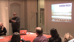
Paysages éphémères et installations éclair ne cessent de prendre de l’ampleur, remettant en question le concept de la ville en tant qu’entité permanente stable. Dans cette conférence, Rahul Mehrotra, associé principal de la firme RMA Architects et directeur de l’École d’urbanisme et de design à la Harvard Graduate School of Design, présente ses recherches sur une(...)
Paysages éphémères et installations éclair ne cessent de prendre de l’ampleur, remettant en question le concept de la ville en tant qu’entité permanente stable. Dans cette conférence, Rahul Mehrotra, associé principal de la firme RMA Architects et directeur de l’École d’urbanisme et de design à la Harvard Graduate School of Design, présente ses recherches sur une(...)
Localisation:
Maison Shaughnessy
Maison Shaughnessy
Date:
13 février 2013 au 12 février 2013
13 février 2013 au 12 février 2013
Titre:
Rahul Mehrotra : La Kumbh Mela en Inde
Actions:
Description:
Paysages éphémères et installations éclair ne cessent de prendre de l’ampleur, remettant en question le concept de la ville en tant qu’entité permanente stable. Dans cette conférence, Rahul Mehrotra, associé principal de la firme RMA Architects et directeur de l’École d’urbanisme et de design à la Harvard Graduate School of Design, présente ses recherches sur une(...)
Classification:
événements
événements
Date:
13 février 2013 au
12 février 2013
13 février 2013 au
12 février 2013
Localisation:
Maison Shaughnessy
Maison Shaughnessy