


3978 Résultats
Classification:
dessins
dessins
Actions:
Numéro de référence:
DR1981:0024
Description:
- DR1981:0024 shows a design for what appears to be an ornamental footbridge. No dimensions are given and materials are not indicated, but the structure could not have been erected at a very large scale. The road bed consists of three sections: a central flat section supported on a broad flat arch; and two gently-sloped side sections, each supported on seven small, round-headed arches. The span of the bridge is braced between two sets of double piers. Each of these four piers carries an octagonal kiosk consisting of closed panels below and an open framework above. At the centre of the bridge rises a pavilion formed of sixteen columns on a rectangular plan (six columns on each of the two long sides) supporting a curved gable roof. Above the road bed, the superstructure is decorated with banners, lanterns, fretwork, and inscriptions, all in a style of Chinese derivation.
DR1981:0024
Description:
- DR1981:0024 shows a design for what appears to be an ornamental footbridge. No dimensions are given and materials are not indicated, but the structure could not have been erected at a very large scale. The road bed consists of three sections: a central flat section supported on a broad flat arch; and two gently-sloped side sections, each supported on seven small, round-headed arches. The span of the bridge is braced between two sets of double piers. Each of these four piers carries an octagonal kiosk consisting of closed panels below and an open framework above. At the centre of the bridge rises a pavilion formed of sixteen columns on a rectangular plan (six columns on each of the two long sides) supporting a curved gable roof. Above the road bed, the superstructure is decorated with banners, lanterns, fretwork, and inscriptions, all in a style of Chinese derivation.
Personnes et institutions:
Sujet:
architecture, architecture de paysage
architecture, architecture de paysage
Date:
ca. 1763
ca. 1763
Titre:
Design for a bridge in the Chinese style to be erected at Sanssouci
Actions:
DR1981:0024
Description:
- DR1981:0024 shows a design for what appears to be an ornamental footbridge. No dimensions are given and materials are not indicated, but the structure could not have been erected at a very large scale. The road bed consists of three sections: a central flat section supported on a broad flat arch; and two gently-sloped side sections, each supported on seven small, round-headed arches. The span of the bridge is braced between two sets of double piers. Each of these four piers carries an octagonal kiosk consisting of closed panels below and an open framework above. At the centre of the bridge rises a pavilion formed of sixteen columns on a rectangular plan (six columns on each of the two long sides) supporting a curved gable roof. Above the road bed, the superstructure is decorated with banners, lanterns, fretwork, and inscriptions, all in a style of Chinese derivation.
Design for a bridge in the Chinese style to be erected at Sanssouci
Actions:
DR1981:0024
Description:
- DR1981:0024 shows a design for what appears to be an ornamental footbridge. No dimensions are given and materials are not indicated, but the structure could not have been erected at a very large scale. The road bed consists of three sections: a central flat section supported on a broad flat arch; and two gently-sloped side sections, each supported on seven small, round-headed arches. The span of the bridge is braced between two sets of double piers. Each of these four piers carries an octagonal kiosk consisting of closed panels below and an open framework above. At the centre of the bridge rises a pavilion formed of sixteen columns on a rectangular plan (six columns on each of the two long sides) supporting a curved gable roof. Above the road bed, the superstructure is decorated with banners, lanterns, fretwork, and inscriptions, all in a style of Chinese derivation.
Classification:
dessins
dessins
Date:
ca. 1763
ca. 1763
Personnes et institutions:
Sujet:
architecture, architecture de paysage
architecture, architecture de paysage
Classification:
photographies
Quantité:
50 File
photographies
Quantité:
50 File
Numéro de référence:
ARCH273437
ARCH273437
Personnes et institutions:
Date:
1987
1987
Classification:
photographies
Quantité:
50 File
photographies
Quantité:
50 File
Date:
1987
1987
Personnes et institutions:
Numéro de référence:
DR1981:0072:001-030
DR1981:0072:001-030
Personnes et institutions:
Date:
1713
1713
Date:
1713
1713
Personnes et institutions:
Classification:
dessins
dessins
Actions:
Numéro de référence:
PH1979:0603.01:005
PH1979:0603.01:005
Personnes et institutions:
Sujet:
portrait
portrait
Date:
published 1873
published 1873
Classification:
dessins
dessins
Date:
published 1873
published 1873
Personnes et institutions:
Sujet:
portrait
portrait
Classification:
dessins
dessins
Numéro de référence:
PH1979:0603.01:046
PH1979:0603.01:046
Personnes et institutions:
Sujet:
portrait
portrait
Date:
published 1873
published 1873
Classification:
dessins
dessins
Date:
published 1873
published 1873
Personnes et institutions:
Sujet:
portrait
portrait
Classification:
photographies
photographies
Actions:
Numéro de référence:
PH1979:0120
PH1979:0120
Personnes et institutions:
Date:
1883
1883
Classification:
photographies
photographies
Date:
1883
1883
Personnes et institutions:
Classification:
photographies
photographies

Actions:
Numéro de référence:
PH1986:0901:004:005
PH1986:0901:004:005
Personnes et institutions:
Sujet:
architecture, ingénierie, militaire, topographique
architecture, ingénierie, militaire, topographique
Date:
between 2 August and 4 August 1860
between 2 August and 4 August 1860
Classification:
photographies
photographies
Date:
between 2 August and 4 August 1860
between 2 August and 4 August 1860
Personnes et institutions:
Sujet:
architecture, ingénierie, militaire, topographique
architecture, ingénierie, militaire, topographique
Classification:
photographies
photographies
Actions:
Numéro de référence:
PH1986:0901:004:001-009
PH1986:0901:004:001-009
Personnes et institutions:
Sujet:
architecture, architecture temporaire, ingénierie, militaire, topographique
architecture, architecture temporaire, ingénierie, militaire, topographique
Date:
between 2 August and 4 August 1860
between 2 August and 4 August 1860
Classification:
photographies
photographies
Date:
between 2 August and 4 August 1860
between 2 August and 4 August 1860
Personnes et institutions:
Sujet:
architecture, architecture temporaire, ingénierie, militaire, topographique
architecture, architecture temporaire, ingénierie, militaire, topographique
Classification:
photographies
photographies

Actions:
Numéro de référence:
PH1980:0941
Description:
- This photograph was taken from the bottom of Longevity Hill.
PH1980:0941
Description:
- This photograph was taken from the bottom of Longevity Hill.
Personnes et institutions:
Sujet:
architecture, sculpture
architecture, sculpture
Date:
1871
1871
Titre:
View of the Temple of the Sea of Wisdom [Zhihui Hai] and the Revolving Archive [Zhuanlun Cang], with a statue of a lion in the left foreground, Garden of the Clear Ripples [Qing Yi Yuan] (now the Summer Palace or Yihe Yuan), Peking (now Beijing), China
Actions:
PH1980:0941
Description:
- This photograph was taken from the bottom of Longevity Hill.
View of the Temple of the Sea of Wisdom [Zhihui Hai] and the Revolving Archive [Zhuanlun Cang], with a statue of a lion in the left foreground, Garden of the Clear Ripples [Qing Yi Yuan] (now the Summer Palace or Yihe Yuan), Peking (now Beijing), China
Actions:
PH1980:0941
Description:
- This photograph was taken from the bottom of Longevity Hill.
Classification:
photographies
photographies
Date:
1871
1871
Personnes et institutions:
Sujet:
architecture, sculpture
architecture, sculpture
Classification:
photographies
photographies
Actions:
Numéro de référence:
PH1986:0901:014:001
Description:
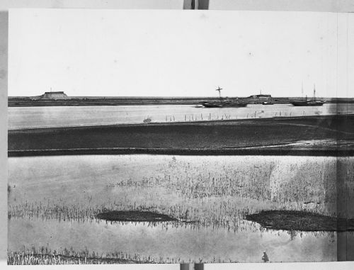
- This photograph is one in a series of views which Felice Beato made of the four Taku Forts (Harris, p. 139; Worswick, p. 138). - This photograph was made from the upper South Taku Fort looking east across the Pei (now Hai) River toward the Gulf of Chihli (now Bo Hai). The British and French combined fleet is visible on the horizon in PH1986:0901:014:002 (Harris, p. 160).
PH1986:0901:014:001
Description:
- This photograph is one in a series of views which Felice Beato made of the four Taku Forts (Harris, p. 139; Worswick, p. 138). - This photograph was made from the upper South Taku Fort looking east across the Pei (now Hai) River toward the Gulf of Chihli (now Bo Hai). The British and French combined fleet is visible on the horizon in PH1986:0901:014:002 (Harris, p. 160).
Personnes et institutions:
Sujet:
architecture, ingénierie, militaire, topographique
architecture, ingénierie, militaire, topographique
Date:
between 22 August and 21 September 1860
between 22 August and 21 September 1860
Titre:
View showing the Pei (now Hai) River delta, with the Lower North Taku Fort (also known as the 2nd North Fort) in the background, Taku (now Dagu), near Tientsin (now Tianjin), China
Actions:
PH1986:0901:014:001
Description:
- This photograph is one in a series of views which Felice Beato made of the four Taku Forts (Harris, p. 139; Worswick, p. 138). - This photograph was made from the upper South Taku Fort looking east across the Pei (now Hai) River toward the Gulf of Chihli (now Bo Hai). The British and French combined fleet is visible on the horizon in PH1986:0901:014:002 (Harris, p. 160).
View showing the Pei (now Hai) River delta, with the Lower North Taku Fort (also known as the 2nd North Fort) in the background, Taku (now Dagu), near Tientsin (now Tianjin), China
Actions:
PH1986:0901:014:001
Description:
- This photograph is one in a series of views which Felice Beato made of the four Taku Forts (Harris, p. 139; Worswick, p. 138). - This photograph was made from the upper South Taku Fort looking east across the Pei (now Hai) River toward the Gulf of Chihli (now Bo Hai). The British and French combined fleet is visible on the horizon in PH1986:0901:014:002 (Harris, p. 160).
Classification:
photographies
photographies
Date:
between 22 August and 21 September 1860
between 22 August and 21 September 1860
Personnes et institutions:
Sujet:
architecture, ingénierie, militaire, topographique
architecture, ingénierie, militaire, topographique


