9774 Results
Form:
archives
Level of archival description:
Fonds
archives
Level of archival description:
Fonds
Actions:
Reference number:
AP052
Synopsis:
The Charbonneau et Charbonneau architectes fonds, 1907-1981, documents the built projects of Québec architectural firm Charbonneau et Charbonneau, architectes. The 145 projects that are represented in this fonds are divided by the works of Audet et Charbonneau, architectes (1913-1917); René Charbonneau, architecte (1918-1945); Charbonneau et Charbonneau, architectes (1945-1969); and Gérard Charbonneau, architecte (1969-1979). Materials in this fonds consist of 3135 drawings (including reprographic copies), 51 textual records and 3 photographs.
People:
Date:
1907-1981
1907-1981
Title:
Charbonneau et Charbonneau architectes fonds
Actions:
AP052
Synopsis:
The Charbonneau et Charbonneau architectes fonds, 1907-1981, documents the built projects of Québec architectural firm Charbonneau et Charbonneau, architectes. The 145 projects that are represented in this fonds are divided by the works of Audet et Charbonneau, architectes (1913-1917); René Charbonneau, architecte (1918-1945); Charbonneau et Charbonneau, architectes (1945-1969); and Gérard Charbonneau, architecte (1969-1979). Materials in this fonds consist of 3135 drawings (including reprographic copies), 51 textual records and 3 photographs.
Form:
archives
Level of archival description:
Fonds
archives
Level of archival description:
Fonds
Date:
1907-1981
1907-1981
People:
Form:
drawings
drawings
Reference number:
ARCH268546
Description:
Contains plans for 12 projects by Abalos & Herreros: - Barcelona Forum 2004, AP164.S1.2000.D9 (Parque Litoral NE; Albergue; La muntaña; Tersa/Edificio de oficinas y planta integral de RSU; Pantalán: 13 colour inkjet prints : details, elevations, plans and sections); - Unidentified project (1 colour inkjet print: site plan); - Plaza y torre Woermann, Las Palmas, AP164.S1.2001.D7 (7 colour inkjet prints, 1 inkjet print: various plans of the tower); - Torres mixtas bioclimáticas en el Humedal de Salburua, Vitoria, AP164.S1.2002.D2 (7 colour inkjet prints: plans, technical information and site plan); - Estudio Gordillo, AP164.S1.1999.D6 (6 colour inkjet prints, 3 inkjet prints: elevations, plans and sections); - New Museum de Arte Contemporáneo, New York, AP164.S1.2003.D1 (9 colour inkjet prints: elevations, plans and sections); - Biblioteca Usera, AP164.S1.1995.D1 (9 inkjet prints, 2 colour inkjet prints); - Planta de reciclaje de residuos urbanos de Valdemingómez, AP164.S1.1996.D4 (10 inkjet prints: elevations, plans and sections); - Centro universitario en Mérida, AP164.S1.1999.D4 (7 inkjet prints: elevations, plans and a section); - Recualificación del espacio público de Ramos, AP164.S1.1997.D7 (4 colour inkjet prints: site plans); - Sala municipal y plaza en Colmenarejo, AP164.S1.1997.D11 (3 inkjet prints: plans); - Planta de biometanización y compostaje de residuos urbanos, Pinto, AP164.S1.2000.D6 (8 colour inkjet prints, 4 inkjet prints: elevations, plans and sections).
People:
Date:
between 1999 and 2006
between 1999 and 2006
Title:
Portfolio with plans related to twelve projects by Abalos & Herreros
Actions:
ARCH268546
Description:
Contains plans for 12 projects by Abalos & Herreros: - Barcelona Forum 2004, AP164.S1.2000.D9 (Parque Litoral NE; Albergue; La muntaña; Tersa/Edificio de oficinas y planta integral de RSU; Pantalán: 13 colour inkjet prints : details, elevations, plans and sections); - Unidentified project (1 colour inkjet print: site plan); - Plaza y torre Woermann, Las Palmas, AP164.S1.2001.D7 (7 colour inkjet prints, 1 inkjet print: various plans of the tower); - Torres mixtas bioclimáticas en el Humedal de Salburua, Vitoria, AP164.S1.2002.D2 (7 colour inkjet prints: plans, technical information and site plan); - Estudio Gordillo, AP164.S1.1999.D6 (6 colour inkjet prints, 3 inkjet prints: elevations, plans and sections); - New Museum de Arte Contemporáneo, New York, AP164.S1.2003.D1 (9 colour inkjet prints: elevations, plans and sections); - Biblioteca Usera, AP164.S1.1995.D1 (9 inkjet prints, 2 colour inkjet prints); - Planta de reciclaje de residuos urbanos de Valdemingómez, AP164.S1.1996.D4 (10 inkjet prints: elevations, plans and sections); - Centro universitario en Mérida, AP164.S1.1999.D4 (7 inkjet prints: elevations, plans and a section); - Recualificación del espacio público de Ramos, AP164.S1.1997.D7 (4 colour inkjet prints: site plans); - Sala municipal y plaza en Colmenarejo, AP164.S1.1997.D11 (3 inkjet prints: plans); - Planta de biometanización y compostaje de residuos urbanos, Pinto, AP164.S1.2000.D6 (8 colour inkjet prints, 4 inkjet prints: elevations, plans and sections).
Form:
drawings
drawings
Date:
between 1999 and 2006
between 1999 and 2006
People:
Actions:
Reference number:
PH1979:0508
Description:
This album depicts photographs, plans, sketches of Stonehenge and texts. Preface is signed by Sir Henry James, 29th May 1867, Southhampton. Album has appendix and List of Books inserted at the end. "Col. Sir Henry James, Director-General of the Ordnance Survey, was a strong believer that photography had to be utilized as a major tool for mapping and survey work and he employed the Royal Engineers for that purpose. Colonel James appears in several of the Stonehenge photographs published by the Ordnance Survey. [...] Stonehenge is the world's most famous, large megalithic stone circle and is usually designated as a site used for religious worship in Neolithic Britain. However, the first use of this locality for documented ritual activity goes back to the Mesolithic and the erection of several large totem poles perhaps as early as 8,000 BC (Stonehenge O). Lunar observations preceded the construction of a causeway c.3200 BC, followed by an earth circle and Heel Stones c.3100 BC (Stonehenge 1a) and the Aubrey Holes (Stonehenge 1b). The Stonehenge site was then abandoned for about 1,000 years when large bluestones quarried in Wales were brought to the site and made into the Double Bluestone Circle with Avenue. 2150 BC (Stonehenge II). Soon thereafter sarsen stones were brought in from Avebury to build the great Sarsen Circle and Trilithon Horseshoe, 2100 BC (Stonehenge IIIz). Bluestones were brought back and added as the Bluestone Circle and Bluestone Horseshoe to the sarsen monument, 1800 BC (Stonehenge IIId). The sacred avenue was extended to the River Avon, 1100 BC (Stonehenge IV), the last phase of megalithic construction at this site. Note that the great stone circle and all construction at the Stonehenge site was completed several hundred years before we can postulate Celtic druids in the vicinity. We can only mention in passing that Stonehenge was embedded within a large ritual complex, where several of the ten megalithic constructions were also monumental in scale. Integration between these structures may not have been well planned in advance, but assuredly was articulated as each was built." Neolithic Britian Online.
People:
Subject:
sculpture, topographic
sculpture, topographic
Date:
1867
1867
Title:
Plans and Photographs of Stonehenge, and of Turusachan in the Island of Lewis; with Notes Relating to the Druids and Sketches of Cromlechs in Ireland
Actions:
PH1979:0508
Description:
This album depicts photographs, plans, sketches of Stonehenge and texts. Preface is signed by Sir Henry James, 29th May 1867, Southhampton. Album has appendix and List of Books inserted at the end. "Col. Sir Henry James, Director-General of the Ordnance Survey, was a strong believer that photography had to be utilized as a major tool for mapping and survey work and he employed the Royal Engineers for that purpose. Colonel James appears in several of the Stonehenge photographs published by the Ordnance Survey. [...] Stonehenge is the world's most famous, large megalithic stone circle and is usually designated as a site used for religious worship in Neolithic Britain. However, the first use of this locality for documented ritual activity goes back to the Mesolithic and the erection of several large totem poles perhaps as early as 8,000 BC (Stonehenge O). Lunar observations preceded the construction of a causeway c.3200 BC, followed by an earth circle and Heel Stones c.3100 BC (Stonehenge 1a) and the Aubrey Holes (Stonehenge 1b). The Stonehenge site was then abandoned for about 1,000 years when large bluestones quarried in Wales were brought to the site and made into the Double Bluestone Circle with Avenue. 2150 BC (Stonehenge II). Soon thereafter sarsen stones were brought in from Avebury to build the great Sarsen Circle and Trilithon Horseshoe, 2100 BC (Stonehenge IIIz). Bluestones were brought back and added as the Bluestone Circle and Bluestone Horseshoe to the sarsen monument, 1800 BC (Stonehenge IIId). The sacred avenue was extended to the River Avon, 1100 BC (Stonehenge IV), the last phase of megalithic construction at this site. Note that the great stone circle and all construction at the Stonehenge site was completed several hundred years before we can postulate Celtic druids in the vicinity. We can only mention in passing that Stonehenge was embedded within a large ritual complex, where several of the ten megalithic constructions were also monumental in scale. Integration between these structures may not have been well planned in advance, but assuredly was articulated as each was built." Neolithic Britian Online.
Date:
1867
1867
People:
Subject:
sculpture, topographic
sculpture, topographic
Form:
drawings
drawings

Actions:
Reference number:
DR1987:0400
Description:
- These sketches are mostly drawings for runway designs within the square site plan of the Los Angeles Municipal Airport project, with an elevation showing the massing of forms for the airport buildings. There are also at least three sketches for a segmentally-arched structure, possibly elevations for Lloyd Wright's second project for a shell for the Hollywood Bowl. This second project was commissioned in 1928; it was to be an elliptical shell, quarter-circular in elevation.
People:
Subject:
architecture
architecture
Date:
1929
1929
Title:
Los Angeles Municipal Airport: Thumbnail site plans, conceptual elevations and perspectives with some elevations, possibly for the Hollywood Bowl shell
Actions:
DR1987:0400
Description:
- These sketches are mostly drawings for runway designs within the square site plan of the Los Angeles Municipal Airport project, with an elevation showing the massing of forms for the airport buildings. There are also at least three sketches for a segmentally-arched structure, possibly elevations for Lloyd Wright's second project for a shell for the Hollywood Bowl. This second project was commissioned in 1928; it was to be an elliptical shell, quarter-circular in elevation.
Form:
drawings
drawings
Date:
1929
1929
People:
Subject:
architecture
architecture
Form:
models
models
Actions:
Reference number:
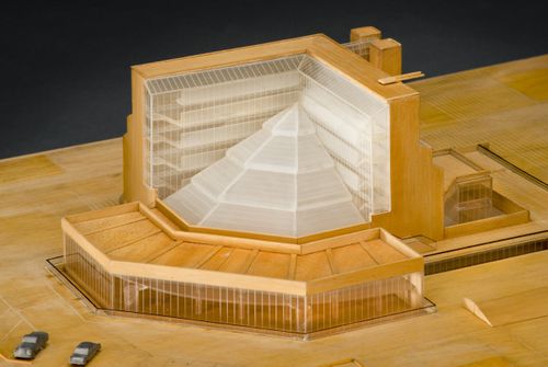
AP140.S2.SS1.D26.P30.1
Description:
model shows the site and immediate surroundings of the History Faculty Building, and interior elements including the library mezzanine and the galleries and escape stairs of the L-shaped block; the model was part of the 1963 competition entry, and shows the library roof oriented towards the south-west, rather than towards the south-east, as in the executed design; also shows a different design for the terrace to the north, and for the stairs flanking the brick end walls
People:
Date:
1963
1963
Title:
History Faculty Building, University of Cambridge, Cambridge, England: presentation model
Actions:
AP140.S2.SS1.D26.P30.1
Description:
model shows the site and immediate surroundings of the History Faculty Building, and interior elements including the library mezzanine and the galleries and escape stairs of the L-shaped block; the model was part of the 1963 competition entry, and shows the library roof oriented towards the south-west, rather than towards the south-east, as in the executed design; also shows a different design for the terrace to the north, and for the stairs flanking the brick end walls
Form:
models
models
Date:
1963
1963
People:
Level of archival description:
Project
Project
Title:
9A Windsor, Worthing
9A Windsor, Worthing
Reference number:
AP144.S2.D32
Description:
File documents an executed project for a garden pavilion and pool in Worthing, West Sussex, England, for the two children of Mr and Mrs T. L. Blau. The design includes "anti-adult" elements such as the pavilion's low ceiling and a steep, open stair leading to an upper deck. The children assisted with the construction and were given notes concerning the pavilion's long-term maintenance. Untreated cedar boards were used for the pavilion's exterior due to the site's close proximity to the sea. In addition to working drawings, the file contains a site plan of existing conditions, design development sketches of alternative layouts for pavilion, pool and deck areas. Material in this file was produced between 1962 and 1975, but predominantly 1962. File contains working drawings, photographic material, and textual records.
People:
Date:
1962-1975, predominant 1962
1962-1975, predominant 1962
Title:
9A Windsor, Worthing
Actions:
AP144.S2.D32
Description:
File documents an executed project for a garden pavilion and pool in Worthing, West Sussex, England, for the two children of Mr and Mrs T. L. Blau. The design includes "anti-adult" elements such as the pavilion's low ceiling and a steep, open stair leading to an upper deck. The children assisted with the construction and were given notes concerning the pavilion's long-term maintenance. Untreated cedar boards were used for the pavilion's exterior due to the site's close proximity to the sea. In addition to working drawings, the file contains a site plan of existing conditions, design development sketches of alternative layouts for pavilion, pool and deck areas. Material in this file was produced between 1962 and 1975, but predominantly 1962. File contains working drawings, photographic material, and textual records.
Level of archival description:
File 32
File 32
Date:
1962-1975, predominant 1962
1962-1975, predominant 1962
People:
Level of archival description:
Project
Project
Actions:
Reference number:
AP018.S1.1970.PR10
Description:
This project series documents an expansion to an office building at the Toronto International Airport in Mississauga, Ontario in 1970. The office identified the project number as 70060. During this time, John B. Parkin Associates, and later John C. Parkin's new firm Parkin Architects Planners, were commissioned by the government Department of Transport Air Services to complete more than a dozen projects at the Toronto International Airport, including terminals one and two. This project consisted of an expansion of the existing offices attached to cargo block B warehouse. The warehouse was also undergoing expansion at this time (see project series AP018.S1.1970.PR05 described in this fonds). The project is recorded through reprographic copies of drawings dating from 1970, which include site and floor plans, sections, elevations and electrical and mechanical drawings.
People:
Date:
1970
1970
Title:
Office Expansion Block B, Toronto International Airport, Mississauga, Ontario (1970)
Actions:
AP018.S1.1970.PR10
Description:
This project series documents an expansion to an office building at the Toronto International Airport in Mississauga, Ontario in 1970. The office identified the project number as 70060. During this time, John B. Parkin Associates, and later John C. Parkin's new firm Parkin Architects Planners, were commissioned by the government Department of Transport Air Services to complete more than a dozen projects at the Toronto International Airport, including terminals one and two. This project consisted of an expansion of the existing offices attached to cargo block B warehouse. The warehouse was also undergoing expansion at this time (see project series AP018.S1.1970.PR05 described in this fonds). The project is recorded through reprographic copies of drawings dating from 1970, which include site and floor plans, sections, elevations and electrical and mechanical drawings.
Level of archival description:
Project
Project
Date:
1970
1970
People:
Level of archival description:
Project
Project
Actions:
Reference number:
AP206.S1.1985.PR07
Description:
This project series documents a housing study for Dr. Bhimrao Ambedker University in Lucknow, India around 1985. This project consisted of multi-storey buildings arranged in clusters. The buildings had three apartments on each floor and were joined to create common courtyards. Diamond shaped buildings with centre courtyards were also investigated for a different area of the campus, as well as a nursery school, shopping complex, administrative block and information tower. The architect also made recommendations to build facilities near the campus for recycling, waste water, vegetables and livestock, stating that doing so would avoid the natural occurrence of slums that served a similar purpose. The project is recorded through original drawings of site, floor and landscaping plans, as well as elevations and photographic negatives of the project model, likely dating from around 1985.
People:
Date:
circa 1985
circa 1985
Title:
Dr. Bhimrao Ambedker University, housing study, Lucknow, India (circa 1985)
Actions:
AP206.S1.1985.PR07
Description:
This project series documents a housing study for Dr. Bhimrao Ambedker University in Lucknow, India around 1985. This project consisted of multi-storey buildings arranged in clusters. The buildings had three apartments on each floor and were joined to create common courtyards. Diamond shaped buildings with centre courtyards were also investigated for a different area of the campus, as well as a nursery school, shopping complex, administrative block and information tower. The architect also made recommendations to build facilities near the campus for recycling, waste water, vegetables and livestock, stating that doing so would avoid the natural occurrence of slums that served a similar purpose. The project is recorded through original drawings of site, floor and landscaping plans, as well as elevations and photographic negatives of the project model, likely dating from around 1985.
Level of archival description:
Project
Project
Date:
circa 1985
circa 1985
People:
Level of archival description:
Project
Project
Reference number:
AP178.S1.1980.PR05
Description:
This project series documents the Monte Picoto hotel and restaurant in Braga, Portugal. While the records were held in the office's archives, this project was assigned the number 6/80. The office assigned the date 1981 to this project. Proposed as a hotel and restaurant, this project was designed for a competition on the most fitting real estate for Monte Picoto. Competitors had leeway to decide on the function and form of the real estate. The competition was administered by the entrepreneur José Veloso Braque and promoted by the City Council. A winner for the competition was never declared and the project was not built. Documenting this project are documents about the competition from the Camara Municipal de Braga, photographs, elevations, studies for the project site, and sketches of the proposed hotel and restaurant.
People:
Date:
1980-1982
1980-1982
Title:
Monte Picoto [Monte Picoto hotel and restaurant], Braga, Portugal (1981)
Actions:
AP178.S1.1980.PR05
Description:
This project series documents the Monte Picoto hotel and restaurant in Braga, Portugal. While the records were held in the office's archives, this project was assigned the number 6/80. The office assigned the date 1981 to this project. Proposed as a hotel and restaurant, this project was designed for a competition on the most fitting real estate for Monte Picoto. Competitors had leeway to decide on the function and form of the real estate. The competition was administered by the entrepreneur José Veloso Braque and promoted by the City Council. A winner for the competition was never declared and the project was not built. Documenting this project are documents about the competition from the Camara Municipal de Braga, photographs, elevations, studies for the project site, and sketches of the proposed hotel and restaurant.
Level of archival description:
Project
Project
Date:
1980-1982
1980-1982
People:
Level of archival description:
Project
Project
Actions:
Reference number:
CI005.S1.1922.PR1
Description:
The city of Rotterdam in May 1922 commissioned a project to re-house homeless slum-dwellers and to alleviate Rotterdam's crisis in housing shortage: the housing unit was known as The Witte Dorp housing community, in the polder of Oud-Mathenesse. Oud designed the site plan and dwellings for this municipal housing project of 343 dwellings, eight shop units and a fire-engine shed. Oud created a geometric street plan with short axes that joined at the playground and townscape with identical facades of row houses facing one another. The houses were white with contrasting red roofs, blue front doors and yellow door frames and window casings (Taverne et al. 2001, 250). Project series includes drawings of plans and eighteen photographs, including exterior views and photographs of a plan.
People:
Date:
1922-1924
1922-1924
Title:
Oud-Mathenesse Municipal Housing Scheme, Rotterdam, Netherlands (1922-1924)
Actions:
CI005.S1.1922.PR1
Description:
The city of Rotterdam in May 1922 commissioned a project to re-house homeless slum-dwellers and to alleviate Rotterdam's crisis in housing shortage: the housing unit was known as The Witte Dorp housing community, in the polder of Oud-Mathenesse. Oud designed the site plan and dwellings for this municipal housing project of 343 dwellings, eight shop units and a fire-engine shed. Oud created a geometric street plan with short axes that joined at the playground and townscape with identical facades of row houses facing one another. The houses were white with contrasting red roofs, blue front doors and yellow door frames and window casings (Taverne et al. 2001, 250). Project series includes drawings of plans and eighteen photographs, including exterior views and photographs of a plan.
Level of archival description:
project
project
Date:
1922-1924
1922-1924
People: