458 Résultats
Niveau de description archivistique:
Série(s)
Série(s)
Numéro de référence:
AP175.S1
Description:
Series 1, Erasmus Bridge, Rotterdam, Netherlands, 1990-1996, documents the design, conception and construction of a third bridge for Rotterdam over the Nieuwe Maas River. The bridge connects the Kop van Zuid neighborhood, located on the south side of the river, to Willemsplein, located on the north side. The bridge is considered as a landmark in Rotterdam’s landscape. The Erasmus Bridge was a formative project in the thinking of UNStudio. It was originally supposed to be designed by architect Maarten Struijs who was the city of Rotterdam principal architect and who is responsible for the concept of the neighboring Willem Bridge. Ben van Berkel came later into the project and was hired as a designing consultant along with architect Wim Quist. Ben van Berkel proposed design was selected allowing him and his firm, which was called Van Berkel & Bos Architectuurbureau at that time, to supervise the conception and construction of the project, from the original concept to piers design to the selection of every item of bridge furniture such as traffic lights, bridge camera and handrails. The bridge was designed to fit the distinct character and industrial past of Rotterdam. The construction of this landmark was one component of a larger redevelopment project, coinciding with other major developments in the city of Rotterdam. The goal was to develop a dense urban intervention on the southern shore of the Nieuwe Maas, in the Kop van Zuid neighborhood. This explains the implication of UNStudio in the planning of urban configuration of the neighborhoods on both sides of the river and their work for Spido, a ferry company operating on the Nieuwe Maas, work spaces and parking garage. This commercial building was designed by the firm and also hosts The Grand Café and Jazz Café. This commercial building is integrated to one of the bridge pillar on the north shore of the river. For the design the firm used AutoCAD to work along with engineers and to conceptualize 3D models. They also used the software to evaluate the circulation flow of drivers, pedestrians and streetcars, measuring its impact on the structure and the urban configuration of the neighborhoods on both sides of the river. The records contain sketches for bridge and pier design, plans and sections for pier, Spido and bridge, architectural and construction details created by engineering companies for every component of the bridge, from drawbridge, to cable car system, to bridge furnitures such as traffic light, handrails and cameras and photographs documenting the research for precedent and the original configuration of the neighborhoods on both sides of the river. The record contains AutoCAD plans, details and sections for both the bridge and Spido parking garage. The records also contain one physical model: a small scale plastic, glass and metal model of the bridge.
Personnes et institutions:
Date:
1990-1996
1990-1996
Titre:
Erasmus Bridge, Rotterdam, Netherlands, 1990-1996
Actions:
AP175.S1
Description:
Series 1, Erasmus Bridge, Rotterdam, Netherlands, 1990-1996, documents the design, conception and construction of a third bridge for Rotterdam over the Nieuwe Maas River. The bridge connects the Kop van Zuid neighborhood, located on the south side of the river, to Willemsplein, located on the north side. The bridge is considered as a landmark in Rotterdam’s landscape. The Erasmus Bridge was a formative project in the thinking of UNStudio. It was originally supposed to be designed by architect Maarten Struijs who was the city of Rotterdam principal architect and who is responsible for the concept of the neighboring Willem Bridge. Ben van Berkel came later into the project and was hired as a designing consultant along with architect Wim Quist. Ben van Berkel proposed design was selected allowing him and his firm, which was called Van Berkel & Bos Architectuurbureau at that time, to supervise the conception and construction of the project, from the original concept to piers design to the selection of every item of bridge furniture such as traffic lights, bridge camera and handrails. The bridge was designed to fit the distinct character and industrial past of Rotterdam. The construction of this landmark was one component of a larger redevelopment project, coinciding with other major developments in the city of Rotterdam. The goal was to develop a dense urban intervention on the southern shore of the Nieuwe Maas, in the Kop van Zuid neighborhood. This explains the implication of UNStudio in the planning of urban configuration of the neighborhoods on both sides of the river and their work for Spido, a ferry company operating on the Nieuwe Maas, work spaces and parking garage. This commercial building was designed by the firm and also hosts The Grand Café and Jazz Café. This commercial building is integrated to one of the bridge pillar on the north shore of the river. For the design the firm used AutoCAD to work along with engineers and to conceptualize 3D models. They also used the software to evaluate the circulation flow of drivers, pedestrians and streetcars, measuring its impact on the structure and the urban configuration of the neighborhoods on both sides of the river. The records contain sketches for bridge and pier design, plans and sections for pier, Spido and bridge, architectural and construction details created by engineering companies for every component of the bridge, from drawbridge, to cable car system, to bridge furnitures such as traffic light, handrails and cameras and photographs documenting the research for precedent and the original configuration of the neighborhoods on both sides of the river. The record contains AutoCAD plans, details and sections for both the bridge and Spido parking garage. The records also contain one physical model: a small scale plastic, glass and metal model of the bridge.
Niveau de description archivistique:
Series
Series
Date:
1990-1996
1990-1996
Personnes et institutions:
Niveau de description archivistique:
Projet
Projet
Numéro de référence:
AP075.S1.1994.PR01
Description:
Project series documents Cornelia Hahn Oberlander's project of a roof garden for the New Canadian Embassy at Leipziger Platz in Berlin, Germany. Oberlander worked on this project in from 1999-2005 with architectural firm Kuwabara, Payne, McKenna, Blumberg Architects. Oberlander's work for the project included a terrace at the Ambassador's Level (6th floor) with mounded evergreen white flowering groundcover azaleas, cascading roses hanging along the Leipzigerstrasse facade, and a green roof on top of the building. The concept of the landscaping of the green roof was to represente Canada's land of the north in an abstract form, simulating the river system of the MacKenzie River in the Northwest Territories, linking Alberta to the Arctic Ocean. She used black-glass panels to represente the water. The drainage for the green roof was also connected the drainage infrastructure of the building to recycle the water collected from the roof. The project series includes sketches and design development drawings for the green roof landscaping, planting details and irrigation details, presentation drawings from KPMB and drawings of the building used as reference. The project is also documented through research material, concept notes by Oberlander, correspondence, including with architects, consultants, contractors and clients, proposal, specifications, and press clippings about the project. The project series also includes sample of glass tiles used for the landscaping.
Personnes et institutions:
Date:
1994-2005
1994-2005
Titre:
New Canadian Embassy in Berlin, Germany (1994-2005)
Actions:
AP075.S1.1994.PR01
Description:
Project series documents Cornelia Hahn Oberlander's project of a roof garden for the New Canadian Embassy at Leipziger Platz in Berlin, Germany. Oberlander worked on this project in from 1999-2005 with architectural firm Kuwabara, Payne, McKenna, Blumberg Architects. Oberlander's work for the project included a terrace at the Ambassador's Level (6th floor) with mounded evergreen white flowering groundcover azaleas, cascading roses hanging along the Leipzigerstrasse facade, and a green roof on top of the building. The concept of the landscaping of the green roof was to represente Canada's land of the north in an abstract form, simulating the river system of the MacKenzie River in the Northwest Territories, linking Alberta to the Arctic Ocean. She used black-glass panels to represente the water. The drainage for the green roof was also connected the drainage infrastructure of the building to recycle the water collected from the roof. The project series includes sketches and design development drawings for the green roof landscaping, planting details and irrigation details, presentation drawings from KPMB and drawings of the building used as reference. The project is also documented through research material, concept notes by Oberlander, correspondence, including with architects, consultants, contractors and clients, proposal, specifications, and press clippings about the project. The project series also includes sample of glass tiles used for the landscaping.
Niveau de description archivistique:
Project
Project
Date:
1994-2005
1994-2005
Personnes et institutions:
Niveau de description archivistique:
Projet
Projet
Numéro de référence:
AP018.S1.1964.PR07
Description:
This project series documents the Donwood Foundations Hospital and Rehabilitation Centre in North York, Ontario from 1964-1966. The office identified the project number as 6418. This project consisted of a four level building, with brick and steel fascia exteriors, that served as an alcohol and addiction treatment hospital. Surrounded by wooded landscapes and overlooking the Don River and ravine, the L-shaped building was 42,000 square feet in size. The building's interiors were designed to exude warmth, friendship and inclusion through the use of warm wood finishes and colourful carpeting and upholstery. The hospital included 49 patient beds, an auditorium, a lounge with balcony, and therapy rooms. The project is recorded through a presentation board of an exterior photograph and reprographic copies of drawings dating from 1966. The drawings consist of construction plans, elevations, sections, details, layouts, and structural, mechanical and electrical drawings.
Personnes et institutions:
Date:
1966
1966
Titre:
Donwood Foundation Hospital and Rehabilitation Centre, North York, Ontario (1964-1966)
Actions:
AP018.S1.1964.PR07
Description:
This project series documents the Donwood Foundations Hospital and Rehabilitation Centre in North York, Ontario from 1964-1966. The office identified the project number as 6418. This project consisted of a four level building, with brick and steel fascia exteriors, that served as an alcohol and addiction treatment hospital. Surrounded by wooded landscapes and overlooking the Don River and ravine, the L-shaped building was 42,000 square feet in size. The building's interiors were designed to exude warmth, friendship and inclusion through the use of warm wood finishes and colourful carpeting and upholstery. The hospital included 49 patient beds, an auditorium, a lounge with balcony, and therapy rooms. The project is recorded through a presentation board of an exterior photograph and reprographic copies of drawings dating from 1966. The drawings consist of construction plans, elevations, sections, details, layouts, and structural, mechanical and electrical drawings.
Niveau de description archivistique:
Project
Project
Date:
1966
1966
Personnes et institutions:
Niveau de description archivistique:
Projet
Projet
Numéro de référence:
AP178.S1.1983.PR08
Description:
This project series documents the Plano de Expansão da Cidade de Macau (Areia P. e Porto E.) in Macau, China. While the records were held in the office’s archives this project was assigned the number 16/80. The office assigned the date 1982 to this project. Macau is a Chinese-Portuguese peninsula near the Pear River Delta on the south coast of China. After 1950, the speedy industrial growth caused massive waves of immigration and created housing problems. Macau's governement wanted to reorganize the urban landscape in order to readapt the territory to the economic and political realities. Siza was hired by the P&T Group as part of a team of specialist-consultants to rethink the districts of Areia Preta and Porto Exterior. A first proposal was submitted in 1984. The proposed plans were accepted by the authorities years later, but never realized due to the construction of hotels and casinos instead of housing. Documenting this project are studies, plans and project site plans. Textual materials include project documentation and correspondence. Photographic materials document the models and project site. These materials date from 1981-2012.
Personnes et institutions:
Date:
1981-2012
1981-2012
Titre:
Plano de Expansão da Cidade de Macau (Areia P. e Porto E.) [Macau City expansion plan], Macau, China (1982)
Actions:
AP178.S1.1983.PR08
Description:
This project series documents the Plano de Expansão da Cidade de Macau (Areia P. e Porto E.) in Macau, China. While the records were held in the office’s archives this project was assigned the number 16/80. The office assigned the date 1982 to this project. Macau is a Chinese-Portuguese peninsula near the Pear River Delta on the south coast of China. After 1950, the speedy industrial growth caused massive waves of immigration and created housing problems. Macau's governement wanted to reorganize the urban landscape in order to readapt the territory to the economic and political realities. Siza was hired by the P&T Group as part of a team of specialist-consultants to rethink the districts of Areia Preta and Porto Exterior. A first proposal was submitted in 1984. The proposed plans were accepted by the authorities years later, but never realized due to the construction of hotels and casinos instead of housing. Documenting this project are studies, plans and project site plans. Textual materials include project documentation and correspondence. Photographic materials document the models and project site. These materials date from 1981-2012.
Niveau de description archivistique:
Project
Project
Date:
1981-2012
1981-2012
Personnes et institutions:
Classification:
événements
événements
Actions:
Description:
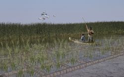
La bande indienne de St. Peter’s (désormais connue sous le nom de la Première Nation de Peguis) a été évacuée de force de son territoire d’origine, situé aux abords du marais Netley-Libau, à partir de 1908, à la suite d’un vote de cession illégal. Depuis, la santé de la région, autrefois patrie des Peguis, a décliné en raison d’impitoyables inondations et embâcles(...)
La bande indienne de St. Peter’s (désormais connue sous le nom de la Première Nation de Peguis) a été évacuée de force de son territoire d’origine, situé aux abords du marais Netley-Libau, à partir de 1908, à la suite d’un vote de cession illégal. Depuis, la santé de la région, autrefois patrie des Peguis, a décliné en raison d’impitoyables inondations et embâcles(...)
Localisation:
en ligne Mot(s)-clé(s):
Design mené par des Autochtones, boursière, Première Nation Peguis, réhabilitation des terres
en ligne Mot(s)-clé(s):
Design mené par des Autochtones, boursière, Première Nation Peguis, réhabilitation des terres
Date:
27 avril 2023, 18h à 19h30
27 avril 2023, 18h à 19h30
Titre:
La Première Nation de Peguis et le marais Netley-Libau : documenter l’utilisation et l’occupation des territoires autochtones à l’embouchure du lac Winnipeg
Actions:
Description:
La bande indienne de St. Peter’s (désormais connue sous le nom de la Première Nation de Peguis) a été évacuée de force de son territoire d’origine, situé aux abords du marais Netley-Libau, à partir de 1908, à la suite d’un vote de cession illégal. Depuis, la santé de la région, autrefois patrie des Peguis, a décliné en raison d’impitoyables inondations et embâcles(...)
Classification:
événements
événements
Date:
27 avril 2023
18h à 19h30
27 avril 2023
18h à 19h30
Localisation:
en ligne Mot(s)-clé(s):
Design mené par des Autochtones, boursière, Première Nation Peguis, réhabilitation des terres
en ligne Mot(s)-clé(s):
Design mené par des Autochtones, boursière, Première Nation Peguis, réhabilitation des terres
Niveau de description archivistique:
Projet
Projet
Numéro de référence:
AP164.S1.2003.D10
Description:
The project series documents the commission and built project for an urban development and a public park on the banks of the rivers Torio and Bernesca in the area of La Lastra, León, Spain. The firm identified the project as number 173. “The park of La Lastra is composed by the superpositioning [sic] of four different states of natural space: a fluvial park, an urban park, an agricultural park and a park with common installations. Being next to the urbanization of La Lastra, both public spaces, both adopt a minimum strategy of landscape bubbles and urbanized bubbles respectively in the way that the whole complex becomes a continuum and achieves a scale able to diffuse the traditional limits of either urban fabric or park, confirming a singular complex which responds to the way in which new generations can understand the relation between nature and artificial.” (ARCH270975) Two other projects are related to this one: Alcorque para León (AP164.S1.2004.D5) and Puentes de León (AP164.S1.2004.D6). Documenting the project are presentation documents, notes, a dummy and a proposal.
Personnes et institutions:
Date:
circa 2003-2004
circa 2003-2004
Titre:
Urbanización del sector La Lastra, León, Spain (2003)
Actions:
AP164.S1.2003.D10
Description:
The project series documents the commission and built project for an urban development and a public park on the banks of the rivers Torio and Bernesca in the area of La Lastra, León, Spain. The firm identified the project as number 173. “The park of La Lastra is composed by the superpositioning [sic] of four different states of natural space: a fluvial park, an urban park, an agricultural park and a park with common installations. Being next to the urbanization of La Lastra, both public spaces, both adopt a minimum strategy of landscape bubbles and urbanized bubbles respectively in the way that the whole complex becomes a continuum and achieves a scale able to diffuse the traditional limits of either urban fabric or park, confirming a singular complex which responds to the way in which new generations can understand the relation between nature and artificial.” (ARCH270975) Two other projects are related to this one: Alcorque para León (AP164.S1.2004.D5) and Puentes de León (AP164.S1.2004.D6). Documenting the project are presentation documents, notes, a dummy and a proposal.
Niveau de description archivistique:
Project
Project
Date:
circa 2003-2004
circa 2003-2004
Personnes et institutions:
Niveau de description archivistique:
Projet
Projet
Titre:
Weavers' Studio
Weavers' Studio
Numéro de référence:
AP182.S1.2013.D2
Description:
File documents a project for a live-work complex in Dehradun, Uttarakhand, India. Commissioned by Chiaki Maki, a Japanese textile weaver who spends a portion of each year in northern India, this complex in the Himalayan foothills provides working space for a studio of twenty-five weavers from all over the country. It is conceived as a cyclical, self-sufficient farm system that integrates all aspects of the weaving process, from cultivating indigo and henna for dye to gathering silk from cocoons and spinning wool. The site had been previously cultivated, and the design works with the landscape's existing pathways, terraces, and mango groves. Nearly all construction materials--including the brick, limestone, and phosphorescent river stones used in the foundation and to treat the brick walls--come from within a two-kilometre radius of the studio. The five-sided building occupying the centre of the site is the workshop itself, which frames a courtyard for gatherings (of weavers, children, etc.). A gallery in the complex displays the weavers' work, while the linear buildings accommodate motorcycle parking, a guest house, and residences for Maki and her partner as well as the site caretaker and his family. File contains artefacts and realia, models, photographs, drawings, site reports, and a video recording.
Personnes et institutions:
Date:
2012-2015
2012-2015
Titre:
Weavers' Studio
Actions:
AP182.S1.2013.D2
Description:
File documents a project for a live-work complex in Dehradun, Uttarakhand, India. Commissioned by Chiaki Maki, a Japanese textile weaver who spends a portion of each year in northern India, this complex in the Himalayan foothills provides working space for a studio of twenty-five weavers from all over the country. It is conceived as a cyclical, self-sufficient farm system that integrates all aspects of the weaving process, from cultivating indigo and henna for dye to gathering silk from cocoons and spinning wool. The site had been previously cultivated, and the design works with the landscape's existing pathways, terraces, and mango groves. Nearly all construction materials--including the brick, limestone, and phosphorescent river stones used in the foundation and to treat the brick walls--come from within a two-kilometre radius of the studio. The five-sided building occupying the centre of the site is the workshop itself, which frames a courtyard for gatherings (of weavers, children, etc.). A gallery in the complex displays the weavers' work, while the linear buildings accommodate motorcycle parking, a guest house, and residences for Maki and her partner as well as the site caretaker and his family. File contains artefacts and realia, models, photographs, drawings, site reports, and a video recording.
Niveau de description archivistique:
Project
Project
Date:
2012-2015
2012-2015
Personnes et institutions:
Niveau de description archivistique:
Série(s)
Série(s)
Titre:
Dessins et tableaux
Dessins et tableaux
Numéro de référence:
AP104.S1
Description:
Series I consists of sketches, drawings and paintings, mostly created by Parizeau. From the period he spent in Europe (1923-1933), there are 11 student drawings in the standard presentation format of the École des Beaux-arts de Paris, a volume of course notes, as well as unidentified drawings, sketchbooks and paintings of primarily buildings and landscapes executed in Paris and during his travels in France. Drawings relating to Parizeau's architectural career in Montreal are represented in a number of independant projects, including a small chapel beside the St. Lawrence River, a pair of two-storey cabin-cottages outside of Montreal, and several residences in the city. The documents are mostly original preliminary studies with some reproductions of working drawings. It should be noted that there are also photographs of exterior details of the Laroque Residence and the Jarry Residence in documents CO2 in Series II. Reproductions of designs for worker housing by French architect Eugène Beaudoin in 1938 perhaps give a clue to Parizeau's relatively early employment of modernist forms. A residence in Baie D'Urfé is unlikely to be connected to Parizeau because its date, ca. 1955, is a decade after his death. Parizeau's concern with furniture and interior design is represented in the Archive with many lively perspective sketches in colour, and elevation and plan studies of several kinds of rooms and types of furniture. Some preliminary drawings for interiors were grouped with the Gillow house in Ville Mont-Royal, and the Walter Downs Residence in Montreal. The artworks by Parizeau consist of paintings and drawings of landscapes, buildings, still lifes and figure studies on loose sheets and in bound sketchbooks. These works are executed in a variety of media, including pencil, coloured pencil, watercolour on paper, and oil paint on masonite panels. Studies of buildings in Brittany and Paris are the subjects in three small sketchbooks, while larger spiral-bound drawing books contain some architectural plans, elevations and details. Most of these artworks and sketches were likely created in Europe before 1933.
Personnes et institutions:
Date:
1917-1955
1917-1955
Titre:
Dessins et tableaux
Actions:
AP104.S1
Description:
Series I consists of sketches, drawings and paintings, mostly created by Parizeau. From the period he spent in Europe (1923-1933), there are 11 student drawings in the standard presentation format of the École des Beaux-arts de Paris, a volume of course notes, as well as unidentified drawings, sketchbooks and paintings of primarily buildings and landscapes executed in Paris and during his travels in France. Drawings relating to Parizeau's architectural career in Montreal are represented in a number of independant projects, including a small chapel beside the St. Lawrence River, a pair of two-storey cabin-cottages outside of Montreal, and several residences in the city. The documents are mostly original preliminary studies with some reproductions of working drawings. It should be noted that there are also photographs of exterior details of the Laroque Residence and the Jarry Residence in documents CO2 in Series II. Reproductions of designs for worker housing by French architect Eugène Beaudoin in 1938 perhaps give a clue to Parizeau's relatively early employment of modernist forms. A residence in Baie D'Urfé is unlikely to be connected to Parizeau because its date, ca. 1955, is a decade after his death. Parizeau's concern with furniture and interior design is represented in the Archive with many lively perspective sketches in colour, and elevation and plan studies of several kinds of rooms and types of furniture. Some preliminary drawings for interiors were grouped with the Gillow house in Ville Mont-Royal, and the Walter Downs Residence in Montreal. The artworks by Parizeau consist of paintings and drawings of landscapes, buildings, still lifes and figure studies on loose sheets and in bound sketchbooks. These works are executed in a variety of media, including pencil, coloured pencil, watercolour on paper, and oil paint on masonite panels. Studies of buildings in Brittany and Paris are the subjects in three small sketchbooks, while larger spiral-bound drawing books contain some architectural plans, elevations and details. Most of these artworks and sketches were likely created in Europe before 1933.
Niveau de description archivistique:
Série 1
Série 1
Date:
1917-1955
1917-1955
Personnes et institutions:
Classification:
archives
Niveau de description archivistique:
Fonds
archives
Niveau de description archivistique:
Fonds
Titre:
Fonds Marcel Parizeau
Fonds Marcel Parizeau
Numéro de référence:
AP104
Résumé:
Le Fonds Marcel Parizeau contient des documents relatifs à la formation et à la vie de professionnel de Marcel Parizeau. Il contient aussi des œuvres d'art réalisées par ce dernier. Le fonds est composé de dessins d'architecture et de meubles, de carnets de croquis, de tableaux, de manuscrits, de correspondances, ainsi que quelques autres documents.
Personnes et institutions:
Date:
1917-1955
1917-1955
Titre:
Fonds Marcel Parizeau
Actions:
AP104
Résumé:
Le Fonds Marcel Parizeau contient des documents relatifs à la formation et à la vie de professionnel de Marcel Parizeau. Il contient aussi des œuvres d'art réalisées par ce dernier. Le fonds est composé de dessins d'architecture et de meubles, de carnets de croquis, de tableaux, de manuscrits, de correspondances, ainsi que quelques autres documents.
Classification:
archives
Niveau de description archivistique:
Fonds
archives
Niveau de description archivistique:
Fonds
Date:
1917-1955
1917-1955
Personnes et institutions:
Niveau de description archivistique:
Projet
Projet
Numéro de référence:
AP018.S1.1972.PR18
Description:
This project series documents the design and construction of a library and an addition to city hall in Fredericton, New Brunswick from 1972-1975. The office identified the project number as 7226. This project consisted of two distinct parts; a public library constructed at the corners of Campbell and Carleton Streets, and an addition to city hall whose original building was constructed at the corners of Queen and York Streets around 1875. These two buildings were located two blocks from one another, but a master plan for the project shows that the separating streets would be removed in favour of a pedestrian friendly landscape. Both buildings were located next to the St. John River. For this project, Parkin Architects Planners partnered with architectural firm Graham Napier Associates to form the joint venture referred to as Graham Parkin Architects Engineers Planners. The brick-clad addition to city hall nearly doubled the square footage of the ground and first floors. The original city hall was four levels and the addition was two, with a mechanical penthouse on top. The new areas included departmental offices such as planning, engineering and sewage, a drafting room, conference room, and reception, among others. The library consisted of a two-storey, brick-clad building that was approximately 24,000 square feet in size with a 16 car parking lot. The ground floor included reception and exhibit areas, stacks, administration offices, bookmobiles, and staff lockers, while the second level had stacks and reading areas, audiovisual areas and a staff work room and break room. The library also had a mechanical penthouse on top. The project is recorded through drawings, including mounted presentation boards, photographic materials and textual records dating from 1972-1978. The drawings consist of original sketches, plans, sections, elevations and details of both city hall and the library, and some drawings used for construction. There are also drawings of the original city hall, first drafted around 1875. The photographs show existing buildings and the construction progress of the project. The textual records consist of correspondence, conference reports, interoffice letters, specifications, consultancy documentation, a soil investigation, research and drawing transmittal records. File AP018.S1.1972.PR18.020 contains an index to the textual materials, which was created by the office.
Personnes et institutions:
Date:
circa 1972-1978
circa 1972-1978
Titre:
City Hall and Library Facilities, Fredericton, New Brunswick (1972-1975)
Actions:
AP018.S1.1972.PR18
Description:
This project series documents the design and construction of a library and an addition to city hall in Fredericton, New Brunswick from 1972-1975. The office identified the project number as 7226. This project consisted of two distinct parts; a public library constructed at the corners of Campbell and Carleton Streets, and an addition to city hall whose original building was constructed at the corners of Queen and York Streets around 1875. These two buildings were located two blocks from one another, but a master plan for the project shows that the separating streets would be removed in favour of a pedestrian friendly landscape. Both buildings were located next to the St. John River. For this project, Parkin Architects Planners partnered with architectural firm Graham Napier Associates to form the joint venture referred to as Graham Parkin Architects Engineers Planners. The brick-clad addition to city hall nearly doubled the square footage of the ground and first floors. The original city hall was four levels and the addition was two, with a mechanical penthouse on top. The new areas included departmental offices such as planning, engineering and sewage, a drafting room, conference room, and reception, among others. The library consisted of a two-storey, brick-clad building that was approximately 24,000 square feet in size with a 16 car parking lot. The ground floor included reception and exhibit areas, stacks, administration offices, bookmobiles, and staff lockers, while the second level had stacks and reading areas, audiovisual areas and a staff work room and break room. The library also had a mechanical penthouse on top. The project is recorded through drawings, including mounted presentation boards, photographic materials and textual records dating from 1972-1978. The drawings consist of original sketches, plans, sections, elevations and details of both city hall and the library, and some drawings used for construction. There are also drawings of the original city hall, first drafted around 1875. The photographs show existing buildings and the construction progress of the project. The textual records consist of correspondence, conference reports, interoffice letters, specifications, consultancy documentation, a soil investigation, research and drawing transmittal records. File AP018.S1.1972.PR18.020 contains an index to the textual materials, which was created by the office.
Niveau de description archivistique:
Project
Project
Date:
circa 1972-1978
circa 1972-1978
Personnes et institutions: