1488 Résultats
Niveau de description archivistique:
Projet
Projet
Numéro de référence:
AP207.S1.2009.PR02
Description:
The project series documents the installation "Forgiving Architecture" presented at the ReMap2, Athens Biennal, in 2009. The installation consists of strips of paper vertically hung across the facades of the building to be moved by the breeze. "The air of Athens, its constant breezes, suggest the extent to which nature can “forgive,” can find a poetic communication, like the foliage of a forest in the wind. Nothing can be lighter and more mobile than static architecture!" [1] The project series contains sketches, perspective drawings, visual instructions, and photographs of the installation, including digital photographs of the installation in Athens in 2009. Source: [1] Gianni Pettena website, https://www.giannipettena.it/italiano/opere-1/inst-forgiving-architecture-2009-1/ (last accessed 23 January 2020).
Personnes et institutions:
Date:
2009-2015
2009-2015
Titre:
Forgiving Architecture (2009)
Actions:
AP207.S1.2009.PR02
Description:
The project series documents the installation "Forgiving Architecture" presented at the ReMap2, Athens Biennal, in 2009. The installation consists of strips of paper vertically hung across the facades of the building to be moved by the breeze. "The air of Athens, its constant breezes, suggest the extent to which nature can “forgive,” can find a poetic communication, like the foliage of a forest in the wind. Nothing can be lighter and more mobile than static architecture!" [1] The project series contains sketches, perspective drawings, visual instructions, and photographs of the installation, including digital photographs of the installation in Athens in 2009. Source: [1] Gianni Pettena website, https://www.giannipettena.it/italiano/opere-1/inst-forgiving-architecture-2009-1/ (last accessed 23 January 2020).
Niveau de description archivistique:
Project
Project
Date:
2009-2015
2009-2015
Personnes et institutions:
Niveau de description archivistique:
Sous-série
Sous-série
Titre:
Architectural projects
Architectural projects
Numéro de référence:
AP114.S1.SS1
Description:
Sub-series documents Gene Summers’ architectural work from 1957 to 1985. It includes material from Summers’ collaborations with the office of Mies van der Rohe in the late 1950s, as well as records from Ridgway Development Ltd., the architectural and development firm that he founded with Phyllis Lambert in 1973. The Ridgway Ltd. projects that are best represented in this sub-series include: the Cañada Business Center in Lake Forest, Orange County, California (1975-1978), the Los Angeles Biltmore Hotel restoration project (1976-1984), an unrealized desert resort project in La Quinta, California (circa 1980), and the Newporter Resort Hotel in Newport California (1983-1985). Projects in this sub-series are mostly documented through drawings, including reprographic copies, and photographs.
Personnes et institutions:
Date:
1957 - 1985
1957 - 1985
Titre:
Architectural projects
Actions:
AP114.S1.SS1
Description:
Sub-series documents Gene Summers’ architectural work from 1957 to 1985. It includes material from Summers’ collaborations with the office of Mies van der Rohe in the late 1950s, as well as records from Ridgway Development Ltd., the architectural and development firm that he founded with Phyllis Lambert in 1973. The Ridgway Ltd. projects that are best represented in this sub-series include: the Cañada Business Center in Lake Forest, Orange County, California (1975-1978), the Los Angeles Biltmore Hotel restoration project (1976-1984), an unrealized desert resort project in La Quinta, California (circa 1980), and the Newporter Resort Hotel in Newport California (1983-1985). Projects in this sub-series are mostly documented through drawings, including reprographic copies, and photographs.
Niveau de description archivistique:
Sub-series 1
Sub-series 1
Date:
1957 - 1985
1957 - 1985
Personnes et institutions:
Classification:
événements
événements
Actions:
Description:
Alors que le climat de la Terre atteint un état d’instabilité constante, la prise de conscience de l’impact du réchauffement planétaire sur les droits de l’homme et l’augmentation des conflits sociaux, ne fait que s’accentuer. Une moindre attention a été accordée aux façons dont la violence politique et l’abus de droits humains, dans le passé comme dans le présent,(...)
Alors que le climat de la Terre atteint un état d’instabilité constante, la prise de conscience de l’impact du réchauffement planétaire sur les droits de l’homme et l’augmentation des conflits sociaux, ne fait que s’accentuer. Une moindre attention a été accordée aux façons dont la violence politique et l’abus de droits humains, dans le passé comme dans le présent,(...)
Localisation:
Théâtre Paul-Demarais
Théâtre Paul-Demarais
Date:
1 décembre 2016, 18h
1 décembre 2016, 18h
Titre:
Dans les frontières du changement climatique (Vers une politique des droits non humains)
Actions:
Description:
Alors que le climat de la Terre atteint un état d’instabilité constante, la prise de conscience de l’impact du réchauffement planétaire sur les droits de l’homme et l’augmentation des conflits sociaux, ne fait que s’accentuer. Une moindre attention a été accordée aux façons dont la violence politique et l’abus de droits humains, dans le passé comme dans le présent,(...)
Classification:
événements
événements
Date:
1 décembre 2016
18h
1 décembre 2016
18h
Localisation:
Théâtre Paul-Demarais
Théâtre Paul-Demarais
Niveau de description archivistique:
Projet
Projet
Titre:
Projet Feric
Projet Feric
Numéro de référence:
AP060.S3.D160
Description:
Le dossier documente le projet Feric de la firme D'Astous & Durand pour le compte de l'Institut canadien de recherches en génie forestier à Pointe-Claire, Québec. Il contient des dessins et des reprographies produits entre 1993 et 1994.
AP060.S3.D160
Description:
Le dossier documente le projet Feric de la firme D'Astous & Durand pour le compte de l'Institut canadien de recherches en génie forestier à Pointe-Claire, Québec. Il contient des dessins et des reprographies produits entre 1993 et 1994.
Personnes et institutions:
Date:
1993-1994
1993-1994
Titre:
Projet Feric
Actions:
AP060.S3.D160
Description:
Le dossier documente le projet Feric de la firme D'Astous & Durand pour le compte de l'Institut canadien de recherches en génie forestier à Pointe-Claire, Québec. Il contient des dessins et des reprographies produits entre 1993 et 1994.
Projet Feric
Actions:
AP060.S3.D160
Description:
Le dossier documente le projet Feric de la firme D'Astous & Durand pour le compte de l'Institut canadien de recherches en génie forestier à Pointe-Claire, Québec. Il contient des dessins et des reprographies produits entre 1993 et 1994.
Niveau de description archivistique:
Project
Project
Date:
1993-1994
1993-1994
Personnes et institutions:
Classification:
documents textuels
documents textuels
Numéro de référence:
ARCH271962
Description:
Group consists of documents related to the application of Douglas Kelbaugh's Rest Facility Okanogan National Forest at Washington Pass, Washington, to the 1997 Wood Design Awards Program by Wood Products Promotion Council. The group includes project data form, competiton brochures and correspondence.
Personnes et institutions:
Date:
1997
1997
Titre:
1997 Wood Awards Program
Actions:
ARCH271962
Description:
Group consists of documents related to the application of Douglas Kelbaugh's Rest Facility Okanogan National Forest at Washington Pass, Washington, to the 1997 Wood Design Awards Program by Wood Products Promotion Council. The group includes project data form, competiton brochures and correspondence.
Classification:
documents textuels
documents textuels
Date:
1997
1997
Personnes et institutions:
Classification:
dessins
dessins
Actions:
Numéro de référence:
DR1987:0312
Description:
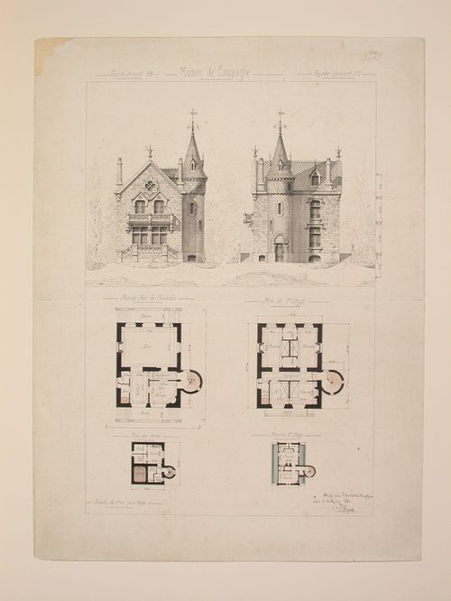
- These elevations and plans show a country house with a conically-roofed tower and Gothic Revival stonework, notably balusters and window mouldings. The two rendered elevations are situated in a forest landscape. There is a cursory section to the right of the border, apparently detailing floor heights.
DR1987:0312
Description:
- These elevations and plans show a country house with a conically-roofed tower and Gothic Revival stonework, notably balusters and window mouldings. The two rendered elevations are situated in a forest landscape. There is a cursory section to the right of the border, apparently detailing floor heights.
Personnes et institutions:
Sujet:
architecture
architecture
Date:
3 May 1860
3 May 1860
Titre:
Rendered elevations and plans for a Gothic Revival country house
Actions:
DR1987:0312
Description:
- These elevations and plans show a country house with a conically-roofed tower and Gothic Revival stonework, notably balusters and window mouldings. The two rendered elevations are situated in a forest landscape. There is a cursory section to the right of the border, apparently detailing floor heights.
Classification:
dessins
dessins
Date:
3 May 1860
3 May 1860
Personnes et institutions:
Sujet:
architecture
architecture
Classification:
photographies
photographies
Numéro de référence:
ARCH276683
Description:
File contains visual reference material and landscape architecture projects by other firms. Includes unidentified site photographs, slides of city fountains, graphic references, Battersea Power Station Revitalization project, London and Walter Forest proposal for the Tacoma Thea Foss Waterway Public Esplanade by Ben Tre Ltd.
Personnes et institutions:
Date:
ca. 2000-2001
ca. 2000-2001
Titre:
Visual reference material and landscape architecture projects by other firms
Actions:
ARCH276683
Description:
File contains visual reference material and landscape architecture projects by other firms. Includes unidentified site photographs, slides of city fountains, graphic references, Battersea Power Station Revitalization project, London and Walter Forest proposal for the Tacoma Thea Foss Waterway Public Esplanade by Ben Tre Ltd.
Classification:
photographies
photographies
Date:
ca. 2000-2001
ca. 2000-2001
Personnes et institutions:
Classification:
dessins
dessins
Actions:
Numéro de référence:
DR1987:0313
Description:
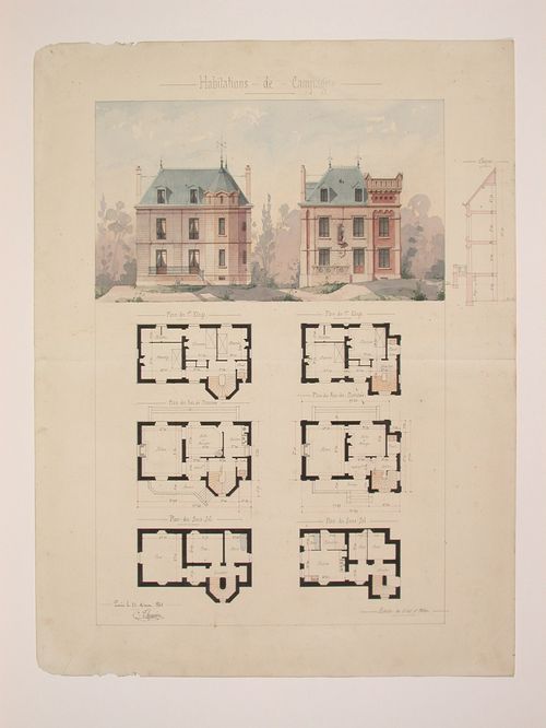
- These elevations and plans show a Gothic Revival country house with round and octagonal towers. The elevations are executed in alternating bands of brick and stone. The two rendered elevations are situated in a forest landscape. There is a cursory section to the left of the border, apparently detailing floor heights.
DR1987:0313
Description:
- These elevations and plans show a Gothic Revival country house with round and octagonal towers. The elevations are executed in alternating bands of brick and stone. The two rendered elevations are situated in a forest landscape. There is a cursory section to the left of the border, apparently detailing floor heights.
Personnes et institutions:
Sujet:
architecture
architecture
Date:
13 December 1860
13 December 1860
Titre:
Rendered elevations and plans for a Gothic Revival country house
Actions:
DR1987:0313
Description:
- These elevations and plans show a Gothic Revival country house with round and octagonal towers. The elevations are executed in alternating bands of brick and stone. The two rendered elevations are situated in a forest landscape. There is a cursory section to the left of the border, apparently detailing floor heights.
Classification:
dessins
dessins
Date:
13 December 1860
13 December 1860
Personnes et institutions:
Sujet:
architecture
architecture
Niveau de description archivistique:
Projet
Projet
Numéro de référence:
AP075.S1.1979.PR07
Description:
Project series documents Cornelia Hahn Oberlander's landscape project for Montiverdi Estates, located on the western slopes of Caulfield, West Vancouver. Oberlander worked on this project from 1979 to 1982, year of the completion. Oberlander worked on the site plan for the estate with Arthur Erickson and Eva Matsuzaki. The project consists in 20 custom houses, designed by Erickson, and nestled into a forest on a rock plateau overlooking Howe Sound. The estate, built on a slope, comprises four types of houses: uphill units, terrace units, coutyard units and downhill units. The project series contains textual records, such as correspondence, including with architect and client, Oberlander's concept development notes, research, specifications, a geotechnical report, cost estimates. The project is also documented through a design developement drawing showing planting and a plant list, and six working drawings, including landscape plans, a site plan and a site section.
Personnes et institutions:
Date:
1979-1982
1979-1982
Titre:
Montiverdi Estates, West Vancouver, British Columbia (1979)
Actions:
AP075.S1.1979.PR07
Description:
Project series documents Cornelia Hahn Oberlander's landscape project for Montiverdi Estates, located on the western slopes of Caulfield, West Vancouver. Oberlander worked on this project from 1979 to 1982, year of the completion. Oberlander worked on the site plan for the estate with Arthur Erickson and Eva Matsuzaki. The project consists in 20 custom houses, designed by Erickson, and nestled into a forest on a rock plateau overlooking Howe Sound. The estate, built on a slope, comprises four types of houses: uphill units, terrace units, coutyard units and downhill units. The project series contains textual records, such as correspondence, including with architect and client, Oberlander's concept development notes, research, specifications, a geotechnical report, cost estimates. The project is also documented through a design developement drawing showing planting and a plant list, and six working drawings, including landscape plans, a site plan and a site section.
Niveau de description archivistique:
Project
Project
Date:
1979-1982
1979-1982
Personnes et institutions:
Classification:
dessins
Quantité:
3 conceptual drawing(s)
dessins
Quantité:
3 conceptual drawing(s)
Numéro de référence:
DR1995:0240:001-003
Description:
conceptual thumbnail sketches with annotations; time, frequency, location, and movement chart allowing "five dimensional information [to be] presented on a two dimensional chart" (Price 1984, p.39); regional map of Portsmouth, Isle of Wight, New Forest, Southampton showing roads, railways, wooded areas, built areas, and beaches at low tide.
Personnes et institutions:
Titre:
Conceptual thumbnail sketches with annotations
Actions:
DR1995:0240:001-003
Description:
conceptual thumbnail sketches with annotations; time, frequency, location, and movement chart allowing "five dimensional information [to be] presented on a two dimensional chart" (Price 1984, p.39); regional map of Portsmouth, Isle of Wight, New Forest, Southampton showing roads, railways, wooded areas, built areas, and beaches at low tide.
Classification:
dessins
Quantité:
3 conceptual drawing(s)
dessins
Quantité:
3 conceptual drawing(s)
Personnes et institutions: