


Metaphors for the Nile
Samaa Elimam traces readings of the world's longest river
In the 1960s, Egyptian schoolchildren learned that the Nile Valley is a lotus flower, stems rooted in the tributaries of Sudan and Ethiopia, petals blossoming in the Egyptian delta.1 This romantic image repressed a long history of conflict over the waters of the Nile, one that persists to this day. Throughout the twentieth century, historians, engineers, and politicians employed a series of metaphors for the Nile to justify colonial and nationalist measures of river management. How did these technical, corporeal, and botanical metaphors naturalize the conquest of the river during this period, obscuring the fraught imperial relationship between Egypt and Sudan? Who has the power to liken and to equate? And how do the enduring effects of these spectral figures continue to haunt geopolitical conflicts currently erupting in the region?
The way we describe our environments both reveals our assumptions and lays the groundwork for how we shape them. Depicting a territory in word and image is akin to surveying it. In the case of the Nile Valley, map and metaphor have been critical tools of figuration for claiming power over territory. They operate on the premise that if the river could be made to resemble an object external to it, then it could be managed like that object. Geographical metaphors in particular assume a view from above, instantly reducing a vast transnational river region into a symbol through which geopolitics are simplified and abstracted.
-
According to my mother, Azza Kandil, who attended primary school in Cairo from 1960–1966. ↩
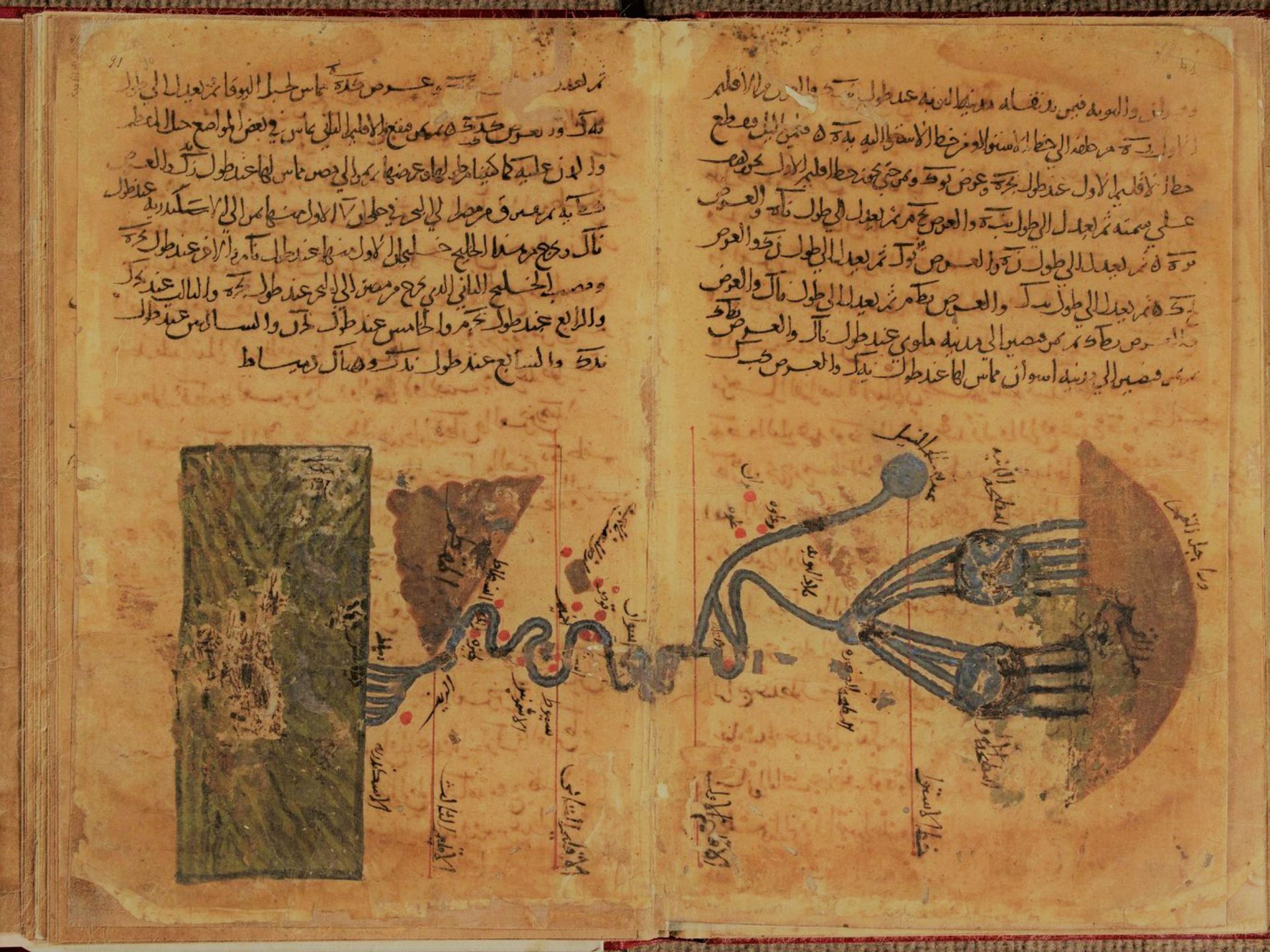
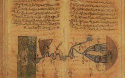
Muhammad ibn Musa al-Khwarizmi, “The Nile,” Kitab Surat al-ard [Book of the Image of the Earth], 1036, MS 4.245, fol. 30v, National and University Library of Strasbourg
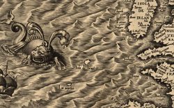
Metaphors reveal worldviews. Over the course of its storied past, the Nile Valley has inspired a plenitude of poetic comparisons. Ancient cosmograms and medieval maps pictured its snaking course, pondered its seeming endlessness, speculated on its elusive source. The Nile appears at the center of the world in Arab cartographer Muhammad al-Idrisi’s circular world map. Whereas Herodotus noted the Nile’s peculiar hydrology flowing “upside down” relative to other rivers, in the Muslim cartographic tradition, it typically drains from the top to the bottom of the page.1
Ninth-century geographer Muhammad ibn Musa al-Khwarizmi depicted the meandering Nile stretched horizontally across the spread of a manuscript folio.2 While the mouth of the river spills into a rectangular Mediterranean Sea on the left, its purported source hides in the mythic Mountains of the Moon to the right (fig. 1). The river travels across the page in the direction of Arabic script. Extending across three ancient climes, traversing six cataracts, and passing through the line of the equator, the Nile’s snaking course is studded with notable landmarks and small towns along the way. Regardless of orientation, ancient and medieval descriptions of the Nile formed the core of a cosmology of the earth.
But in the modern era, colonial powers contending for control of the Upper Nile mobilized new, particularly violent, figurations. During the nineteenth century, the Ottoman viceroy of Egypt Mehmed Ali Pasha (r. 1805–1848) and his dynasty subjected the Nile landscape to an ambitious project of modernization. With the aim of extending its territorial boundaries toward the southern frontier, the viceroyalty launched an invasion of Sudan in 1821 that would last for six decades. This was the first of a series of Egyptian forays into Sudan that would continue well into the twentieth century and complicate ties between the Nilotic countries to this day. It also marked the start of a new era of textual and verbal figurations of the river, namely, a campaign predicated on the “unity of the Nile Valley.”3
Metaphors colonize. In 1882, the British occupied an Egypt heavily in debt after the construction of the Suez Canal. In subsequent years, they developed a geopolitical vision for the Nile that underscored Egypt’s dependency on its upstream neighbors for its water supply. Using the prospect of a sovereign Sudan as leverage against Egypt, in 1896, the British waged the Anglo-Egyptian War on Sudan.
Winston Churchill’s ensuing account, The River War (fig. 2), opens with an image illustrating his conception of British hegemony over the Nile Valley: “The Soudan is joined to Egypt by the Nile, as a diver is connected with the surface by his air-pipe. Without it there is only suffocation.”4 This was not just a sadistic image by a statesman anxious over the potential loss of territory to French adversaries. Rather, it served as an operative metaphor for British colonial policy in East Africa over the next half century. Pitting Egypt and Sudan against one another, Britain’s divide-and-rule strategy legitimized its continued intervention in the Nile Valley. Curiously, Churchill’s metaphor transposes one necessity for another—water for air. And while the real threat was water shortage, death by thirst, his was an image of inundation, death by drowning.
The war culminated in the Anglo-Egyptian Condominium of 1899, a joint agreement on “the future administration of the Soudan.” Its rhetorical strategy restored nineteenth-century Ottoman-Egyptian rule by defining the colonization of Sudan as a British “reconquest” of those territories “temporarily lost to Egypt,” a result of “the two Governments acting in concert.”5 But this was not simply rhetoric—the reconquest of Sudan relied largely on the sacrifice of Egyptian troops, including Sudanese recruits, while British and Egyptian flags flew side by side across the Upper Nile.
-
Lorraine Daston, Against Nature (Cambridge, MA: MIT Press, 2019), 15. A recent article addressing the Nile GERD conflict depicts the map from south to north following the flow of the river. Max Bearak and Sudarsan Raghavan, “Africa’s Largest Dam Powers Dreams of Prosperity in Ethiopia — And Fears of Hunger in Egypt,” Washington Post, 15 October 2020. ↩
-
Muhammad ibn Musa al-Khwarizmi, Kitab Surat al-Ard [Book of the Image of Earth], c. 850. ↩
-
Eve Troutt Powell, A Different Shade of Colonialism: Egypt, Great Britain, and the Mastery of the Sudan (Berkeley: University of California Press, 2003), 7. ↩
-
Winston Churchill and Francis William Rhodes, The River War: An Historical Account of the Reconquest of the Soudan, vol. I (New York: Longmans, Green and Co., 1899), 2. ↩
-
“Appendix E: Agreement Between Her Britannic Majesty’s Government and the Government of His Highness the Khedive of Egypt, relative to the Future Administration of the Soudan,” in Churchill and Rhodes, 486–487. ↩
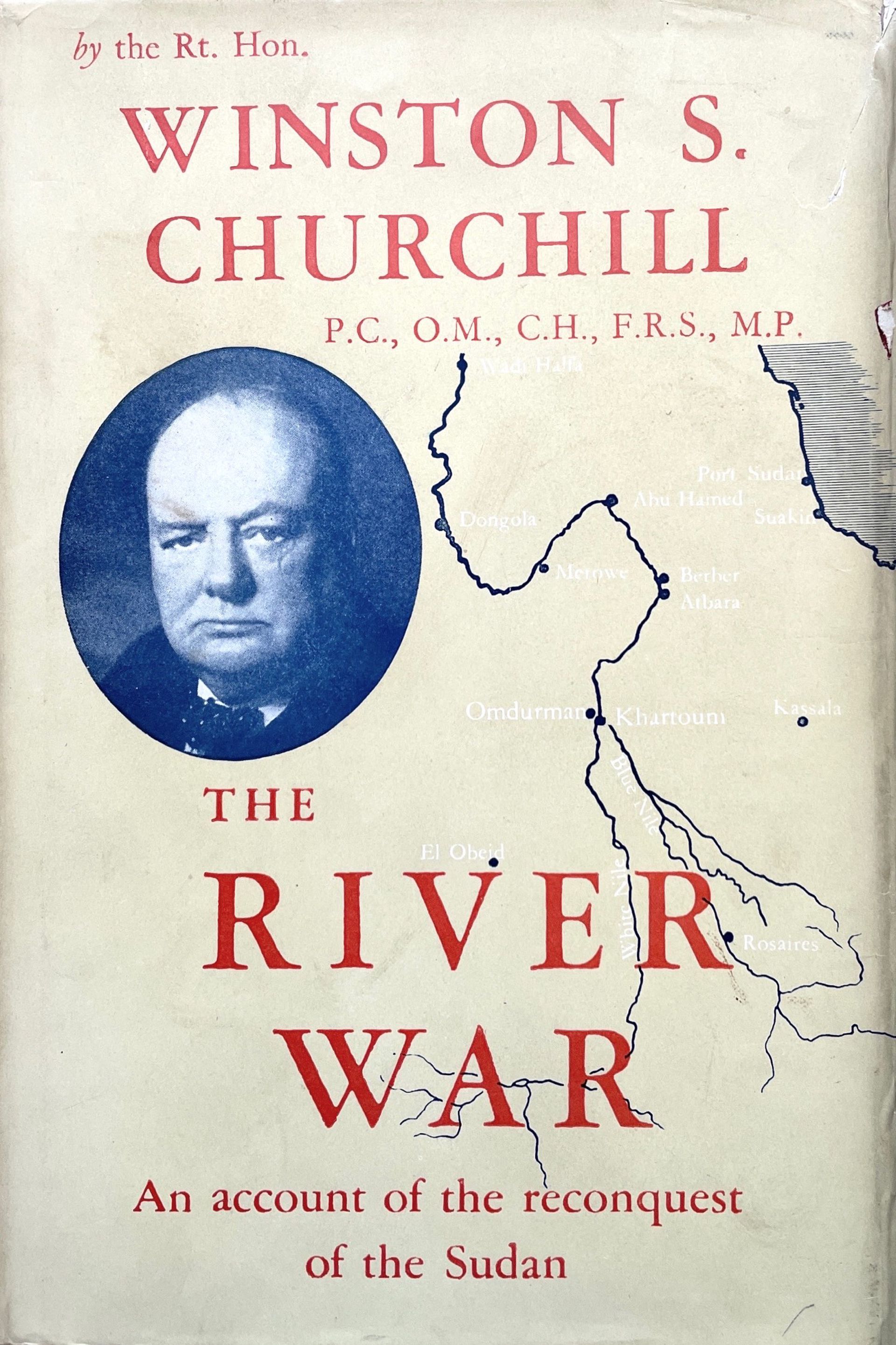
Figure 2: Cover, Winston S.Churchill, The River War: An Historical Account of the Reconquest of the Sudan, 3rd ed., (London: Eyre and Spottiswoode, 1949). Image courtesy of Churchill Book Collector
Metaphors govern. When Egypt gained nominal independence from Britain in 1922, the image of a unified Nile Valley, this time unified against the British, took over. An Anglo-Egyptian Treaty signed in 1929 recognized the “natural and historical rights of Egypt to the waters of the Nile,” and allowed Egypt to veto any upstream engineering project that would infringe on those rights. Adhering to the terms of the condominium, Britain pushed Egypt out of Sudan and retained presence in the region despite discontent on both sides. In 1951, Egypt’s King Faruq repealed the terms of the agreement and declared the two countries legally united under his rule as “The Kingdom of Egypt and Sudan.” References to the past “unity of the Nile Valley” dominated the propaganda of this move, visible in a stamp designed to commemorate the unification (fig. 3). Such images grounded sovereignty in geography.
Just one year later, when Egypt’s Free Officers launched a revolution to overthrow the king, the new government led by Muhammad Naguib and Gamal Abd al-Nasser favored Sudanese independence.1 Egyptian nationalist historians lamented the loss, arguing that “Sudan is the natural extension of Egypt.”2 Drawing on the moral authority of Nature, they compared the Nile to a date palm, unable to bear fruit without its southern roots.3 A leading Egyptian historian of Sudan, Muhammad Fu’ad Shukri, wrote a speech that Prime Minister Mahmud al-Nuqrashi would deliver before the UN Security Council in 1947, making a case for Egypt’s claim on Sudan.4 In it, he employed the same image of the palm tree to justify continued colonization.
Nationalist engineers followed. Having recently been syndicated, their new bimonthly professional journal, Majallat al-Muhandisīn, became a vehicle for the brazen display of nationalism. The 1947 issue featured a series of lectures devoted to the “Unity of the Nile Valley” (fig. 4). Amid articles on joint infrastructure projects and the economic benefits of unification, they anthropomorphized the Nile. “The Valley,” they wrote, “like the human body, would weaken and deteriorate, unless all its parts work in unison.”5 Engineers compared the river to a human being, one whose obedient southern body would perish without the direction of its northern mind.6 Severing one part of the valley from the other, that is, would result in the demise of both. Like the historians, engineers argued that “the unity of the Valley is a fact imposed by Nature upon us.” Apart from “the natural, hydraulic, and economic ties,” they reasoned, the unification of Egypt and Sudan is predicated on the “inseparable bonds” of “language, religion, and blood.”7 This corporeal imagery made visible the purported interdependence of the two countries while validating undertones of racial superiority.
-
Born and raised in Khartoum, the first president of Egypt, Muhammad Naguib, was half-Sudanese. ↩
-
Al-Sayyid Nasr, al-Wujud al-Misri fi Afriqya fi al-fatra min 1820 ila 1899 [The Egyptian Presence in Africa from 1820 to 1899] (Cairo: Dar al-Ma’arif, 1981), 13. See also ʻAbbās Muṣṭafá ʻAmmār, The Unity of the Nile Valley: Its Geographical Bases and Its Manifestations in History (Cairo: Govt. Press, 1947). ↩
-
Muḥammad Fuʼād Shukrī, Miṣr wa-al-siyādah ʻalá al-Sūdān [Egypt and its Sovereignty over Sudan] (Cairo: Dār al-Fikr al-ʻArabī, 1946); and Muḥammad Fuʼād Shukrī, al-Ḥukm al-Miṣrī fī al-Sūdān 1820-1885 [Egyptian Rule in the Sudan, 1820–1885] (Cairo: Dār al-Fikr al-ʻArabī, 1947). ↩
-
Gabriel R. Warburg, “The Turco-Egyptian Sudan: A Recent Historiographical Controversy,” Welt Des Islams 31, no. 2 (1991): 201. ↩
-
S. Gawdat Bey, “Introduction to the Series of Lectures Given by Egyptian Experts on the Unity of the Nile Valley,” Majallat al-Muhandisīn [The Engineers’ Journal], 9–10. ↩
-
Warburg, “The Turco-Egyptian Sudan,” 200–202. Nationalist party members like physician Ahmad Fu’ad took the metaphor further, calling Egypt the “thinking head,” and Sudan the “active body”; the Nile was their shared heart. Fu’ad quoted in Anwar al-Jindi, A’lam wah ashab aqlam (Cairo: Dar Nahdat Misr, c. 1966), 41. ↩
-
H.E. Osman Muharram, “Summary of the Speech Delivered by Osman Muharram Pasha on the Unity of the Nile Valley,” Majallat al-Muhandisīn, 25. ↩
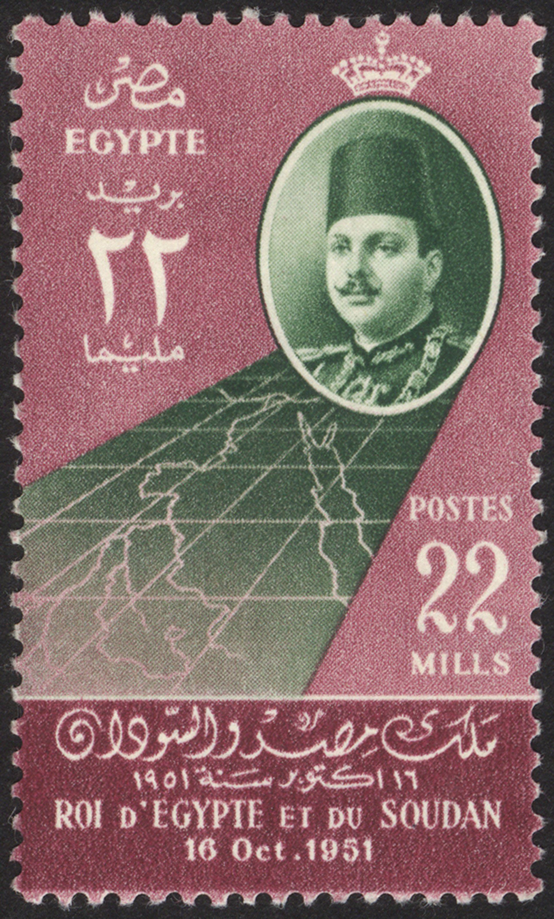
Figure 3: Stamp commemorating the abrogation of the Anglo-Egyptian Treaty. Royal Egyptian Post for King Faruq, “Roi d’Egypte et du Soudan,” 16 October 1951, Image Alamy Stock Photos
Metaphors circulate. As late as the 1980s, Egyptian historians continued to draw on such organic figurations. In a 1988 book on the Egyptian colonization of Sudan, Abd al-Azim Ramadan begins his second chapter by considering the following passage:
If the reader looks at a map of the Nile Valley, he cannot fail to be struck by its peculiar resemblance to a palm tree. At the top, the verdant delta spreads like graceful leaves and foliage. The stem is slightly twisted, for the Nile makes a vast bend as it flows through the deserts. South of Khartoum the likeness is again perfect, and the roots of the tree begin to stretch deep into Sudan. I can imagine no better illustration of the intimate link between Egypt and its southern provinces.1
Ramadan then reveals that the quote is not “from a patriotic Egyptian or Sudanese writer, rather, these are the words of a colonial statesman […] when the British ruled over Sudan in the name of Egypt.” Indeed, the metaphor belonged to none other than Churchill.2 Besides its Orientalist contours, the palm tree, rendered in Churchill’s artful words and translated in Ramadan’s lyrical Arabic, was so useful an image that it underpinned Egyptian hegemony over the Nile even after the British left. This apparently innocuous figure was a colonial invention that had traveled half a century through the pens and pages of influential Egyptian historians.3
Ensconced in the soil of Sudan, this colonial palm apparently had no roots in Ethiopia, as if it were not rain in the Ethiopian Highlands that contributed more than 85 percent of the river’s flow. The tree’s distorted image of Egyptian-Sudanese continuity minus Ethiopia reverberated in post-colonial agreements over Nile water distribution. In 1959, another Anglo-Egyptian Treaty allocated 66 percent of river’s waters to Egypt, 22 to Sudan, and the rest to evaporation, neglecting the water rights of any of the upstream countries through which the river flowed, including Ethiopia.
It was this botanical trope—transplanted into the more delicate, innocent, and ancient symbol of the lotus flower—that landed on the desks of primary school students in the 1960s. Though appearing to nurture ideas of interdependence and collaboration, the floral figure in fact cultivated an ideology of timeless Egyptian dominion over the Nile.
Tracing how we inherited metaphors like the palm, the body, or the lotus illuminates current irresolvable conflicts around the Grand Ethiopian Renaissance Dam (GERD), which began construction in 2011. Accustomed to receiving the bounty of the Nile through colonial-era treaties, Egypt stands in staunch defense of the status quo. Rejecting this deeply colonial legacy, Ethiopia sees the dam as a remedy to the decades-long disregard of its water rights. GERD rejects the palm and threatens to withhold the waters that sustain it.
-
ʻAbd al-ʻAẓīm Ramaḍān, Ukdhūbat al-istiʻmār al-Miṣrī lil-Sūdān [The Falsity of Egyptian Imperialism in Sudan: An Historical Perspective] (Cairo: al-Hayʾah al-Miṣrīyah lil-Kitāb, 1988), 107–108. ↩
-
Churchill and Rhodes, The River War, vol. II, 389–390. Churchill’s own passage elaborates on the metaphor: “The water—the life of the Delta—is drawn from the Soudan and passes up the channel of the Nile, as the sap passes up the stem of the tree, to produce a fine crop of fruit above.” ↩
-
Egyptian historians used Churchill’s palm reference out of context, without citing his incentive. Churchill used the metaphor in The River War to uphold England’s position against the French in the struggle for control of the Nile Valley, which culminated in the Fashoda Incident of 1898. ↩
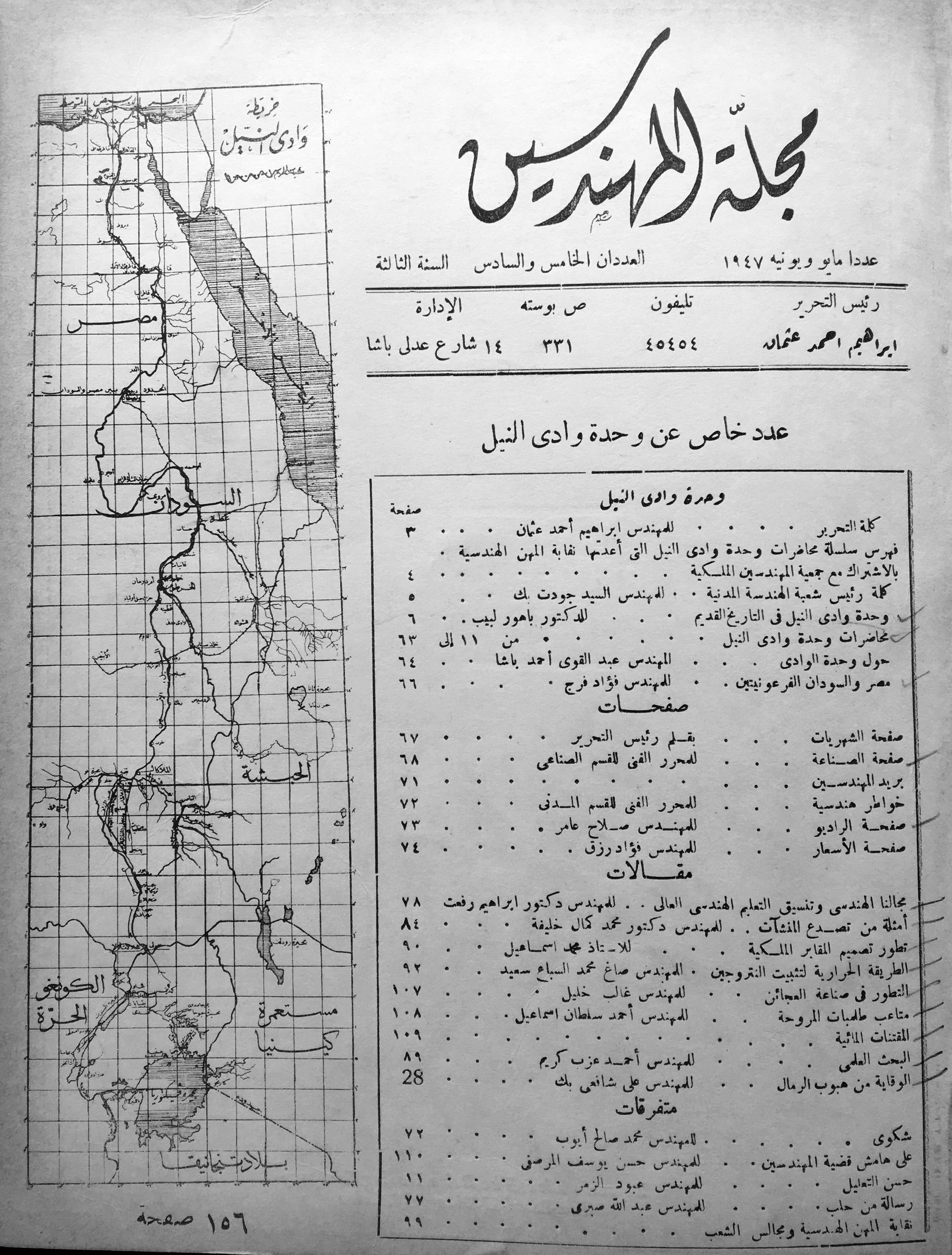
Figure 4: The Engineers [Majallat al-Muhandisin], May/June 1997. Library of the Egyptian Society of Engineers
Metaphors linger. Nowhere is this more evident than in the late-twentieth-century rhetoric of developmentalism. Any global development agency report introduces its subject by rehearsing Herodotus’s platitude that Egypt is the “gift” of the Nile.1 Amid the seemingly endless Sahara, the river is a “lifeline,” a geographical miracle in an otherwise dry, barren landscape.2 In a 1991 article, Timothy Mitchell points to World Bank reports seeped with visual tropes that describe the Nile as “but an elongated oasis in the midst of the desert.”3 Likewise, a USAID report paints the image of a “narrow ribbon of cultivated land” so thin it can barely contain its inhabitants. Mitchell shows that these figurations reduce water scarcity in the Nile Valley to a problem of nature, an accident of geography. As with our nationalist engineers, development agencies draw on a discourse of expertise and professionalism to set themselves apart from their imageable object of analysis.
Across the twentieth century, metaphors for the Nile have occluded the longstanding struggle over water rights in the region, serving to naturalize racial superiority and legitimize colonial rule. As power moved between hands, metaphors followed—from colonial breathing device to postcolonial body, nationalist palm tree to neocolonial ribbon. They brought the Nile down to a relatable scale, one that facilitated acts of destruction—cracking an apparatus, drowning a body, uprooting a tree. After all, these objects were more easily managed than one of the longest rivers in the world. Attending to such metaphors unearths our assumptions about the storied landscape and helps us break with the violent histories they carry.
-
Herodotus, The History, Book II, trans. David Grene (Chicago: University of Chicago Press, 1987), 5. ↩
-
Timothy Mitchell, “America’s Egypt: Discourse of the Development Industry,” Middle East Report, no. 169 (March/April 1991): 18–34. ↩
-
US Department of Agriculture, Egypt: Major Constraints to Increasing Agricultural Productivity, Foreign Economic Report 120 (Washington, DC, 1976), quoted in Mitchell, 24. ↩